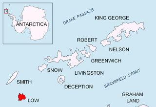
Ivan Asen Point is a narrow rocky point projecting 680 m into Osmar Strait from the southeast coast of Smith Island in the South Shetland Islands, Antarctica. It forms the southwest side of the entrance to Ivan Asen Cove and the northeast side of the entrance to Yarebitsa Cove, and separates the glacier termini of Dragoman Glacier to the north and Armira Glacier to the south.

Garmen Point is a point on the northwest coast of Smith Island, South Shetland Islands situated 13.65 km north-northeast of Cape James, 6.12 km south-southwest of Markeli Point and 19.65 km southwest of Cape Smith. Formed by an offshoot of Mount Foster. Bulgarian early mapping in 2008. Named after the settlement of Garmen in southwestern Bulgaria.

Lakatnik Point is a point on the northwest coast of Smith Island, South Shetland Islands situated 1.6 km north-northeast of Lista Point, 11 km north-northeast of Cape James, 2.66 km southwest of Garmen Point and 22 km southwest of Cape Smith. Formed by an offshoot of Neofit Peak. Bulgarian early mapping in 2008. Named after the settlement of Lakatnik in western Bulgaria.

Hisarya Cove is the 950 m wide cove on the northwest side of Osmar Strait indenting for 500 m the southeast coast of Smith Island in the South Shetland Islands, Antarctica south of Dupnitsa Point and 7.6 km northeast of Cape James. Its head is fed by Letnitsa Glacier. Bulgarian early mapping in 2009.

Elin Pelin Point is a point on the northwest coast of Smith Island, South Shetland Islands situated 4.6 km north-northeast of Cape James and 4.8 km south-southwest of Lista Point. Bulgarian early mapping in 2009. Named after the Bulgarian writer Elin Pelin.

Suhindol Point is a point on the southeast coast of Smith Island, South Shetland Islands projecting 450 m southeastwards into Osmar Strait, and situated 3.54 km east-northeast of Cape James and 4.3 km southwest of Dupnitsa Point. Bulgarian early mapping in 2009. Named after the town of Suhindol in northern Bulgaria.

Dupnitsa Point is a point forming the northeast side of the entrance to Hisarya Cove in Smith Island, South Shetland Islands. Situated 8.2 km northeast of Cape James. Bulgarian early mapping in 2009. Named after the town of Dupnitsa in southwestern Bulgaria.

Batak Point is a point on the northwest coast of Smith Island, South Shetland Islands situated 7 km north-northeast of Cape James, 2.5 km south-southwest of Lista Point and 1.7 km northwest of Organa Peak. Bulgarian early mapping in 2009. Named after the town of Batak in southern Bulgaria.

Markeli Point is a point on the northwest coast of Smith Island in the South Shetland Islands, Antarctica, projecting 1.2 km west-southwestwards into Drake Passage. Situated on the north side of the entrance to Cabut Cove 14.5 km southwest of Cape Smith, 2 km south-southwest of Gregory Point and 19.8 km north-northeast of Cape James. Bulgarian early mapping in 2009. Named after the medieval fortress of Markeli in southeastern Bulgaria.

Delyan Point is a point on the northwest coast of Smith Island, South Shetland Islands forming the northeast side of the entrance to Vedena Cove. Situated 4 km west-southwest of Cape Smith, 10.66 km northeast of Markeli Point and 1.4 km northwest of Matochina Peak. Bulgarian early mapping in 2009. Named after Peter Delyan – Czar Peter II of Bulgaria, 1040-1041 AD.

Solnik Point is a rocky point projecting 550 m from the northwest coast of Low Island in the South Shetland Islands, Antarctica. Forming the south side of the entrance to Kazichene Cove. Situated 4.1 km southwest of Cape Wallace and 11.15 km north of Cape Garry.

Kubadin Point is the ice-covered point on the southwest side of the entrance to Linevo Cove on the southeast coast of Smith Island in the South Shetland Islands, Antarctica. The point is named after the settlement of Kubadin in Southeastern Bulgaria.

Varbak Point is the ice-covered point on the southwest side of the entrance to Pakusha Cove on the southeast coast of Smith Island in the South Shetland Islands, Antarctica. The point is named after the settlement of Varbak in Northeastern Bulgaria.

Medovene Point is the ice-covered point on the northeast side of the entrance to Zapalnya Cove on the southeast coast of Smith Island in the South Shetland Islands, Antarctica. The point is named after the settlement of Medovene in Northeastern Bulgaria.

Razdel Point is the ice-covered point on the southwest side of the entrance to Zapalnya Cove and northeast side of the entrance to Nikolov Cove on the southeast coast of Smith Island in the South Shetland Islands, Antarctica. The point is named after the settlements of Razdel in Northeastern and Southeastern Bulgaria.

Velikan Point is the ice-covered point on the southwest side of the entrance to Nikolov Cove on the southeast coast of Smith Island in the South Shetland Islands, Antarctica. The point is named after the settlement of Velikan in Southern Bulgaria.

Sredets Point is the ice-covered point on the southeast coast of Smith Island in the South Shetland Islands, Antarctica, projecting 400 m into Osmar Strait and separating the glacier termini of Krivodol Glacier to the north and Pashuk Glacier to the south.

Skalina Point is the ice-covered point on the southwest side of the entrance to Yarebitsa Cove on the southeast coast of Smith Island in the South Shetland Islands, Antarctica. It is named after the settlement of Skalina in Southern Bulgaria.

Presnakov Island is the 390 m long in southeast-northwest direction and 100 m wide rocky island lying off the west coast of Low Island in the South Shetland Islands, Antarctica.

Venev Point is the rocky east entrance to Berraz Bay on the north coast of Low Island in the South Shetland Islands, Antarctica.


