
Guam is an organized, unincorporated territory of the United States in the Micronesia subregion of the western Pacific Ocean. It is the westernmost point and territory of the United States ; its capital Hagåtña (144°45'00"E) lies further west than Melbourne, Australia (144°57'47"E). In Oceania, Guam is the largest and southernmost of the Mariana Islands and the largest island in Micronesia. Guam's capital is Hagåtña, and the most populous village is Dededo.

Hagåtña is the capital village of the United States territory of Guam. From the 18th through mid-20th century, it was Guam's population center, but today it is the second smallest of the island's 19 villages in both area and population. However, it remains one of the island's major commercial districts in addition to being the seat of government.

Apra Harbor, also called Port Apra, is a deep-water port on the western side of the United States territory of Guam. It is considered one of the best natural ports in the Pacific Ocean. The harbor is bounded by Cabras Island and the Glass Breakwater to the north and the Orote Peninsula in the south. Naval Base Guam and the Port of Guam are the two major users of the harbor. It is also a popular recreation area for boaters, surfers, scuba divers, and other recreationalists.

The Seal of Guam appears in the middle of the Flag of the United States territory of Guam. It depicts Agaña Bay near Hagåtña, a local proa and a palm tree. Charles Alan Pownall approved the seal in 1946. It depicts a coconut palm on the shore with a sailboat nearby on the water. The name "Guam" appears in red across the center of the seal.

Yona is a village in the United States territory of Guam.

The Talofofo Falls are a scenic series of cascades on the Ugum River on the island of Guam. They are located in the southeast of the island, inland from Talofofo Bay.

Talofofo Bay is an inlet in the south-eastern coast of the island of Guam at the mouth of the Talofofo River in the village of Talo'fo'fo.

Cocos Lagoon appears as a small incomplete coral atoll attached to the south-western coast of Guam near the area of the village of Merizo. It stretches about 5.5 km (3.4 mi) east-west and 3.5 km (2.2 mi) north-south, covering an area of more than 10 km2 (3.9 sq mi).

The following is an alphabetical list of articles related to the United States Territory of Guam.
The Ramu languages are a family of some thirty languages of Northern Papua New Guinea. They were identified as a family by John Z'graggen in 1971 and linked with the Sepik languages by Donald Laycock two years later. Malcolm Ross (2005) classifies them as one branch of a Ramu – Lower Sepik language family. Z'graggen had included the Yuat languages, but that now seems doubtful.

Talo'fo'fo, formerly Talofofo, is a village located in the southern part of the United States territory of Guam, on the east coast. The village center is located in the hills above the coast, while the smaller coastal community below the cliff is known as Ipan.
The Tamolan languages are a small family of clearly related languages spoken in the region of the Guam River in Madang Province, Papua New Guinea.

The Agat World War II Amtrac is an underwater relic of World War II, located off Ga'an Point in Agat Bay on the west side of the island of Guam. It is the remains of an LVT 4, an amphibious tracked landing vehicle. It is located about 500 yards (460 m) off Agat Invasion Beach in 45 feet (14 m) of water, and was described as being in good condition when it was discovered and surveyed in 1985. These vehicles were used during the 1944 Battle of Guam, in which American forces recaptured the island from occupying Japanese forces. This particular vehicle does not appear to exhibit significant war damage. This is the most intact of the three Amtracks remaining on Guam from the 850 that participated in the battle. It was re-surveyed by maritime archaeological field schools conducted from 2009 to 2012.
The Guam River is a river in northern Papua New Guinea.

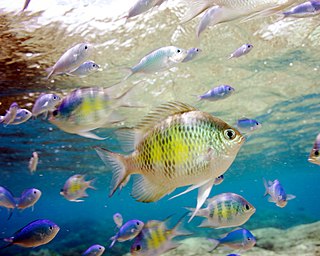
Underwater diving encompasses a variety of economically and culturally significant forms of diving on the U.S. island territory of Guam. Scuba diving tourism is a significant component of the island's tourist activity, in particular for visitors from Japan and South Korea. Recreational diving by Guam residents has a lesser but still substantial economic impact. Marine biologists have raised concerns about the effect of diving upon the health of some of Guam's reefs. Recreational dive sites on Guam include submerged shipwrecks, such as the double wrecks of SMS Cormoran and Tokai Maru, and natural features, such as Blue Hole.

Kizugawa Maru, or Kitsugawa Maru, is a World War II-era Japanese water tanker sunk in Apra Harbor, Guam. Damaged by a submarine torpedo attack off Guam on April 8, 1944, she was towed into port for repairs. In port, she was further damaged in three separate U.S. air attacks during the Mariana and Palau Islands campaign. Deemed irreparable, Kizugawa Maru was scuttled by shore guns on June 27, 1944. The shipwreck is now a deep recreational diving site.
Piti Bomb Holes Marine Preserve is a marine protected area comprising all of Piti Bay on the western coast of Guam, located off of the village of Piti in the Philippine Sea. The defining "bomb hole" features, named because they look like bomb craters in the reef flat, are actually natural percolation pits where fresh water filters into the shallow lagoon at a depth of 25 to 30 feet. The largest pit houses the commercial Fish Eye Marine Park tourist attraction, which includes a wooden pier to a underwater observatory and a Seawalker tour of the lagoon bottom. It is visited by more than 200,000 people annually. The Piti preserve is the most ecologically diverse of Guam's five marine preserves. The pit around Fish Eye is a popular snorkeling and recreational diving site.
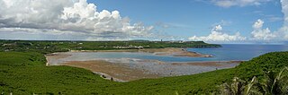
Pago Bay is the largest bay on the U.S. territory of Guam, located at the mouth of Pago River on the island's eastern coast. There is extensive evidence of CHamoru settlement before Spanish colonization during the late seventeenth century. During the Spanish-Chamorro Wars, the Spanish transferred the populations of Tinian and Aguigan to the village of Pago. However, a smallpox epidemic in 1856 killed much of the village's population and the Spanish moved survivors to other villages, leaving the bay shoreline largely uninhabited. The bay is popular with fishermen and recreationalists, and was the site of new housing development in the 2000s.
Guam v. United States, 593 U.S. ___ (2021), was a U.S. Supreme Court case dealing with a dispute on fiscal responsibility for environmental and hazardous cleanup of the Ordot Dump created by the United States Navy on the island of Guam in the 1940s, which Guam then ran after becoming a territory in 1950 until the landfill's closure in 2011. The Supreme Court ruled unanimously that under the Comprehensive Environmental Response, Compensation, and Liability Act of 1980, Guam had filed its lawsuit to recover a portion of cleanup costs for the landfill from the United States government in a timely manner, allowing their case to proceed.

