In-situ conservation is the on-site conservation or the conservation of genetic resources in natural populations of plant or animal species, such as forest genetic resources in natural populations of tree species. This process protects the inhabitants and ensures the sustainability of the environment and ecosystem.

The Satpura Range is a range of hills in central India. The range rises in eastern Gujarat running east through the border of Maharashtra and Madhya Pradesh and ends in Chhattisgarh. The range parallels the Vindhya Range to the north, and these two east–west ranges divide Indian Subcontinent into the Indo-Gangetic plain of northern India and the Deccan Plateau of the south. The Narmada River originates from north-eastern end of Satpura in Amarkantak, and runs in the depression between the Satpura and Vindhya ranges, draining the northern slope of the Satpura range, running west towards the Arabian Sea. The Tapti River originates in the eastern-central part of Satpura, crossing the range in the center and running west at the range's southern slopes before meeting the Arabian Sea at Surat, draining the central and southern slopes of the range. Multai, the place of Tapti river origin is located about 465 kilometer far, south-westerly to Amarkantak, separated across by the hill range. The Godavari River and its tributaries drain the Deccan plateau, which lies south of the range, and the Mahanadi River drains the easternmost portion of the range. The Godavari and Mahanadi rivers flow into the Bay of Bengal. At its eastern end, the Satpura range meets the hills of the Chotanagpur Plateau. The Satpura Range is a horst mountain and is flanked by Narmada Graben in the north and much smaller but parallel Tapi Graben in the south.

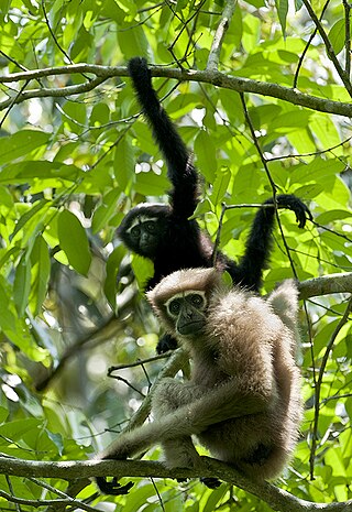
Gee's golden langur, also known as simply the golden langur, is an Old World monkey found in a small region of Western Assam, India and the neighboring foothills of the Black Mountains of Bhutan. Long considered sacred by many Himalayan people, the golden langur was first brought to the attention of the Western world by the naturalist Edward Pritchard Gee in the 1950s. Adult males have a cream to golden coat with darker flanks while the females and juveniles are lighter. The golden langur has a black face and a long tail up to 100 cm (39 in) in length. It lives in high trees and has a herbivorous diet of fruits, leaves, seeds, buds, and flowers. The average group size is eight individuals, with a ratio of several females to each adult male. It is one of the most endangered primate species of India and Bhutan.

Dibru-Saikhowa National Park is a national park located in Dibrugarh and Tinsukia districts, Assam, India. It was designated a Biosphere Reserve in July 1997 with an area of 765 km2 (295 sq mi), including a core area of 340 km2 (130 sq mi) and a buffer zone of 425 km2 (164 sq mi).

The Brahmaputra Valley semi-evergreen forests is a tropical moist broadleaf forest ecoregion of Northeastern India, southern Bhutan and adjacent Bangladesh.
Barpeta Road or Athiyabari as known earlier is a town and Commercial City of Assam a municipal board in Barpeta district in the state of Assam, India.

Manas National Park is a national park, Project Tiger reserve, and an elephant reserve in Assam, India. Located in the Himalayan foothills, it borders the Royal Manas National Park in Bhutan. The park is known for its rare and endangered endemic wildlife such as the Assam roofed turtle, hispid hare, golden langur and pygmy hog. It also hosts the only known population of pygmy hogs in the world. Manas is also famous for its population of the wild water buffalo. Because of its exceptional biodiversity, scenery, and variety of habitats, Manas National Park is a biosphere reserve and a UNESCO World Heritage Site.

The Eastern Himalayan broadleaf forests is a temperate broadleaf forest ecoregion found in the middle elevations of the eastern Himalayas, including parts of Nepal, India, Bhutan, Myanmar and China. These forests have an outstanding richness of wildlife.

The biodiversity of Assam, a state in North-East India, makes it a biological hotspot with many rare and endemic plant and animal species. The greatest success in recent years has been the conservation of the Indian rhinoceros at the Kaziranga National Park, but a rapid increase in human population in Assam threatens many plants and animals and their habitats.

This article discusses the geological origin, geomorphic characteristics, and climate of the northeastern Indian state of Assam. Extending from 89° 42′ E to 96° E longitude and 24° 8′ N to 28° 2′ N latitude, it has an area of 78,438 km2, similar to that of Ireland or Austria.

India is one of the most biodiverse regions and is home to a large variety of wildlife. It is one of the 17 megadiverse countries and includes three of the world's 36 biodiversity hotspots – the Western Ghats, the Eastern Himalayas, and the Indo-Burma hotspot.

The Manas River, known in Bhutan as the Drangme Chhu, is a transboundary river in the Himalayan foothills between southern Bhutan, India, and China. It is the largest of Bhutan's four major river systems, with the other three being the Amo Chu or Torsa River, the Wang Chu or Raidak, and the Puna Tshang Chu or Sankosh. It is met by three other major streams before it again debouches into India in western Assam. The river flows for a total length of 400 kilometres (250 mi), including through Tibet for 24 km (15 mi), Bhutan for 272 kilometres (169 mi), and Assam for 104 kilometres (65 mi) before it joins the mighty Brahmaputra River at Jogighopa. A major tributary of the Manas, the Aie River, joins it in Assam at Bangpari.
The Hollongapar Gibbon Sanctuary, formerly known as the Gibbon Wildlife Sanctuary or Hollongapar Reserved Forest, is an isolated protected area of evergreen forest located in Assam, India. The sanctuary was officially constituted and renamed in 1997. Set aside initially in 1881, its forests used to extend to the foothills of the Patkai mountain range.
Pakke Tiger Reserve, is a Project Tiger reserve in the East Kameng district of Arunachal Pradesh in Northeast India. The 862 km2 (333 sq mi) reserve is protected by the Department of Environment and Forest of Arunachal Pradesh. It was known as Pakhui Tiger Reserve, but renamed in April 2001 by the Governor of Arunachal Pradesh. It has won India Biodiversity Award 2016 in the category of 'Conservation of threatened species' for its Hornbill Nest Adoption Programme.
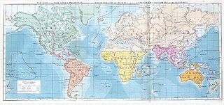
Biogeographic classification of India is the division of India according to biogeographic characteristics. Biogeography is the study of the distribution of species (biology), organisms, and ecosystems in geographic space and through geological time. India has a rich heritage of natural diversity. India ranks fourth in Asia and tenth in the world amongst the top 17 mega-diverse countries in the world. India harbours nearly 11% of the world's floral diversity comprising over 17500 documented flowering plants, 6200 endemic species, 7500 medicinal plants and 246 globally threatened species in only 2.4% of world's land area. India is also home to four biodiversity hotspots—Andaman & Nicobar Islands, Eastern Himalaya, Indo-Burma region, and the Western Ghats. Hence the importance of biogeographical study of India's natural heritage.

Arunachal Pradesh is primarily a hilly tract nestled in the foothills of the Himalayas in northeast India. It is spread over an area of 83,743 km2 (32,333 sq mi). 98% of the geographical area is land out of which 80% is forest cover; 2% is water. River systems in the region, including those from the higher Himalayas and Patkoi and Arakan Ranges, eventually drain into the Brahmaputra River.

Sangu-Matamuhari or Sangu Wildlife Sanctuary is a wildlife sanctuary—IUCN category II —situated in Bandarban District, Chittagong Division, Bangladesh. It is part of the Sangu reserve forest. It is under the Lama Forest Division of the Bangladesh Forest Department. Its bio-ecological zone is in Chittagong Hills and Chittagong Hill Tracts.
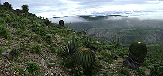
The Tehuacán-Cuicatlán biosphere reserve is a protected natural area located in southeastern Mexico. Its name derives from its two main locations: Cuicatlán and Tehuacán, in the latter are their administrative offices, covers 490,186 hectares distributed among 21 municipalities in the state of Puebla and Oaxaca.
Omo Forest Reserve is a preserved area of tropical rainforest in Ogun state, in the south-western part of Nigeria. It is located about 135 km (84 mi) northeast of Lagos and 80 km (50 mi) east of Ijebu Ode. This nature reserve covers an area of 130,500 hectares. The average rainfall is around 2,000 mm (80 in). The terrain is largely flat and well-drained, with some low rolling hills, and forms part of the Omo River watershed.

Raimona National Park is located in extreme western part of Assam, India. It is spread across Gossaigaon and Kokrajhar subdivisions of Kokrajhar district of Bodoland Territorial Region.

