
Guam is a U.S. territory in the western Pacific Ocean, at the boundary of the Philippine Sea. It is the southernmost and largest member of the Mariana Islands archipelago, which is itself the northernmost group of islands in Micronesia. The closest political entity is the Commonwealth of the Northern Mariana Islands (CNMI), another U.S. territory. Guam shares maritime boundaries with CNMI to the north and the Federated States of Micronesia to the south. It is located approximately one quarter of the way from the Philippines to Hawaii. Its location and size make it strategically important. It is the only island with both a protected harbor and land for multiple airports between Asia and Hawaii, on an east-west axis, and between Papua New Guinea and Japan, on a north-south axis.

Umatac, formerly called Umata, is a village on the southwestern coast of the United States territory of Guam. The month of March in the Chamorro language is "Umatalaf," or "to catch guatafi," which is believed to be the root word of Umatac. The village's population has decreased since the island's 2000 census.
The area code 671 is the local telephone area code of the United States territory of Guam. It was created with the beginning of permissive dialing on July 1, 1997, replacing Guam's previous International Telecommunication Union country code 671, at the end of permissive dialing on July 1, 1998.

Dulce Nombre de Maria Cathedral Basilica is a Roman Catholic cathedral in Guam. It is the seat of the Archbishop of the Roman Catholic Archdiocese of Agaña. It is located on the site where the island's first Catholic church was constructed in 1669, under the guidance of Padre San Vitores. The present building looms above the palm trees and is a familiar landmark in downtown Hagåtña. The basilica enshrines the image of Santa Marian Kamalen, Patroness of Guam.
Guam Highway 2 is one of the primary automobile routes in the United States territory of Guam.
Guam Highway 4 (GH-4) is one of the primary automobile highways in the United States territory of Guam.
Southern High School is a public secondary school located at 1 Jose Perez Leon Guerrero Drive in the village of Santa Rita, in the United States territory of Guam. The school, a part of the Guam Public School System, opened in 1997 and serves grades 9 through 12. Southern High serves the villages of Santa Rita, Agat, Asan, Inarajan, Merizo, Piti, Talofofo, Umatac, and Yona.
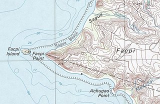
Facpi Point is a headland in the south-west of the island of Guam. It is three kilometers due west of Mount Lamlam, and five kilometers north of Umatac village. The point was designated a National Natural Landmark in 1972. Facpi Point marks the southern end of Agat Bay, as well as an end point of the boundary between the villages of Agat and Umatac. A small islet, Facpi Island, is off the tip of the point.

Mount Bolanos is a south-west peak in the United States territory of Guam.
Fuerte Nuestra Señora de la Soledad or Fort Soledad is a fort in Umatac, Guam built by the Spanish in 1810 and named for Our Lady of Solitude. It is the last of the four forts build around Umatac Bay.

The Umatac Outdoor Library, located on Guam Highway 4 in Umatac, Guam, was built in 1933 by Francisco Quinata Sanchez and Umatac villagers. It was listed on the National Register of Historic Places in 1999.

Cetti Bay is an oceanic bay and historic site near Umatac, Guam, that is listed on the National Register of Historic Places.
Fort San Jose is a former Spanish fortification on the island of Guam, now a United States territory. It is located north of the village of Umatac, on a hill over looking both Fouha Bay and Umatac Bay, the place were Spanish galleons traveling between Manila in the Spanish Philippines and Acapulco, Mexico stopped for water and supplies.
Fort Santo Angel was a Spanish fortress on the island of Guam, now a United States territory. Located on a promontory on the west coast of the island in the northernmost part the Umatac Bay in Umatac, the fort's remains are among the oldest known Spanish-era structures on the island; a fort is documented to have been standing here since 1742, and to still be in use in the early 19th century. The fort provided protection for the anchorage used by Spanish galleons on the trade route between Manila and Acapulco, Mexico. Perched on a monolith, there remains a plaza 40 by 24 feet of flagstone surrounded by a manposteria wall 1 foot (30 cm) high and 18 inches (46 cm) thick. The remains of a guardroom and a second, smaller platform, lie to its west.
The Fouha Bay Site is a prehistoric archaeological site near the village of Umatac on the southwestern coast of Guam. First identified in 1977 during a systematic survey by archaeologist Fred Reinman, the site was radiocarbon dated to CE 1200–1400. However, differences in the rate of deposition along stream and river banks make these dates uncertain. Because of a proportionally larger number of archaeological sites in the geologically different parts of eastern Guam, this site is significant in understanding how deposition rates affect site dating methods.
The Francisco Q. Sanchez Elementary School is a historic school building on the north sode of Guam Highway 2 in Umatac, Guam. It is a single-story International style structure, with two classroom wings flanking a central administration area. The building was designed by noted Internationalist architect Richard J. Neutra, and built in 1953 adjacent to the San Dionisio Church Ruins. Neutra's design sought to integrate the school with its surrounding environment, and provides a panoramic view of Umatac Bay. The building is one of four buildings built pursuant to a master plan developed by Neutra and Robert J. Alexander. It is Umatac's only school.

The geology of Guam formed as a result of mafic, felsic and intermediate composition volcanic rocks erupting below the ocean, building up the base of the island in the Eocene, between 33.9 and 56 million years ago. The island emerged above the water in the Eocene, although the volcanic crater collapsed. A second volcanic crater formed on the south of the island in the Oligocene and Miocene. In the shallow water, numerous limestone formations took shape, with thick alternating layers of volcanic material. The second crater collapsed and Guam went through a period in which it was almost entirely submerged, resembling a swampy atoll, until structural deformation slowly uplifted different parts of the island to their present topography. The process of uplift led to widespread erosion and clay formation, as well as the deposition of different types of limestone, reflecting different water depths.
Mount Llicho is a mountain on island of the United States territory of Guam. Llicho's closest populated area is Umatac.
