Related Research Articles

Aridisols are a soil order in USDA soil taxonomy. Aridisols form in an arid or semi-arid climate. Aridisols dominate the deserts and xeric shrublands, which occupy about one third of the Earth's land surface. Aridisols have a very low concentration of organic matter, reflecting the paucity of vegetative production on these dry soils. Water deficiency is the major defining characteristic of Aridisols. Also required is sufficient age to exhibit subsoil weathering and development. Limited leaching in aridisols often results in one or more subsurface soil horizons in which suspended or dissolved minerals have been deposited: silicate clays, sodium, calcium carbonate, gypsum or soluble salts. These subsoil horizons can also be cemented by carbonates, gypsum or silica. Accumulation of salts on the surface can result in salinization.
USDA soil taxonomy (ST) developed by the United States Department of Agriculture and the National Cooperative Soil Survey provides an elaborate classification of soil types according to several parameters and in several levels: Order, Suborder, Great Group, Subgroup, Family, and Series. The classification was originally developed by Guy Donald Smith, former director of the U.S. Department of Agriculture's soil survey investigations.

Mollisol is a soil type which has deep, high organic matter, nutrient-enriched surface soil, typically between 60 and 80 cm in depth. This fertile surface horizon, called a mollic epipedon, is the defining diagnostic feature of Mollisols. Mollic epipedons are created by long-term addition of organic materials derived from plant roots and typically have soft, granular soil structure.
In soil science, podzols are the typical soils of coniferous or boreal forests and also the typical soils of eucalypt forests and heathlands in southern Australia. In Western Europe, podzols develop on heathland, which is often a construct of human interference through grazing and burning. In some British moorlands with podzolic soils, cambisols are preserved under Bronze Age barrows.

Gelisols are an order in USDA soil taxonomy. They are soils of very cold climates which are defined as containing permafrost within two meters of the soil surface. The word "Gelisol" comes from the Latin gelare meaning "to freeze", a reference to the process of cryoturbation that occurs from the alternating thawing and freezing characteristic of Gelisols.
A vertisol is a Soil Order in the USDA soil taxonomy and a Reference Soil Group in the World Reference Base for Soil Resources (WRB). It is also defined in many other soil classification systems. In the Australian Soil Classification it is called vertosol. Vertisols have a high content of expansive clay minerals, many of them belonging to the montmorillonites that form deep cracks in drier seasons or years. In a phenomenon known as argillipedoturbation, alternate shrinking and swelling causes self-ploughing, where the soil material consistently mixes itself, causing some vertisols to have an extremely deep A horizon and no B horizon.. This heaving of the underlying material to the surface often creates a microrelief known as gilgai.
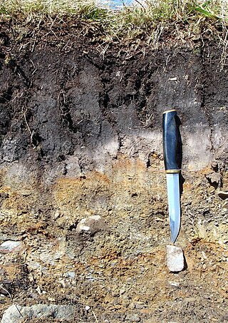
A soil horizon is a layer parallel to the soil surface whose physical, chemical and biological characteristics differ from the layers above and beneath. Horizons are defined in many cases by obvious physical features, mainly colour and texture. These may be described both in absolute terms and in terms relative to the surrounding material, i.e. 'coarser' or 'sandier' than the horizons above and below.

Entisols are soils, as defined under USDA soil taxonomy, that do not show any profile development other than an A-horizon. Entisols have no diagnostic horizons, and are unaltered from their parent material, which could be unconsolidated sediment, or rock. Entisols are the most common soils, occupying about 16% of the global ice-free land area.

The World Reference Base for Soil Resources (WRB) is an international soil classification system for naming soils and creating legends for soil maps. The currently valid version is the fourth edition 2022. It is edited by a working group of the International Union of Soil Sciences (IUSS).

In soil classification, an Umbrisol is a soil with a dark topsoil and in which organic matter has accumulated within the mineral surface soil—in most cases with low base saturation—to the extent that it significantly affects the behaviour and utilization of the soil. Umbrisols are the counterpart of comparable soils with a high base saturation.

Brown earth is a type of soil. Brown earths are mostly located between 35° and 55° north of the Equator. The largest expanses cover western and central Europe, large areas of western and trans-Uralian Russia, the east coast of America and eastern Asia. Here, areas of brown earth soil types are found particularly in Japan, Korea, China, eastern Australia and New Zealand. Brown earths cover 45% of the land in England and Wales. They are common in lowland areas on permeable parent material. The most common vegetation types are deciduous woodland and grassland. Due to the reasonable natural fertility of brown earths, large tracts of deciduous woodland have been cut down and the land is now used for farming. They are normally located in regions with a humid temperate climate. Rainfall totals are moderate, usually below 76 cm per year, and temperatures range from 4 °C in the winter to 18 °C in the summer. They are well-drained fertile soils with a pH of between 5.0 and 6.5.

A gleysol or gley soil is a hydric soil that unless drained is saturated with groundwater for long enough to develop a characteristic gleyic colour pattern. The pattern is essentially made up of reddish, brownish, or yellowish colours at surfaces of soil particles and/or in the upper soil horizons mixed with greyish/blueish colours inside the peds and/or deeper in the soil. Gleysols are also known as Gleyzems, meadow soils, Aqu-suborders of Entisols, Inceptisols and Mollisols, or as groundwater soils and hydro-morphic soils.
The Canadian System of Soil Classification is more closely related to the American system than any other, but they differ in several ways. The Canadian system is designed to cover only Canadian soils. The Canadian system dispenses with the sub-order hierarchical level. Solonetzic and Gleysolic soils are differentiated at the order level.

Albeluvisol was a Reference Soil Group of the first edition (1998) and the second edition (2006) of the World Reference Base for Soil Resources (WRB). In the third edition of the WRB (2014), Albeluvisols were replaced by the broader defined Retisols. An Albeluvisol is a soil with a thin, dark surface horizon on a bleached subsurface horizon that tongues into a clay illuviation (Bt) horizon. The Bt horizon has an irregular or broken upper boundary resulting from the tonguing of bleached soil material into the illuviation horizon. Albeluvisols correlate with Glossaqualfs, Glossocryalfs and Glossudalfs in the USDA soil taxonomy.
Kastanozem is one of the 32 Reference Soil Groups of the World Reference Base for Soil Resources (WRB). These soils are brighter than Chernozems, and are related to the Mollisols in the USDA soil taxonomy. They are rich in humus, and originally covered with early maturing native grasslands vegetation, which produces a characteristic brown surface layer in the first meter in depth. They have a relative high level of available calcium ions bound to soil particles and can have a petrocalcic horizon between 25 and 100 cm thick.
Luvisols are a group of soils, comprising one of the 32 Reference Soil Groups in the international system of soil classification, the World Reference Base for Soil Resources (WRB). They are widespread, especially in temperate climates, and are generally fertile. Luvisols are widely used for agriculture.
The Olympic soil series is a type of deep, dark reddish brown moderately fine-textured soil which has developed on mafic rock such as basalt. The series covers large areas in southwestern Washington and western Oregon, and usually supports forests of Douglas-fir, red alder, western redcedar, western hemlock, and bigleaf maple.
The Polish Soil Classification is a soil classification system used to describe, classify and organize the knowledge about soils in Poland.

Anthroposols are soils which have been profoundly modified or constructed by humans. They typically have one or more of their natural soil horizons modified, removed or replaced. The word anthroposol is derived from the Greek words anthropos, meaning man and genes meaning caused. Anthroposols are typically found on industrial, commercial, urban and resources extraction sites as well as throughout transportation, fuel and power corridors.
A Retisol is a Reference Soil Group of the World Reference Base for Soil Resources (WRB). Retisols are characterized by clay migration and an additional specific feature: The clay-poorer and lighter coloured eluvial horizon intercalates netlike into the clay-richer more intensely coloured illuvial horizon. The illuvial horizon is the diagnostic argic horizon, and the intercalation is called retic properties.
References
- 1 2 3 IUSS Working Group WRB (2015). "World Reference Base for Soil Resources 2014, Update 2015" (PDF). World Soil Resources Reports 106, FAO, Rome. Archived (PDF) from the original on 2018-08-29. Retrieved 2019-01-09.
| | This soil science–related article is a stub. You can help Wikipedia by expanding it. |