
A canyon, or gorge, is a deep cleft between escarpments or cliffs resulting from weathering and the erosive activity of a river over geologic time scales. Rivers have a natural tendency to cut through underlying surfaces, eventually wearing away rock layers as sediments are removed downstream. A river bed will gradually reach a baseline elevation, which is the same elevation as the body of water into which the river drains. The processes of weathering and erosion will form canyons when the river's headwaters and estuary are at significantly different elevations, particularly through regions where softer rock layers are intermingled with harder layers more resistant to weathering.

Ouray County is a county located in the U.S. state of Colorado. As of the 2020 census, the population was 4,874. The county seat is Ouray. Because of its rugged mountain topography, Ouray County is also known as the Switzerland of America.

Montrose County is a county located in the U.S. state of Colorado. As of the 2020 census, the population was 42,679. The county seat is Montrose, for which the county is named.

Ouray is a home rule municipality that is the county seat of Ouray County, Colorado, United States. The city population was 1,000 as of the 2010 census. The Ouray Post Office has the ZIP Code 81427. Ouray's climate, natural alpine environment, and scenery have earned it the nickname "Switzerland of America".

The Town of Ridgway is the home rule municipality that is the most populous municipality in Ouray County, Colorado, United States. The town is a former railroad stop on the Uncompahgre River in the northern San Juan Mountains. The town population was 713 at the 2000 census and 924 according to the 2010 census.
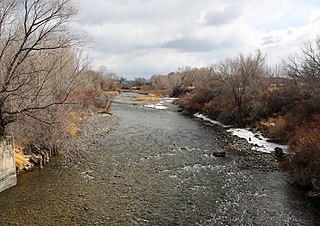
The Uncompahgre River is a tributary of the Gunnison River, approximately 75 mi (121 km) long, in southwestern Colorado in the United States. Lake Como at 12,215 ft (3723m) in northern San Juan County, in the Uncompahgre National Forest in the northwestern San Juan Mountains is the headwaters of the river. It flows northwest past Ouray, Ridgway, Montrose, and Olathe and joins the Gunnison at Confluence Park in Delta.
U.S. Route 550 (US 550) is a spur of U.S. Highway 50 that runs from Bernalillo, New Mexico to Montrose, Colorado in the western United States. The section from Silverton to Ouray is frequently called the Million Dollar Highway. It is one of the roads on the Trails of the Ancients Byway, one of the designated New Mexico Scenic Byways.

Uncompahgre National Forest is a U.S. National Forest covering 955,229 acres in parts of Montrose, Mesa, San Miguel, Ouray, Gunnison, Hinsdale, San Juan, and Delta Counties in western Colorado. Its headquarters are in Delta County, in the city of Delta. It borders the San Juan National Forest to the south.

The Uncompahgre Plateau in western Colorado is a distinctive large uplift part of the Colorado Plateau. Uncompahgre is a Ute word that describes the water: "Dirty Water" or "Rocks that make Water Red".

Unaweep Canyon is a geologically unique canyon that cuts across the Uncompahgre Plateau, Mesa County, in western Colorado. It is unique because two creeks, East Creek and West Creek, flow out of opposite ends of the canyon, separated by the almost imperceptible Unaweep Divide. State Highway 141 runs inside Unaweep Canyon between Whitewater and Gateway, one segment of the Colorado-designated Unaweep/Tabeguache Scenic Byway. The Unaweep Divide, elevation 7,048 ft (2,148 m), is near mile marker 135 on SH 141.

Red Mountain Pass elevation 11,018 ft (3,358 m) is a mountain pass in the San Juan Mountains of western Colorado in the United States.

Yankee Boy Basin is an alpine basin in Ouray County, southwestern Colorado. It is in the San Juan Mountains, protected within Uncompahgre National Forest.
The San Juan Skyway Scenic and Historic Byway is a 236-mile (380 km) All-American Road, National Forest Scenic Byway, and Colorado Scenic and Historic Byway located in Dolores, La Plata, Montezuma, San Juan, and San Miguel counties, Colorado, USA. The byway forms a loop in southwestern Colorado traversing the heart of the San Juan Mountains. The San Juan Skyway reaches its zenith at Red Mountain Pass at elevation 11,018 feet (3,358 m). Mesa Verde National Park was one of the origonal UNESCO World Heritage Sites. The Silverton Historic District and the Telluride Historic District are National Historic Landmarks.

Ridgway Dam is an earthen dam on the Uncompahgre River which impounds Ridgway Reservoir, located about 6 miles (10 km) north of the town of Ridgway in Ouray County, Colorado. The dam is 332 ft (101 m) high and 2,465 ft (751 m) long, with a capacity of 84,410 acre⋅ft (104,120,000 m3) of water.
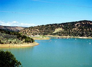
Ridgway Reservoir is a lake impounded by Ridgway Dam on the Uncompahgre River north of the town of Ridgway in Ouray County, Colorado in the western United States.
U.S. Route 50 (US 50) is a part of the U.S. Highway System that travels from West Sacramento, California, to Ocean City, Maryland. In the U.S. state of Colorado, US 50 is a major highway crossing through the lower midsection of the state. It connects the Western Slope with the lower Front Range and the Arkansas Valley. The highway serves the areas of Pueblo and Grand Junction as well as many other smaller areas along its corridor. The long-term project to upgrade the highway from two lanes to a four lane expressway between Grand Junction and Montrose was completed in January 2005. Only about 25% of the remainder of highway 50 in Colorado is four lane expressway.

Eldredge is an unincorporated community in Ouray County, Colorado, United States. The community is located between Colona and Ridgway - both within Ouray County - north of Ridgway State Park on the Colorado stretch of U.S. Route 550 and the Uncompahgre River.

The Ouray Hydroelectric Power Plant is a conventional hydroelectric power station located in Ouray, Colorado.

Abrams Mountain, also known as Mount Abram or Mount Abrams, is a 12,801-foot-elevation mountain summit located on the shared boundary of Ouray County with San Juan County in southwest Colorado, United States. It is situated four miles south of the town of Ouray, on land managed by Uncompahgre National Forest. It is part of the San Juan Mountains, which are a subset of the Rocky Mountains, and is west of the Continental Divide. Topographic relief is significant as the north aspect rises 3,800 feet (1,160 meters) above Uncompahgre Gorge in 1.5 mile. Historic mines are located on the slopes of Abrams Mountain. This iconic feature of the Ouray landscape can be seen for many miles while driving Highway 550 south from Montrose toward Ouray, and it dominates the San Juan Skyway from Red Mountain Pass to Ironton Park.

