Related Research Articles

Hydrology is the scientific study of the movement, distribution, and management of water on Earth and other planets, including the water cycle, water resources, and drainage basin sustainability. A practitioner of hydrology is called a hydrologist. Hydrologists are scientists studying earth or environmental science, civil or environmental engineering, and physical geography. Using various analytical methods and scientific techniques, they collect and analyze data to help solve water related problems such as environmental preservation, natural disasters, and water management.

A flood is an overflow of water that submerges land that is usually dry. In the sense of "flowing water", the word may also be applied to the inflow of the tide. Floods are an area of study of the discipline hydrology and are of significant concern in agriculture, civil engineering and public health. Human changes to the environment often increase the intensity and frequency of flooding, for example land use changes such as deforestation and removal of wetlands, changes in waterway course or flood controls such as with levees, and larger environmental issues such as climate change and sea level rise. In particular climate change's increased rainfall and extreme weather events increases the severity of other causes for flooding, resulting in more intense floods and increased flood risk.

A drainage basin is an area of land where all flowing surface water converges to a single point, such as a river mouth, or flows into another body of water, such as a lake or ocean. A basin is separated from adjacent basins by a perimeter, the drainage divide, made up of a succession of elevated features, such as ridges and hills. A basin may consist of smaller basins that merge at river confluences, forming a hierarchical pattern.
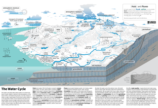
The water cycle, also known as the hydrologic cycle or the hydrological cycle, is a biogeochemical cycle that describes the continuous movement of water on, above and below the surface of the Earth. The mass of water on Earth remains fairly constant over time but the partitioning of the water into the major reservoirs of ice, fresh water, saline water and atmospheric water is variable depending on a wide range of climatic variables. The water moves from one reservoir to another, such as from river to ocean, or from the ocean to the atmosphere, by the physical processes of evaporation, transpiration, condensation, precipitation, infiltration, surface runoff, and subsurface flow. In doing so, the water goes through different forms: liquid, solid (ice) and vapor. The ocean plays a key role in the water cycle as it is the source of 86% of global evaporation.

Environmental degradation is the deterioration of the environment through depletion of resources such as quality of air, water and soil; the destruction of ecosystems; habitat destruction; the extinction of wildlife; and pollution. It is defined as any change or disturbance to the environment perceived to be deleterious or undesirable.

A hydrograph is a graph showing the rate of flow (discharge) versus time past a specific point in a river, channel, or conduit carrying flow. The rate of flow is typically expressed in cubic meters or cubic feet per second . Hydrographs often relate change of precipitation to change of discharge over time. It can also refer to a graph showing the volume of water reaching a particular outfall, or location in a sewerage network. Graphs are commonly used in the design of sewerage, more specifically, the design of surface water sewerage systems and combined sewers.
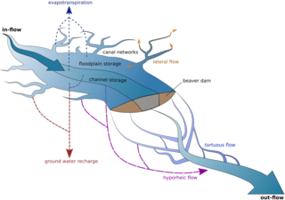
In hydrology, discharge is the volumetric flow rate of a stream. It equals the product of average flow velocity and the cross-sectional area. It includes any suspended solids, dissolved chemicals, or biologic material in addition to the water itself. Terms may vary between disciplines. For example, a fluvial hydrologist studying natural river systems may define discharge as streamflow, whereas an engineer operating a reservoir system may equate it with outflow, contrasted with inflow.

An arroyo, from Spanish arroyo, also called a wash, is a dry watercourse that temporarily or seasonally fills and flows after sufficient rain. Flash floods are common in arroyos following thunderstorms.
Ecohydrology is an interdisciplinary scientific field studying the interactions between water and ecological systems. It is considered a sub discipline of hydrology, with an ecological focus. These interactions may take place within water bodies, such as rivers and lakes, or on land, in forests, deserts, and other terrestrial ecosystems. Areas of research in ecohydrology include transpiration and plant water use, adaption of organisms to their water environment, influence of vegetation and benthic plants on stream flow and function, and feedbacks between ecological processes, the soil carbon sponge and the hydrological cycle.
The United States Environmental Protection Agency (EPA) Storm Water Management Model (SWMM) is a dynamic rainfall–runoff–subsurface runoff simulation model used for single-event to long-term (continuous) simulation of the surface/subsurface hydrology quantity and quality from primarily urban/suburban areas. It can simulate the Rainfall- runoff, runoff, evaporation, infiltration and groundwater connection for roots, streets, grassed areas, rain gardens and ditches and pipes, for example. The hydrology component of SWMM operates on a collection of subcatchment areas divided into impervious and pervious areas with and without depression storage to predict runoff and pollutant loads from precipitation, evaporation and infiltration losses from each of the subcatchment. Besides, low impact development (LID) and best management practice areas on the subcatchment can be modeled to reduce the impervious and pervious runoff. The routing or hydraulics section of SWMM transports this water and possible associated water quality constituents through a system of closed pipes, open channels, storage/treatment devices, ponds, storages, pumps, orifices, weirs, outlets, outfalls and other regulators.

Surface runoff is the unconfined flow of water over the ground surface, in contrast to channel runoff. It occurs when excess rainwater, stormwater, meltwater, or other sources, can no longer sufficiently rapidly infiltrate in the soil. This can occur when the soil is saturated by water to its full capacity, and the rain arrives more quickly than the soil can absorb it. Surface runoff often occurs because impervious areas do not allow water to soak into the ground. Furthermore, runoff can occur either through natural or human-made processes.
Runoff is the flow of water across the earth, and is a major component in the hydrological cycle. Runoff that flows over land before reaching a watercourse is referred to as surface runoff or overland flow. Once in a watercourse, runoff is referred to as streamflow, channel runoff, or river runoff. Urban runoff is surface runoff created by urbanization.

The law of water balance states that the inflows to any water system or area is equal to its outflows plus change in storage during a time interval. In hydrology, a water balance equation can be used to describe the flow of water in and out of a system. A system can be one of several hydrological or water domains, such as a column of soil, a drainage basin, an irrigation area or a city.
Streamflow, or channel runoff, is the flow of water in streams and other channels, and is a major element of the water cycle. It is one runoff component, the movement of water from the land to waterbodies, the other component being surface runoff. Water flowing in channels comes from surface runoff from adjacent hillslopes, from groundwater flow out of the ground, and from water discharged from pipes. The discharge of water flowing in a channel is measured using stream gauges or can be estimated by the Manning equation. The record of flow over time is called a hydrograph. Flooding occurs when the volume of water exceeds the capacity of the channel.

An hydrological transport model is a mathematical model used to simulate the flow of rivers, streams, groundwater movement or drainage front displacement, and calculate water quality parameters. These models generally came into use in the 1960s and 1970s when demand for numerical forecasting of water quality and drainage was driven by environmental legislation, and at a similar time widespread access to significant computer power became available. Much of the original model development took place in the United States and United Kingdom, but today these models are refined and used worldwide.

Intermittent, temporary or seasonal rivers or streams cease to flow every year or at least twice every five years. Such rivers drain large arid and semi-arid areas, covering approximately a third of the earth's surface. The extent of temporary rivers is increasing, as many formerly perennial rivers are becoming temporary because of increasing water demand, particularly for irrigation. Despite inconsistent water flow, intermittent rivers are considered land-forming agents in arid regions, as they are agents of significant deposition and erosion during flood events. The combination of dry crusted soils and the highly erosive energy of the rain cause sediment resuspension and transport to the coastal areas. They are among the aquatic habitats most altered by human activities. During the summer even under no flow conditions the point sources are still active such as the wastewater effluents, resulting in nutrients and organic pollutants accumulating in the sediment. Sediment operates as a pollution inventory and pollutants are moved to the next basin with the first flush. Their vulnerability is intensified by the conflict between water use demand and aquatic ecosystem conservation. Advanced modelling tools have been developed to better describe intermittent flow dynamic changes such as the tempQsim model.

Surface water is water located on top of land, forming terrestrial waterbodies, and may also be referred to as blue water, opposed to the seawater and waterbodies like the ocean.

A stream is a continuous body of surface water flowing within the bed and banks of a channel. Depending on its location or certain characteristics, a stream may be referred to by a variety of local or regional names. Long, large streams are usually called rivers, while smaller, less voluminous and more intermittent streams are known as streamlets, brooks or creeks.

California's interconnected water system serves over 30 million people and irrigates over 5,680,000 acres (2,300,000 ha) of farmland. As the world's largest, most productive, and potentially most controversial water system, it manages over 40 million acre-feet (49 km3) of water per year.
A water year is a term commonly used in hydrology to describe a time period of 12 months for which precipitation totals are measured. Its beginning differs from the calendar year because part of the precipitation that falls in late autumn and winter accumulates as snow and does not drain until the following spring or summer's snowmelt. The goal is to ensure that as much as possible of the surface runoff during the water year is attributable to the precipitation during the same water year.