Related Research Articles

The European Space Operations Centre (ESOC) serves as the main mission control centre for the European Space Agency (ESA) and is located in Darmstadt, Germany. ESOC's primary function is the operation of unmanned spacecraft on behalf of ESA and the launch and early orbit phases (LEOP) of ESA and third-party missions. The Centre is also responsible for a range of operations-related activities within ESA and in cooperation with ESA's industry and international partners, including ground systems engineering, software development, flight dynamics and navigation, development of mission control tools and techniques and space debris studies.

A communications satellite is an artificial satellite that relays and amplifies radio telecommunication signals via a transponder; it creates a communication channel between a source transmitter and a receiver at different locations on Earth. Communications satellites are used for television, telephone, radio, internet, and military applications. As of 1 January 2021, there are 2,224 communications satellites in Earth orbit. Most communications satellites are in geostationary orbit 22,300 miles (35,900 km) above the equator, so that the satellite appears stationary at the same point in the sky; therefore the satellite dish antennas of ground stations can be aimed permanently at that spot and do not have to move to track the satellite.

The NASA Deep Space Network (DSN) is a worldwide network of American spacecraft communication ground segment facilities, located in the United States (California), Spain (Madrid), and Australia (Canberra), that supports NASA's interplanetary spacecraft missions. It also performs radio and radar astronomy observations for the exploration of the Solar System and the universe, and supports selected Earth-orbiting missions. DSN is part of the NASA Jet Propulsion Laboratory (JPL).

A ground station, Earth station, or Earth terminal is a terrestrial radio station designed for extraplanetary telecommunication with spacecraft, or reception of radio waves from astronomical radio sources. Ground stations may be located either on the surface of the Earth, or in its atmosphere. Earth stations communicate with spacecraft by transmitting and receiving radio waves in the super high frequency (SHF) or extremely high frequency (EHF) bands. When a ground station successfully transmits radio waves to a spacecraft, it establishes a telecommunications link. A principal telecommunications device of the ground station is the parabolic antenna.
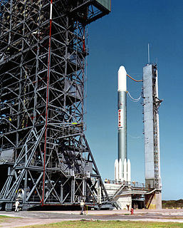
Westar 1 was America's first domestic and commercially launched geostationary communications satellite, launched by Western Union (WU) and NASA on April 13, 1974. It was built by Hughes for Western Union, using the HS-333 platform of spin-stabilized satellites. Westar 1 was the first of five Westar satellites launched by Western Union from 1974 to 1982. Westars 1, 2, and 3 were 12-transponder satellites while Westar 4 and Westar 5 were launched with 24 transponders. Western Union built a teleport in Cedar Hill, Texas, to uplink content to the Westar satellites, and another teleport that, in addition to uplink services, would become the main TT&C center for the satellite, in Glenwood, New Jersey. A sixth satellite, Westar 6, was launched in 1984 but failed to reach orbit and was retrieved by the STS-51-A Space Shuttle mission later that year. It was later refurbished and relaunched in orbit of Asia as AsiaSat 1 in 1990.
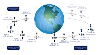
A tracking and data relay satellite (TDRS) is a type of communications satellite that forms part of the Tracking and Data Relay Satellite System (TDRSS) used by NASA and other United States government agencies for communications to and from independent "User Platforms" such as satellites, balloons, aircraft, the International Space Station, and remote bases like the Amundsen-Scott South Pole Station. This system was designed to replace an existing worldwide network of ground stations that had supported all of NASA's crewed flight missions and uncrewed satellites in low-Earth orbits. The primary system design goal was to increase the amount of time that these spacecraft were in communication with the ground and improve the amount of data that could be transferred. These TDRSS satellites are all designed and built to be launched to and function in geosynchronous orbit, 35,786 km (22,236 mi) above the surface of the Earth.

Commercial use of space is the provision of goods or services of commercial value by using equipment sent into Earth orbit or outer space. This phenomenon – aka Space Economy – is accelerating cross-sector innovation processes combining the most advanced space and digital technologies to develop a broad portfolio of space-based services. The use of space technologies and of the data they collect, combined with the most advanced enabling digital technologies is generating a multitude of business opportunities that include the development of new products and services all the way to the creation of new business models, and the reconfiguration of value networks and relationships between companies. If well leveraged such technology and business opportunities can contribute to the creation of tangible and intangible value, through new forms and sources of revenue, operating efficiency and the start of new projects leading to multidimensional positive impact. Examples of the commercial use of space include satellite navigation, satellite television and commercial satellite imagery. Operators of such services typically contract the manufacturing of satellites and their launch to private or public companies, which form an integral part of the space economy. Some commercial ventures have long-term plans to exploit natural resources originating outside Earth, for example asteroid mining. Space tourism, currently an exceptional activity, could also be an area of future growth, as new businesses strive to reduce the costs and risks of human spaceflight.
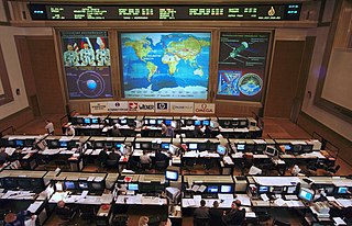
Flight controllers are personnel who aid space flight by working in such Mission Control Centers as NASA's Mission Control Center or ESA's European Space Operations Centre. Flight controllers work at computer consoles and use telemetry to monitor various technical aspects of a space mission in real time. Each controller is an expert in a specific area and constantly communicates with additional experts in the "back room". The flight director, who leads the flight controllers, monitors the activities of a team of flight controllers, and has overall responsibility for success and safety.

Maspalomas Station is an INTA-operated, ESTRACK radio antenna ground station for communication with spacecraft located at the southern area of Gran Canaria island, on the INTA campus. It is situated on the Montaña Blanca hill and is visible from the coastal resort of Meloneras, close to Maspalomas. It was originally established in the 1960s to support NASA's nascent human spaceflight program.

The Chinese Lunar Exploration Program, also known as the Chang'e Project after the Chinese moon goddess Chang'e, is an ongoing series of robotic Moon missions by the China National Space Administration (CNSA). The program incorporates lunar orbiters, landers, rovers and sample return spacecraft, launched using Long March rockets. Launches and flights are monitored by a telemetry, tracking, and command (TT&C) system, which uses 50-meter (160-foot) radio antennas in Beijing and 40-meter (130-foot) antennas in Kunming, Shanghai, and Ürümqi to form a 3,000-kilometer (1,900-mile) VLBI antenna. A proprietary ground application system is responsible for downlink data reception.

The Indian Space Research Organisation (ISRO), over the years, has established a comprehensive global network of ground stations to provide Telemetry, Tracking and Command (TTC) support to satellite and launch vehicle missions. These facilities are grouped under ISRO Telemetry, Tracking and Command Network (ISTRAC) with its headquarters at Bangalore, India.
The Canadian Advanced Nanospace eXperiment (CanX) program is a Canadian CubeSat nanosatellite program operated by the University of Toronto Institute for Aerospace Studies, Space Flight Laboratory (UTIAS/SFL). The program's objectives are to involve graduate students in the process of spaceflight development, and to provide low-cost access to space for scientific research and the testing of nanoscale devices. The CanX projects include CanX-1, CanX-2, the BRIght Target Explorer (BRITE), and CanX-4&5.
The Manned Space Flight Network was a set of tracking stations built to support the American Mercury, Gemini, Apollo, and Skylab space programs.

Indian Deep Space Network (IDSN) is a network of large antennas and communication facilities operated by the Indian Space Research Organisation to support the interplanetary spacecraft missions of India. Its hub is located at Byalalu, Ramanagar in the state of Karnataka in India. It was inaugurated on 17 October 2008 by the former ISRO chairman G. Madhavan Nair.
The Unified S-band (USB) system is a tracking and communication system developed for the Apollo program by NASA and the Jet Propulsion Laboratory (JPL). It operated in the S band portion of the microwave spectrum, unifying voice communications, television, telemetry, command, tracking and ranging into a single system to save size and weight and simplify operations. The USB ground network was managed by the Goddard Space Flight Center (GSFC). Commercial contractors included Collins Radio, Blaw-Knox, Motorola and Energy Systems.
This article incorporates public domain material from websites or documents of the National Aeronautics and Space Administration.

Global-scale Observations of the Limb and Disk (GOLD) is a heliophysics Mission of Opportunity (MOU) for NASA's Explorers program. Led by Richard Eastes at the Laboratory for Atmospheric and Space Physics, which is located at the University of Colorado Boulder, GOLD's mission is to image the boundary between Earth and space in order to answer questions about the effects of solar and atmospheric variability of Earth's space weather. GOLD was one of 11 proposals selected, of the 42 submitted, for further study in September 2011. On 12 April 2013, NASA announced that GOLD, along with the Ionospheric Connection Explorer (ICON), had been selected for flight in 2017. GOLD, along with its commercial host satellite SES-14, launched on 25 January 2018.

SpaceIL is an Israeli organization, established in 2011, that was competing in the Google Lunar X Prize (GLXP) contest to land a spacecraft on the Moon.

A ground segment consists of all the ground-based elements of a spacecraft system used by operators and support personnel, as opposed to the space segment and user segment. The ground segment enables management of a spacecraft, and distribution of payload data and telemetry among interested parties on the ground. The primary elements of a ground segment are:
Kosmos 159, E-6LS No.111, was one of many satellites designed during the Soviet space program given the designation Kosmos. This satellite was specifically designed to be a high orbit satellite used to gain information on trajectory anomalies caused by the Moon's gravitational pull. This data would have been vital to the Soviet space program and could have been key in successful manned missions to the Moon. This mission was also used to test radio communications in space.
References
- ↑ "Near Earth Network (NEN) Users' Guide" (PDF). NASA. 2010. Archived from the original (PDF) on 2011-08-15. Chapter 6, Universal Space Network Stations.
- ↑ "Universal Space Network to Provide Commercial Telemetry and Tracking for Sirius Satellite Radio". SpaceRef. 2009.
- ↑ "Universal Space Network Commercial Antenna Network Evaluation (CANE) Overview" (PDF). 2002.
- ↑ Mazarico, E; Goossens, SJ; Lemoine, FG; Neumann, GA; Torrence, MH; Rowlands, DD; et al. (2013). Improved Orbit Determination of Lunar Orbiters with Lunar Gravity Fields Obtained by the GRAIL Mission (PDF). 44th Lunar and Planetary Science Conference (2013). 1719. p. 2414.