Thuringia, officially the Free State of Thuringia, is a state of central Germany, covering 16,171 square kilometres (6,244 sq mi), the sixth smallest of the sixteen German states. It has a population of about 2.1 million.

Eisenach is a town in Thuringia, Germany with 42,000 inhabitants, located 50 kilometres west of Erfurt, 70 km southeast of Kassel and 150 km northeast of Frankfurt. It is the main urban centre of western Thuringia and bordering northeastern Hessian regions, situated near the former Inner German border. A major attraction is Wartburg castle, which has been a UNESCO World Heritage Site since 1999.

Suhl is a city in Thuringia, Germany, located SW of Erfurt, 110 kilometres NE of Würzburg and 130 kilometres N of Nuremberg. With its 37,000 inhabitants, it is the smallest of the six urban districts within Thuringia. Together with its northern neighbour-town Zella-Mehlis, Suhl forms the largest urban area in the Thuringian Forest with a population of 46,000. The region around Suhl is marked by up to 1,000-meter-high mountains, including Thuringia's highest peak, the Großer Beerberg, approximately 5 kilometres NE of the city centre.
Schmalkalden-Meiningen is a Landkreis in the southwest of Thuringia, Germany. Its neighboring districts are the districts Wartburgkreis, Gotha, Ilm-Kreis, the district-free city Suhl, the district Hildburghausen, the Bavarian district Rhön-Grabfeld, and the district Fulda in Hesse.
Wartburgkreis is a Kreis (district) in the west of Thuringia, Germany. Neighboring districts are the districts Unstrut-Hainich-Kreis, Gotha, Schmalkalden-Meiningen, and the districts Fulda, Hersfeld-Rotenburg and Werra-Meißner-Kreis in Hesse. The district has 30 municipalities, including Eisenach.

The Rhön Mountains are a group of low mountains in central Germany, located around the border area where the states of Hesse, Bavaria and Thuringia come together. These mountains, which are at the extreme southeast end of the East Hesse Highlands, are partly a result of ancient volcanic activity. They are separated from the Vogelsberg Mountains by the river Fulda and its valley. The highest mountain in the Rhön is the Wasserkuppe, which is in Hesse. The Rhön Mountains are a popular tourist destination and walking area.

Saxe-Weimar-Eisenach was a German state, created as a duchy in 1809 by the merger of the Ernestine duchies of Saxe-Weimar and Saxe-Eisenach, which had been in personal union since 1741. It was raised to a grand duchy in 1815 by resolution of the Congress of Vienna. In 1903, it officially changed its name to the Grand Duchy of Saxony, but this name was rarely used. The grand duchy came to an end in the German Revolution of 1918–19 with the other monarchies of the German Empire. It was succeeded by the Free State of Saxe-Weimar-Eisenach, which was merged into the new Free State of Thuringia two years later.

Ostheim vor der Rhön is a town in Northern Bavaria in the district of Rhön-Grabfeld in Franconia. Though politically part of Bavaria since 1947, it was historically a part of Thuringia, and remains religiously, architecturally, and to some extent culturally distinct from its immediate surroundings.

Kaltennordheim is a town in the Schmalkalden-Meiningen district, in Thuringia, Germany. It is situated in the Rhön Mountains, 22 km southwest of Bad Salzungen, and 35 km east of Fulda. The former municipalities Aschenhausen, Kaltensundheim, Kaltenwestheim, Melpers, Oberkatz und Unterweid were merged into Kaltennordheim in January 2019. At the same time, Kaltennordheim passed from the Wartburgkreis to Schmalkalden-Meiningen.

Stadtlengsfeld is a town and a former municipality in the Wartburgkreis district of Thuringia, Germany. Since 1 January 2019, it is part of the municipality Dermbach. It is situated in the Rhön Mountains, 8 km southwest of Bad Salzungen.

Philippsthal (Werra) is a market community in Hersfeld-Rotenburg district in eastern Hesse, Germany, right at the boundary with Thuringia.
Andenhausen is a village and a former municipality in the Schmalkalden-Meiningen district of Thuringia, Germany. Since 31 December 2013, it is part of the town Kaltennordheim.
Fischbach/Rhön is a village and a former municipality in the Schmalkalden-Meiningen district of Thuringia, Germany. Since 31 December 2013, it is part of the town Kaltennordheim.

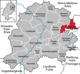
Wildeck is a municipality in Hersfeld-Rotenburg district in northeastern Hesse, Germany lying right at the boundary with Thuringia, 54 km southeast of Kassel.

Hohenroda is a municipality in Hersfeld-Rotenburg district in eastern Hesse, Germany lying right on the boundary with Thuringia.

Ehrenberg is a municipality in the district of Fulda, in Hesse, Germany.

Oberweid is a municipality in the district Schmalkalden-Meiningen, in Thuringia, Germany. It is part of the Hohe Rhön administrative community, which has its administrative centre in the municipality of Kaltennordheim.

Felda is a river of Thuringia, Germany. It flows into the Werra in Dorndorf. The main source of the Felda is located immediately south of Erbenhausen am Bergsattel between the Stellberg in the south and the Alten Mark in the north at an altitude of about 510 m; The Herpf rises in the eastern neighborhood. A left source stream, called Rodgraben, rises at about 676 m altitude on the eastern slope of the Ellenbogen and passes the place Reichenhausen immediately above the confluence.

The Rhön Cycleway is a cycle path in Germany that runs for 180 kilometres from Bad Salzungen to Hammelburg. Its route takes it through 3 states: from Thuringia via Hesse to Bavaria.
Schmalkalden-Meiningen I is an electoral constituency represented in the Landtag of Thuringia. It elects one member via first-past-the-post voting. Under the current constituency numbering system, it is designated as constituency 12. It covers the southern part of Schmalkalden-Meiningen.


