Minot is a city in and the county seat of Ward County, North Dakota, United States, in the state's north-central region. It is most widely known for the Air Force base approximately 15 miles (24 km) north of the city. With a population of 48,377 at the 2020 census, Minot is the state's fourth-most populous city and a trading center for a large part of northern North Dakota, southwestern Manitoba, and southeastern Saskatchewan. Founded in 1886 during the construction of James J. Hill's Great Northern Railway, Minot is also known as "Magic City", commemorating its remarkable growth in size over a short time.

Sunset Park is a neighborhood in the southwestern part of the borough of Brooklyn in New York City, bounded by Park Slope and Green-Wood Cemetery to the north, Borough Park to the east, Bay Ridge to the south, and Upper New York Bay to the west. The neighborhood is named after a 24.5-acre (9.9 ha) public park of the same name, located between 41st and 44th Streets and Fifth and Seventh Avenues. The region north of 36th Street is also known as Greenwood Heights or South Slope.

Downtown Brooklyn is the third largest central business district in New York City, and is located in the northwestern section of the borough of Brooklyn. The neighborhood is known for its office and residential buildings, such as the Williamsburgh Savings Bank Tower and the MetroTech Center office complex.

The Seventh Avenue station is a station on the IND Sixth Avenue Line and the IND Queens Boulevard Line of the New York City Subway. Located at the intersection of Seventh Avenue and 53rd Street in Manhattan, it is served by the D and E trains at all times, and the B train weekdays.

The Automobile Alley neighborhood and Automobile Alley Historic District in Oklahoma City is an upscale Urban area, located roughly along North Broadway Avenue in Downtown Oklahoma City. The district contains numerous low and mid-rise heritage buildings once home to the city's automobile dealerships, that today hosts many of the city's top bars and restaurants, retail shops, and urban residences alongside modern construction consisting mostly of residential housing and hotels. Automobile Alley is listed in the National Historic Register of neighborhoods.

The 50th Street station is a bi-level station on the IND Eighth Avenue and Queens Boulevard Lines of the New York City Subway, located at 50th Street and Eighth Avenue in the Hell's Kitchen neighborhood of Manhattan. The lower level, on the Queens Boulevard Line, is served by the E train at all times, and the upper level, on the Eighth Avenue Line, is served by the C at all times except late nights and the A during late nights.

The 72nd Street station is a local station on the IND Eighth Avenue Line of the New York City Subway. It is located at 72nd Street and Central Park West on the Upper West Side. It is served by the B on weekdays, the C train at all times except nights, and the A train during late nights only.

The West Fourth Street–Washington Square station is an express station and transfer stop on the IND Sixth Avenue and IND Eighth Avenue Lines of the New York City Subway, located at the intersection of West Fourth Street and Sixth Avenue in Greenwich Village, Manhattan. It is served by the A, D, E, and F trains at all times; the B and M trains on weekdays; the C train at all times except late nights; and the <F> train during rush hours in the peak direction.
When the city of Houston was founded in 1836 and incorporated in 1837, its founders—John Kirby Allen and Augustus Chapman Allen—divided it into political geographic districts called "wards". The ward system, a precursor to today's City Council districts, was a common political tool of the early 19th century, and is still used in some American cities. When the system was at its peak, the city had six wards, from the first to the sixth.
The geography of Minot, North Dakota is treated extensively in this article.

The Crescent Warehouse Historic District is a 10.5-acre (4.2 ha) historic district in Downtown Davenport, Iowa, United States. The district is a collection of multi-story brick structures that formerly housed warehouses and factories. Most of the buildings have been converted into loft apartments. The district was listed on the National Register of Historic Places in 2003.
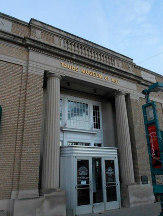
The Taube Museum of Art is an art museum in Downtown Minot, North Dakota. The museum, previously known as the Minot Art Gallery, was named after Lillian and Coleman Taube.

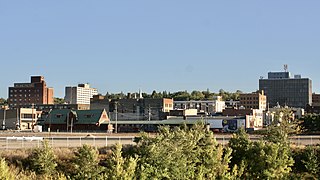
Downtown Minot is the central business district of Minot, North Dakota, located south of the Souris River in the Souris Valley. Downtown is the site of the first permanent settlement in Minot in 1886. Downtown is home to many of Minot's cultural sites of interest. It is also home to numerous galleries, stores and restaurants. The Minot Riverwalk traverses the downtown.
West Minot is a neighborhood in Minot, North Dakota, located in the Souris River Valley. It borders Oak Park to the South, North Hill to the North, Bel Air to the west and Nubbin Park to the east. The neighborhood is largely residential and there are no commercial thoroughfares, which run through the neighborhood. It received its name when at the time it was the westernmost neighborhood in Minot. Today, there are neighborhoods, such as Bel Air further west of here, but the area has retained the name West Minot. West Minot is home to the Quentin N. Burdick Jobs Center, Minot's Hebrew Cemetery and the West Minot Church of God.

Bel Air is a neighborhood in Minot, North Dakota, located in the Souris River Valley. It is roughly bound by North Hill to the north, Sixteenth Street NW to the east, Fourth Avenue NW to the south and the city limits on the west. The neighborhood was home to about a thousand people in 2010. The neighborhood is home to Bel Air Elementary School on Twenty Fifth Street NW. The neighborhood was developed as the Bel Air Addition in 1956. Fourth Avenue is home to a number of businesses in Bel Air, many of which were severely damaged in the Souris River flood in 2011. Bel Air is home to the Church of the Living God, the Bible Fellowship Church and the Christ Lutheran Church.

North Hill is a neighborhood in Minot, North Dakota, located north of the Souris River, above the Souris River Valley. It is a primarily residential neighborhood, though there are industries and businesses in the area, primarily along North Broadway and 21st Ave NW. North Hill is also home to Minot International Airport.

South Hill is a neighborhood in Minot, North Dakota, located south of the Souris River, above the Souris River Valley. It is a primarily residential neighborhood, although there are commercial zones along South Broadway, Twentieth Avenue South and around the Dakota Square Mall.
