
Wharfedale is one of the Yorkshire Dales. It is situated within the boroughs of Craven, and Harrogate in North Yorkshire, and the cities of Leeds, and Bradford in West Yorkshire. It is the upper valley of the River Wharfe. Towns and villages in Wharfedale include Buckden, Kettlewell, Conistone, Grassington, Hebden, Bolton Abbey, Addingham, Ilkley, Burley-in-Wharfedale, Otley, Pool-in-Wharfedale, Arthington, Collingham and Wetherby. Beyond Wetherby, the valley opens out and becomes part of the Vale of York.

Wensleydale is the dale or upper valley of the River Ure on the east side of the Pennines, one of the Yorkshire Dales in North Yorkshire, England.

Richmondshire is a local government district of North Yorkshire, England. It covers a large northern area of the Yorkshire Dales including Swaledale and Arkengarthdale, Wensleydale and Coverdale, with the prominent Scots' Dyke and Scotch Corner along the centre. Teesdale lies to the north. With a total area of 1,319 km², it is larger than seven of the English ceremonial counties.
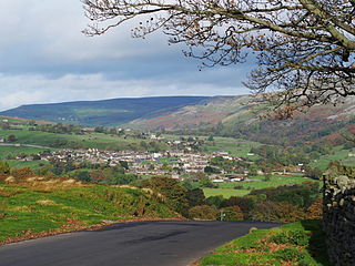
Reeth is a village 11 miles (18 km) west of Richmond in the Richmondshire district of North Yorkshire, England, in the civil parish of Reeth, Fremington and Healaugh. Historically part of the North Riding of Yorkshire, it is the principal settlement of upper Swaledale.

Muker is a village and civil parish at the western end of Swaledale in North Yorkshire, England, within the district of Richmondshire.

Great Shunner Fell is the third highest mountain in the Yorkshire Dales, North Yorkshire, England, and the highest point in Wensleydale; at 716 metres above sea level. In clear weather the summit affords views of Wensleydale to the south, Ribblesdale to the south west and Swaledale to the north, as well as views into Cumbria and County Durham beyond the A66.
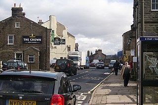
Hawes is a small market town and civil parish in Upper Wensleydale in the Richmondshire district of North Yorkshire, England, that was granted its market charter in 1699. Historically in the North Riding of Yorkshire, Hawes is located at the head of Wensleydale in the Yorkshire Dales; the River Ure runs to the north of the town and is regarded as one of the honeypot tourist attractions of the Yorkshire Dales National Park. It is known as the home to the Yorkshire Wensleydale Cheese.
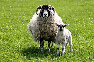
Swaledale is a breed of domestic sheep named after the Yorkshire valley of Swaledale in England. They are found throughout the more mountainous areas of Great Britain, but particularly in the Yorkshire Dales, County Durham, and around the pennine fells of Cumbria.

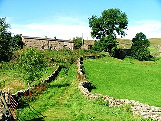
Keld is a village in the English county of North Yorkshire. It is in Swaledale, in the district of Richmondshire and the Yorkshire Dales National Park. The name derives from the Viking word Kelda meaning a spring and the village was once called Appletre Kelde - the spring near the apple trees.

Lovely Seat, originally known as Lunasett until being misnamed by map makers some time in the twentieth century, is a fell in the Yorkshire Dales National Park in North Yorkshire, England. It reaches a height of 675 metres (2,215 feet). It is situated at grid reference SD878950 three miles north of the town of Hawes, and is part of the high ground which separates Wensleydale from Swaledale. It is the highest point of Abbotside Common. The fell is separated from its neighbour to the west, Great Shunner Fell, by the Buttertubs Pass which carries the minor motor road between Hawes in Wensleydale and Thwaite in Swaledale. The name Lunasett derives from the Norse dialect moon pasture; Commoners of Abbotside still use the original name.

Thwaite is a small village in the Yorkshire Dales, North Yorkshire, England. It is in Swaledale and is part the district of Richmondshire and the civil parish of Muker. The village lies on the B6270 road that runs through Swaledale from east to west and is 9.3 miles (15 km) west of Reeth. The name "Thwaite" comes from the Old Norse word þveit, meaning 'clearing, meadow or paddock'.
Angram is a hamlet in the Yorkshire Dales in the Richmondshire district of North Yorkshire, England. It is situated near to Keld to the north and Thwaite to the south. Angram forms part of the civil parish of Muker.

Burtersett is a small village in the Yorkshire Dales, North Yorkshire, England. It lies approximately 1 mile (1.6 km) east from Hawes and Gayle.
The Swaledale Festival takes place over two weeks in May and June each year, in churches, chapels, castles, ‘Literary Institutes’, pubs, fields and village halls scattered around Swaledale, Arkengarthdale and Wensleydale. The largest venues seat about 400 people; the smallest venues as few as 40. The main focus of the Festival is on small-scale classical chamber music. Choral music, folk music, brass bands and jazz also feature, as do talks, films, exhibitions, poetry readings, workshops and guided walks. The 2014 Festival featured Royal Northern Sinfonia, Natalie Clein, Nicholas Daniel, Don Paterson, Emma Johnson, Martin Taylor, Martin Simpson and the Navarra Quartet, among others.

Coverdale is a dale in the far east of the Yorkshire Dales, North Yorkshire, England. It takes its name from the River Cover, a tributary of the River Ure. The dale runs south-west from the eastern end of Wensleydale to the dale head at a pass, known as Park Rash Pass, between Great Whernside to the south and Buckden Pike to the north. It is accessible by a single track road, which runs the length of the dale and over the pass to Kettlewell in Wharfedale. Speight suggests that the name derives from the Anglo-Saxon Cofa-Dal which means Cave-Dale or it may derive from Kofur which means Arrow; an allusion to the swiftness of the water in the dale.

Swaledale is a full fat hard cheese produced in the town of Richmond in Swaledale, North Yorkshire, England. The cheese is produced from cows’ milk, Swaledale sheep's milk and goats’ milk.

Birks Fell is a hill in the Yorkshire Dales, near to Hubberholme in North Yorkshire, England. It is classed as a Marilyn. Birks Fell only became an official Marilyn in 2006 as it was resurveyed and discovered to be 610 metres (2,001 ft) and not 608 metres (1,995 ft) as previously thought. Books from the late 19th and early 20th centuries list the hill as being 2,001 feet (610 m) and it is thought that in the conversion to metric, the hill lost some height. This raises it above neighbouring Horse Head Moor, making it the Marilyn in place of Horse Head Moor.


