Related Research Articles
Highway 3A is the designation of two segments of highway in the southern part of British Columbia.
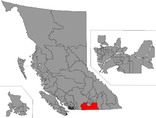
Yale-Lillooet was a provincial electoral district for the Legislative Assembly of British Columbia, Canada.
Hedley is an unincorporated community near the mouth of Hedley Creek in the Similkameen region of southern British Columbia. The former mining town, on BC Highway 3, is by road about 74 kilometres (46 mi) southwest of Penticton and 38 kilometres (24 mi) southeast of Princeton.
Boundary-Similkameen is a provincial riding formed in 2008. It includes the populations of Penticton-Okanagan Valley, West Kootenay-Boundary and Yale-Lillooet. The riding's name corresponds to that of a former riding in the same area, with similar but not identical boundaries.
Okanagan-Boundary was a provincial electoral district in the Canadian province of British Columbia spanning the area from the Similkameen towns of Kaleden and Keremeos to Grand Forks and Christina Lake, and including the southern Okanagan towns of Okanagan Falls, Oliver, Osoyoos, Rock Creek and Greenwood. The riding first appeared in the 1991 election as the result of a redistribution of the former riding of Boundary-Similkameen. The same area is now part of West Kootenay-Boundary.

Keremeos is a village in the Southern Interior of British Columbia, Canada. The name originated from the Similkameen dialect of the Okanagan language word "Keremeyeus" meaning "creek which cuts its way through the flats" referring to Keremeos Creek which flows down from the Upper Benchlands to the Similkameen River that runs by the village.

Cathedral Provincial Park and Protected Area, usually known as Cathedral Provincial Park and also as Cathedral Park, is a provincial park in British Columbia, Canada. It is located east of E.C. Manning Provincial Park, south of BC Highway 3, and southeast of the town of Princeton and southwest of Keremeos. Its southern boundary is the border with the United States. Much of the park is the basin of the Ashnola River.
Keremeos Columns Park is a provincial park in British Columbia, Canada. Established in 1931, the park covers a total area of 20 hectares.
The Lower Similkameen Indian Band or Lower Smelqmix, is a First Nations band government in the Canadian province of British Columbia. Their office is located in the village of Keremeos in the Similkameen region. They are a member of the Okanagan Nation Alliance.
The Okanagan Nation Alliance is a First Nations Tribal Council in the Canadian province of British Columbia, spanning the Nicola, Okanagan and Similkameen Districts of the Canadian province of British Columbia and also the Colville Indian Reservation in Washington state of the United States of America.
Franz Xavier Richter, commonly known as Frank Richter, was a pioneer settler, miner and rancher in 19th century Washington and British Columbia.
Francis Xavier Richter Jr. was a Canadian politician, who served as a Member of the Legislative Assembly and Minister of Agriculture and Minister of Mines in the Social Credit government of W.A.C. Bennett in the province of British Columbia. He represented the riding of Similkameen from 1953 to 1966 and its successor riding Boundary-Similkameen from 1966 to 1975.
The Similkameen Country, also referred to as the Similkameen Valley or Similkameen District, but generally referred to simply as The Similkameen or more archaically, Similkameen, is a region roughly coinciding with the basin of the river of the same name in the Southern Interior of British Columbia. The term "Similkameen District" also refers to the Similkameen Mining District, a defunct government administrative district, which geographically encompasses the same area, and in more casual terms may also refer to the Similkameen electoral district, which was combined with the Grand Forks-Greenwood riding by the time of the 1966 election. The Similkameen Country has deep historical connections to the Boundary Country and the two are sometimes considered one region, partly as a result of the name of the electoral district. It is also sometimes classed as being part of the Okanagan region, which results from shared regional district and other administrative boundaries and names. The term "Similkameen District" may also historically refer to the Similkameen Division Yale Land District, which also includes Osoyoos and the Boundary Country to Osoyoos' east.
CIGV-FM is a Canadian radio station, which broadcasts at 100.7 FM in Penticton, British Columbia, with rebroadcasters in Keremeos and Princeton. Founded by The Robinson Family of Great Valleys Radio in 1981, the station was sold to Newcap Radio in 2011, and approved by the CRTC on February 15, 2012. CIGV is the only country format station in the Okanagan Valley and was rebranded to Country 100.7 on April 27, 2012. On May 14, 2012, at 5:30 a.m., 'Okanagan Mornings with Troy Scott and Roo Phelps' went on the air. Troy Scott was released from the company in August 2012 and became Program Director of CJSU-FM. 100.7 re-branded the morning show as "Okanagan Mornings with Roo Phelps." Scott George hosts Okanagan Afternoons.
Olalla is an unincorporated settlement in the South Okanagan region of the Southern Interior of British Columbia, Canada, located southwest of Penticton and just north of Keremeos. Kaleden, just northeast beyond Olalla along BC Highway 3A, occupies the pass dividing the Okanagan Valley beyond and the Similkameen Country of which Olalla is a part.

The Ashnola River is a tributary of the Similkameen River, rising in the northeastern part of the North Cascades in Washington, United States, and flowing north into British Columbia, Canada, to join the Similkameen River about halfway along that river's course between the towns of Princeton and Keremeos. The river crosses the international boundary at 49°00′00″N120°19′37″W and transits Cathedral Provincial Park. It has one main tributary, Ewart Creek, which is about 25 kilometres (16 mi) long and begins virtually at the border and is entirely within Cathedral Park.
Richter Pass is a mountain pass to the south of the summit of British Columbia highway 3 between Keremeos (W) and Osoyoos (E), linking the Similkameen Valley with the South Okanagan over the southernmost end of the Thompson Plateau. The pass is traversed by Old Richter Pass Road and is ~650 m (2,130 ft) in elevation though the name is generally used for the route of Highway 3 as well.
Keremeos Centre is a ghost town located in the Similkameen Country region of British Columbia, Canada. The town is situated on the west side of Keremeos Creek.
Fort Similkameen is the site of a former Hudson's Bay Company fort located in the Similkameen region of British Columbia. The fort was also called Fort Keremeos situated near the Similkameen River close to the City of Keremeos.
References
- ↑ Basque Garnet (1982), British Columbia Ghost Town Atlas. Sunfire Publications Limited.
| | This article about a location in the Regional District of Okanagan-Similkameen, Canada is a stub. You can help Wikipedia by expanding it. |
| | This Canadian ghost town-related article is a stub. You can help Wikipedia by expanding it. |