
Bygland is a municipality in Aust-Agder county, Norway. It is located in the traditional district of Setesdal. The administrative centre of the municipality is the village of Bygland. Other villages in the municipality include Åraksbø, Austad, Byglandsfjord, Grendi, Langeid, Lauvdal, Litveit, Longerak, Moi, Ose, Sandnes, Skåmedal, and Tveit. The Norwegian National Road 9 runs through the municipality, following the river Otra where most of the population of Bygland lives.

Øyarvatnet or Øyarvatn is a lake in Norway. It sits on the border between the municipalities of Valle in Aust-Agder county and Sirdal in Vest-Agder county, about 30 kilometres (19 mi) northeast of the village of Lunde, Sirdal and about 32 kilometres (20 mi) west of Austad in Bygland. The lake is part of the Kvina river system. It is located just to the south of the lake Rosskreppfjorden, which flows into it. The dam at the south end of the 8.05-square-kilometre (3.11 sq mi) lake keeps it at an elevation of 837 metres (2,746 ft).

Rosskreppfjorden is a lake in Norway. The 29.51-square-kilometre (11.39 sq mi) lake lies on the border between the municipalities of Valle and Sirdal. The lake is part of the Kvina river system and has a hydroelectric power plant in a dam on the south end of the lake. The dam keeps the lake at an elevation of about 929 to 890 metres above sea level.
Kolsvatnet is a lake in the municipality of Valle in Aust-Agder county, Norway. It is located about 14 kilometres (8.7 mi) southwest of the village of Valle and about 15 kilometres (9.3 mi) northwest of the village of Rysstad. The lake is located south of the lake Botnsvatnet, east of the mountain Urddalsknuten, and northeast of the lake Rosskreppfjorden. The lake has an area of 2.72 square kilometres (1.05 sq mi) and sits at an elevation of 1,034 metres (3,392 ft) above sea level.
Botnsvatnet or Botsvatnet is a lake in the municipality of Valle in Aust-Agder county, Norway. The 5.61-square-kilometre (2.17 sq mi) lake is located just north of the lakes Rosskreppfjorden and Kolsvatnet and the mountain Urddalsknuten, and it lies to the southeast of the mountain Bergeheii. The village of Valle is located about 14 kilometres (8.7 mi) to the east of the lake. The lake sits at an elevation of 1,020 metres (3,350 ft) above sea level.
Botsvatn or Bossvatn is a lake in the municipality of Bykle in Aust-Agder county, Norway. The 14.6-kilometre (9.1 mi) long, narrow reservoir is located just to the southeast of the large lake Blåsjø and northeast of the lake Ytre Storevatnet. The lake holds water for the Brokke Hydroelectric Power Station, located in nearby Valle municipality. The water from the lake can flow out into the nearby river Otra, but only when water is released from the dam.
Store Bjørnevatn is a lake in the municipality of Valle in Aust-Agder county, Norway. The lake is located in the northern part of the municipality, near the village of Rygnestad, and about 15 kilometres (9.3 mi) north of the municipal center of Valle and about 10 kilometres (6.2 mi) straight east of the village of Bykle in the neighboring municipality. The lake has an area of 2.43 square kilometres (0.94 sq mi) at an elevation of 801 metres (2,628 ft) above sea level.
Straumsfjorden or Straumfjorden is a lake that is located along the border of the municipalities of Bygland and Valle in Aust-Agder county, Norway. The lake has a dam on the south end which discharges into the Hjellevatn lake and eventually travels to the lake Topsæ and the Tovdalselva river drainage basin. The lake sits in the southeastern part of the municipality, about 11 kilometres (6.8 mi) southeast of the village of Rysstad and about 10 kilometres (6.2 mi) northeast of Besteland.

Rygnestad is a village in Valle municipality in Aust-Agder county, Norway. The village is located along the Norwegian National Road 9 in the Setesdal valley. The village lies about 1 kilometre (0.62 mi) east of the river Otra in northern Valle, about 8 kilometres (5.0 mi) south of the lake Store Bjørnevatn. Rygnestad is about 8 kilometres (5.0 mi) north of the village of Valle, the administrative centre of the municipality. The Rygnestadtunet museum is located just north of the village.
Bergeheii is a mountain in the municipality of Valle in Aust-Agder county, Norway. The 1,403-metre (4,603 ft) tall mountain has a topographic prominence of 100 metres (330 ft), making it the 19th highest mountain in Aust-Agder county. The mountain is located in the Setesdalsheiene mountains, about 20 kilometres (12 mi) west of the village of Valle. The lake Rosskreppfjorden lies to the south of the mountain and the lake Botnsvatnet lies to the southeast of the mountain. The mountain Skammevarden lies about 7 kilometres (4.3 mi) northeast of Bergeheii.
Skammevarden is a mountain in the municipality of Valle in Aust-Agder county, Norway. The 1,418-metre (4,652 ft) tall mountain has a topographic prominence of 50 metres (160 ft), making it the 15th highest mountain in Aust-Agder county. It is located in the Setesdalsheiene mountains, about 16 kilometres (9.9 mi) west of the village of Valle and about the same distance south of the village of Bykle.
Skjerkenuten is a mountain in the municipality of Valle in Aust-Agder county, Norway. The 1,404-metre (4,606 ft) tall mountain has a topographic prominence of 70 metres (230 ft), making it the 18th highest mountain in Aust-Agder county. It is located in the Setesdalsheiene mountains, about 18 kilometres (11 mi) west of the village of Valle and about the same distance southwest of the village of Bykle.
Besteland is a village in Valle municipality in Aust-Agder county, Norway. The village is located along the river Otra in the Setesdal valley, about 7 kilometres (4.3 mi) south of the village of Rysstad. The Norwegian National Road 9 runs through the village.
Rysstad is a village in Valle municipality in Aust-Agder county, Norway. The village is located along the river Otra in the Setesdal valley. The Norwegian National Road 9 runs through the village. The village of Besteland lies about 7 kilometres (4.3 mi) to the south and the villages of Brokke and Hovet lie about 3 kilometres (1.9 mi) to the north.

Valle is the administrative centre of Valle municipality in Aust-Agder county, Norway. The village is located in the Setesdal valley, along the river Otra. The village lies along the Norwegian National Road 9, about 160 kilometres (99 mi) north of the city of Kristiansand. The 0.38-square-kilometre (94-acre) village has a population (2016) of 289 which gives the village a population density of 761 inhabitants per square kilometre (1,970/sq mi).
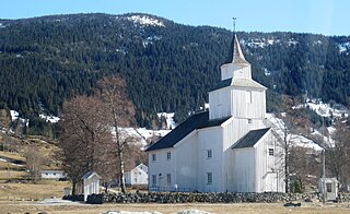
Valle Church is a parish church in Valle municipality in Aust-Agder county, Norway. It is located in the village of Valle. The church is part of the Valle og Hyllestad parish in the Otredal deanery in the Diocese of Agder og Telemark. The white, wooden, cruciform church was built in 1844 by Anders Thorsen Syrtveit using plans by the famous architect Hans Linstow. There have been churches in Valle since the Middle Ages.


