Skelton Glacier is a large glacier flowing from the polar plateau into the Ross Ice Shelf at Skelton Inlet on the Hillary Coast, south of Victoria Land, Antarctica.

Palmer Land is the portion of the Antarctic Peninsula, Antarctica that lies south of a line joining Cape Jeremy and Cape Agassiz. This application of Palmer Land is consistent with the 1964 agreement between the Advisory Committee on Antarctic Names and the UK Antarctic Place-Names Committee, in which the name Antarctic Peninsula was approved for the major peninsula of Antarctica, and the names Graham Land and Palmer Land for the northern and southern portions, respectively. The line dividing them is roughly 69° S.

The Darwin Glacier is a large glacier in Antarctica. It flows from the polar plateau eastward between the Darwin Mountains and the Cook Mountains to the Ross Ice Shelf. The Darwin and its major tributary the Hatherton are often treated as one system, the Darwin–Hatherton.

Shackleton Glacier is a major Antarctic glacier, over 60 nautical miles long and from 5 to 10 nautical miles wide, descending from the Antarctic Plateau from the vicinity of Roberts Massif and flowing north through the Queen Maud Mountains to enter the Ross Ice Shelf between Mount Speed and Waldron Spurs. Discovered by the United States Antarctic Service (USAS) (1939–41) and named by the Advisory Committee on Antarctic Names (US-ACAN) for Sir Ernest Shackleton, British Antarctic explorer.
Cape Darnley is the ice-covered cape forming the northern extremity of Bjerkø Peninsula at the west side of MacKenzie Bay. On December 26, 1929, Sir Douglas Mawson, from the masthead of the RRS Discovery while at 66°57′S71°57′E, saw land miraged up on the southwest horizon. On February 10, 1931, he returned in the Discovery and was able to approach close enough to see the headland, naming it for E.R. Darnley, Chairman of the Discovery Committee of the Colonial Office, London, 1923 to 1933.
Cape Longing is a rocky cape on the east coast of Graham Land, Antarctica, forming the south end of a large ice-covered promontory which marks the west side of the south entrance to Prince Gustav Channel. It was discovered by the Swedish Antarctic Expedition under Otto Nordenskiöld in 1902, and so named by him because from the position of his winter hut on Snow Hill Island the cape lay in the direction of his "land of longing" which he was anxious to explore.
Wilson Hills is a group of scattered hills, nunataks and ridges that extend NW-SE for about 110 kilometres (68 mi) between Matusevich Glacier and Pryor Glacier in Antarctica. They were discovered by Lieutenant Harry Pennell, Royal Navy, on the Terra Nova Expedition in February 1911 during Robert Falcon Scott's last expedition, and named after Edward Adrian Wilson, a zoologist with the expedition, who perished with Scott on the return journey from the South Pole.
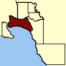
Electoral district of South Melbourne was an electoral district of the Legislative Assembly in the British colony of Victoria (Australia).
Surveyors Range is a 30 miles (48 km) long mountain range in the Churchill Mountains of Antarctica.

Il Polo Glacier is a small glacier draining northward between Polar Times Glacier and Polarforschung Glacier into the Publications Ice Shelf, Antarctica. It was delineated in 1952 by John H. Roscoe from air photos taken by U.S. Navy Operation Highjump, 1946–47, and was named by Roscoe for Il Polo, a polar journal published by the Istituto Geografico, Forlì, Italy.
The Lazarev Ice Shelf is that part of the ice shelf fringing the Princess Astrid Coast of Queen Maud Land, Antarctica, that lies between Leningradskiy Island and Verblyud Island. It is part of the western Riiser-Larsen Sea and is about 50 nautical miles (90 km) long, with Razlom Point at its western edge. The ice shelf was first photographed from the air and mapped by the Third German Antarctic Expedition, 1938–39. It was explored and mapped by the Soviet Antarctic Expedition in 1959, and named for Lieutenant Mikhail P. Lazarev, commander of the sloop Mirnyy.
The Copperneedle River originates within the northern Hearne Domain, Western Churchill province of the Churchill craton, the northwest section of the Canadian Shield in Nunavut's Kivalliq Region. There are rapids along the river, approximately 15 km (9.3 mi) from Hudson Bay's Dawson Inlet.

Boorowa River, a perennial stream that is part of the Lachlan catchment within the Murray–Darling basin, is located in the central–western region of New South Wales, Australia.
The Waiotaka River is a river of the Waikato Region of New Zealand's North Island. It flows northwest from its origins in the Kaimanawa Range to reach the southern shore of Lake Taupō 5 kilometres (3 mi) northeast of Tūrangi.

Nicholson Peninsula is a broad ice-covered peninsula about 15 nautical miles (28 km) long, between Couzens Bay and Matterson Inlet on the Shackleton Coast on the west side of the Ross Ice Shelf, Antarctica.
Tumble Glacier is a glacier extending along the east side of Alexander Island, Antarctica, 7 nautical miles (13 km) long and 3 nautical miles (6 km) wide, which flows east from the cliffs of Mount Egbert, Mount Ethelwulf and Mount Ethelred of the Douglas Range into the west side of the George VI Ice Shelf that occupies George VI Sound immediately south of Mount King. The glacier was first roughly surveyed in 1936 by the British Graham Land Expedition under Rymill. Resurveyed in 1948 by the Falkland Islands Dependencies Survey, and so named by them because of the extremely broken condition of the lower reaches of the glacier.
Gough Glacier is an Antarctic glacier about 25 nautical miles (50 km) long, flowing from the northern slopes of the Prince Olav Mountains and the base of the Lillie Range and trending northward to the Ross Ice Shelf, between the Gabbro Hills and the Bravo Hills. It was named by the Southern Party of the New Zealand Geological Survey Antarctic Expedition (1963–64) for A.L. Gough, surveyor of the party.
Starshot Glacier is a glacier 50 nautical miles (90 km) long that flows through the Churchill Mountains to enter the Ross Ice Shelf in Antarctica.

Amanda Bay, also sometimes known as Hovde Cove, lies in southern Prydz Bay on the Ingrid Christensen Coast of Princess Elizabeth Land, East Antarctica. It is best known for its breeding colony of several thousand pairs of emperor penguins on sea ice at the south-west corner of the bay.
 This article incorporates public domain material from "Uragannyy Point". Geographic Names Information System . United States Geological Survey.