Urban evolution of colonial Quito

Last updated

In almost three centuries of the Spanish Colonization Period, close to one thousand cities were founded in the Americas. These new towns were built in accordance to several legislative documents that were given by the Spanish Crown to regulate, among many other aspects in the American Colonies, the creation of new settlements. In order to assure a long lasting presence of the Spanish Crown, the command given to the Conquistadors was that the settlements were to be permanent so they could have a strategic role in the discovery, conquest and administration of the new world. [1]

Contents

Quito is one of the cities founded by the Spanish. It was located 2800 meters above sea level in a territory previously occupied by an indigenous population. One of the advantages this place offered was that, due to the complicated topography of creeks and mountains, it had favorable conditions for defending the city against a possible uprising of the aboriginal inhabitants. [1]

Quito Capital city in Pichincha, Ecuador

Quito is the capital and the largest city of Ecuador, and at an elevation of 2,850 metres (9,350 ft) above sea level, it is the second-highest official capital city in the world, after La Paz, and the one which is closest to the equator. It is located in the Guayllabamba river basin, on the eastern slopes of Pichincha, an active stratovolcano in the Andes Mountains.

Foundation

First graphic of the layout of Colonial Quito First graphic of the layout of Colonial Quito.jpg
First graphic of the layout of Colonial Quito

It is not certain if Quito had a foundational plan as it was recommended by the Spanish Crown for every new settlement. However, its founders surely followed and adapted the instructions to the complicated terrain where they settled. All works had to start by the establishment of the Main Plaza and then extend the square grid and the streets so they would connect to gates and main roads leaving enough space for the growth of a future population. [1] The regularity of the Damero, as the square Spanish Grid was called, was broken by the creeks and elevations existing in this site. The blocks had to be made smaller and many of them rectangular when cut by a creek. Despite the efforts of the settlers to adapt this system to the site, many of the streets and allotments turned out having a very steep slope. This characteristic became one of the peculiarities of this Historical Center.

Human settlement Community of any size, in which people live

In geography, statistics and archaeology, a settlement, locality or populated place is a community in which people live. The complexity of a settlement can range from a small number of dwellings grouped together to the largest of cities with surrounding urbanized areas. Settlements may include hamlets, villages, towns and cities. A settlement may have known historical properties such as the date or era in which it was first settled, or first settled by particular people.

There is no clear consensus over the shape of the original allotments since the first plan that included this information was only published by 1887 by Gualberto Pérez, over three hundred years after the foundation. However, some studies suggest that every block was divided in eight allotments of 55 by 110 foot [2] and that there were around three hundred houses in the city. [3]

The Development Era

Plan Created by Dionisio Alcedo y Herrera and Found in the Archive of Indies. 1734 Plan of the City of Quito.jpg
Plan Created by Dionisio Alcedo y Herrera and Found in the Archive of Indies.

The first graphical representation of the layout of the city is an anonymous draft dated 1573 made for the Spanish Crown. It situates the main elements of the city, but most of them are misplaced. It is believed that the author was drafting by memory once he went back to Spain. [4] In this plan, the city did not exceeded six by five blocks and it is believed to represent the shape of the city before 1569 since some elements added after this date are not included in this draft.

Spain Kingdom in Southwest Europe

Spain, officially the Kingdom of Spain, is a country mostly located in Europe. Its continental European territory is situated on the Iberian Peninsula. Its territory also includes two archipelagoes: the Canary Islands off the coast of Africa, and the Balearic Islands in the Mediterranean Sea. The African enclaves of Ceuta, Melilla, and Peñón de Vélez de la Gomera make Spain the only European country to have a physical border with an African country (Morocco). Several small islands in the Alboran Sea are also part of Spanish territory. The country's mainland is bordered to the south and east by the Mediterranean Sea except for a small land boundary with Gibraltar; to the north and northeast by France, Andorra, and the Bay of Biscay; and to the west and northwest by Portugal and the Atlantic Ocean.

When in 1563 King Philip II raised the City of Quito to Royal Audience, new infrastructure was built to house the growing population. Bridges were created over the creeks that crossed through the city and, later, they were piped and leveled to generate more space for dwellings and streets. [1] The original topography of the city was changed allowing more people to populate a bigger area. This started the period of biggest expansion the city knew for several centuries.

Philip II of Spain 16th-century King of Spain who became King of England by marriage

Philip II of Spain was King of Castile and Aragon (1556–98), King of Portugal, King of Naples and Sicily, and jure uxoris King of England and Ireland. He was also Duke of Milan. From 1555 he was lord of the Seventeen Provinces of the Netherlands.

Infrastructure fundamental facilities and systems serving a country, city, or other areas

Infrastructure is the fundamental facilities and systems serving a country, city, or other area, including the services and facilities necessary for its economy to function. Infrastructure is composed of public and private physical improvements such as roads, bridges, tunnels, water supply, sewers, electrical grids, and telecommunications. In general, it has also been defined as "the physical components of interrelated systems providing commodities and services essential to enable, sustain, or enhance societal living conditions".

Topography The study of the shape and features of the surface of the Earth and other observable astronomical objects

Topography is the study of the shape and features of land surfaces. The topography of an area could refer to the surface shapes and features themselves, or a description.

Over two hundred years had to pass until another plan of the city was drafted. In 1734, Dionisio Alcedo y Herrera, President of the Tribunal of the Royal Audience of Quito, created a representation of the layout of the city that showed that Quito had grown over three times its original size and that showed how it had extended especially to the North and South. This was the period of the biggest and most rapid growth of Colonial Quito [5] (Barrera, 1922). All the Plazas, Monasteries and most of the streets that are shown in this map, are kept until the current days. This plan also skillfully incorporates the elevations of the buildings and it is clear that most of them have not changed ever since.

The Stagnation Era

Plan Created by the Academy of Sciences of Paris and Found in the British Library. 1736 French Draft of the Plan of Quito.jpg
Plan Created by the Academy of Sciences of Paris and Found in the British Library.

When scientists from the French Academy of Sciences arrived to Quito, by 1736 they created what is probably the first modern representation of the plan of the city in terms of technique, scale and proportion. They calculated that the city had between fifty and sixty thousand inhabitants and it is clear that by this moment most of what today is the Historic Center of Quito had been built. [6] This plan was reproduced and adapted in a series of publications in France and Spain; however there were no new measurements made until a century later.

Until the end of the 18th Century, the population of the city would decline due to earthquakes, volcanic eruptions, famines, economic crisis, plagues, bad sanitary conditions, poor medical attention, among other factors. [1] It was calculated in 1757 by the Italian Jesuit Juan Bautista Coleti that the population was between 46000 and 48000 inhabitants. During this time there was no urban expansion and many of the houses in the outskirts of the city were reported to have turned into ruins since almost a quarter of the population was lost or left the city.

The end of the colonial period

Of Unknown Author it was property of Juan Pio Montufar. 1810 Plan of San Francisco of Quito.jpg
Of Unknown Author it was property of Juan Pío Montúfar.

In all the new plans that represented Quito there was no evidence of growth in population or area. It was not until 1810 that this could be seen in a map. It is believed that this representation of the city was property of Juan Pío Montúfar, II Marquis of Selva Alegre, but it has no known author. It is an adaptation of the maps made by the French Academy of Sciences, but it incorporated new elements created over the last century. [1] It is clear in this map that the city had grown towards the mountains to the East and West, but the limits in the north and south did not have any significant changes. This map is the last colonial representation of the urban form of Quito. After 1809 several uprisings and military battles led Quito to its independence and years after it became the Capital of Ecuador.

The colonial period had ended and the new Republic started. The costs of war, political instability and economic crisis caused a very slow recovery and growth for this City. However, it may have been because of these same limitations that the City was preserved in its previous glory that centuries later gave it the acknowledgement by the UNESCO as a World Heritage Site.

Related Research Articles

The History of Ecuador extends over an 8,000-year period. During this time a variety of cultures and territories influenced what has become the Republic of Ecuador. The history can be divided into six eras: Pre-Columbian, the Conquest, the Colonial Period, the War of Independence, Gran Colombia, and Simón Bolívar the final separation of his vision into what is known today as the Republic of Ecuador.

New Spain viceroyalty of the Spanish Empire (1535-1821)

The Viceroyalty of New Spain was an integral territorial entity of the Spanish Empire, established by Habsburg Spain during the Spanish colonization of the Americas. It covered a huge area that included territories in North America, South America, Asia and Oceania. It originated in 1521 after the fall of Mexico-Tenochtitlan, the main event of the Spanish conquest, which did not properly end until much later, as its territory continued to grow to the north. It was officially created on 8 March 1535 as a viceroyalty, the first of four viceroyalties Spain created in the Americas. Its first viceroy was Antonio de Mendoza y Pacheco, and the capital of the viceroyalty was Mexico City, established on the ancient Mexico-Tenochtitlan.

Viceroyalty of Peru Spanish Imperial colony

The Viceroyalty of Peru was a Spanish imperial provincial administrative district, created in 1542, that originally contained modern-day Peru and most of Spanish-ruled South America, governed from the capital of Lima. The Viceroyalty of Peru was one of the two Spanish Viceroyalties in the Americas from the sixteenth to the eighteenth centuries.

Nicoya Town in Guanacaste Province, Costa Rica

Nicoya, a city on the Nicoya Peninsula of the Guanacaste province, Costa Rica, is one of the country's most important tourist zones; it serves as a transport hub to Guanacaste's beaches and national parks. According to the 2000 census, the city's population was 13,334; second in the province only to Liberia. The city is the district seat of a cantón of the same name, which in 2013 had 24,946 residents.

The Real Audiencia, or simply Audiencia, was an appellate court in Spain and its empire. The name of the institution literally translates as Royal Audience. The additional designation chancillería was applied to the appellate courts in early modern Spain. Each audiencia had oidores.

Eugenio Espejo writer, lawyer, physician

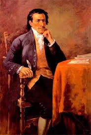
Francisco Javier Eugenio de Santa Cruz y Espejo was a medical pioneer, writer and lawyer of mestizo origin in colonial Ecuador. Although he was a notable scientist and writer, he stands out as a polemicist who inspired the separatist movement in Quito. He is regarded as one of the most important figures in colonial Ecuador. He was Quito's first journalist and hygienist.

Décima ten-line stanza of poetry

A décima is a ten-line stanza of poetry, and the song form generally consists of forty-four lines. It is also called "espinela" after its founder, Vicente Espinel (1550–1624), a Spanish writer and musician of the Siglo de Oro.

Ecuadorian War of Independence armed conflict in Ecuador between 1820 and 1822

The Ecuadorian War of Independence was fought from 1820 to 1822 between several South American armies and Spain over control of the lands of the Royal Audience of Quito, a Spanish colonial administrative jurisdiction from which would eventually emerge the modern Republic of Ecuador. The war ended with the defeat of the Spanish forces at the Battle of Pichincha on May 24, 1822, which brought about the independence of the entire Presidencia de Quito. The Ecuadorian War of Independence is part of the Spanish American wars of independence fought during the first two decades of the 19th century.

Lands administrative divisions of Australia

Lands administrative divisions of Australia are the cadastral divisions of Australia for the purposes of identification of land to ensure security of land ownership. Most states term these divisions as counties, parishes, hundreds, and other terms. The eastern states of Queensland, New South Wales, Victoria and Tasmania were divided into counties and parishes in the 19th century, although the Tasmanian counties were renamed land districts in the 20th century. Parts of South Australia (south-east) and Western Australia (south-west) were similarly divided into counties, and there were also five counties in a small part of the Northern Territory. However South Australia has subdivisions of hundreds instead of parishes, along with the Northern Territory, which was part of South Australia when the hundreds were proclaimed. There were also formerly hundreds in Tasmania. There have been at least 600 counties, 544 hundreds and at least 15,692 parishes in Australia, but there are none of these units for most of the sparsely inhabited central and western parts of the country.

Iglesia y Convento de San Francisco, Quito church building in Quito, Ecuador

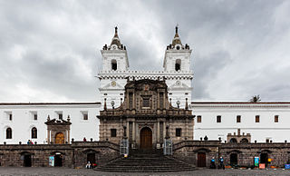
The Church and Monastery of St. Francis, commonly known as el San Francisco, is a 16th-century Roman Catholic complex in Quito, Ecuador. It fronts onto its namesake Plaza de San Francisco. The imposing structure has the distinction of being the largest architectural ensemble among the historical structures of colonial Latin America and for this reason is sometimes known as "El Escorial of the New World". The style evolved over almost 150 years of construction (1534-1680) through earthquakes and changes in artistic fashion. The Church houses the city's beloved Virgin of Quito (1734).

Quito School

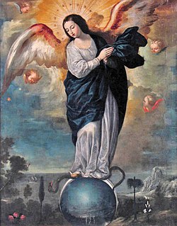
The Quito School is a Latin American artistic tradition that constitutes essentially the whole of the professional artistic output developed in the territory of the Royal Audience of Quito — from Pasto and Popayán in the north to Piura and Cajamarca in the south — during the Spanish colonial period (1542-1824). It is especially associated with the 17th and 18th centuries and was almost exclusively focused on the religious art of the Catholic Church in the country. Characterized by a mastery of the realistic and by the degree to which indigenous beliefs and artistic traditions are evident, these productions were among of the most important activities in the economy of the Royal Audience of Quito. Such was the prestige of the movement even in Europe that it was said that King Carlos III of Spain (1716–1788), referring to one of its sculptors in particular, opined: "I am not concerned that Italy has Michelangelo; in my colonies of America I have the master Caspicara".

Eduardo Estrella Aguirre was an Ecuadorian doctor and researcher who published Flora Huayaquilensis: The Botanical Expedition of Juan Tafalla 1799-1808.

Nina Pacari Ecuadorian politician and judge

Nina Pacari, born as María Estela Vega Conejo is a Kichwa politician, lawyer and indigenous leader from Ecuador.

National Order of San Lorenzo

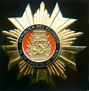
The National Order of San Lorenzo was established as a military order medal by the President of the First Revolutionary Government of Quito, Juan Pío Montúfar, II Marquis de Selva Alegre, by a decree issued on August 17, 1809, in the Capitulate Hall of the Convent of San Agustín. All the members of the revolutionary Council were decorated with it. Once the Council disappeared and the power returned to Spanish hands, the Order also ceased for more than a century.

Pomasqui Valley

Pomasqui Valley is a valley on the northern outskirts of Quito, Ecuador. It is located on the equator, the so-called "Mitad del Mundo", at an altitude of around 2,600 metres (8,500 ft) above sea level. Hot and semi-arid, it is formed by a river tributary. The valley contains the Cerro de Catequilla, which contains the pre-Columbian astronomical observatory, Catequilla. The village of Pomasqui itself lies roughly 6 kilometres (3.7 mi) from the equator. The Monjas River flows nearby and the valley is an important centre for viniculture in Ecuador, with vineyards. The economy features vegetable and fruit production. To the northwest is the Pululahua Geobotanical Reserve.

Acala Chʼol

The Acala Chʼol were a former Chʼol-speaking Maya people who occupied a territory to the west of the Manche Chʼol and east of the Chixoy River in what is now the Alta Verapaz Department of Guatemala. The Acala should not be confused with the people of the former Maya territory of Acalan, near the Laguna de Terminos in Mexico.

The following is a timeline of the history of the city of Quito, Ecuador.

Quilago (1485–1515) was a chieftainess or queen regnant of the Cochasquí in Ecuador, famed for her defense of the Cochasquí against the expansion of the Inca Empire.

Indochristian art

Indochristian art, or arte indocristiano, is a type of Latin American art that combines European colonial influences with Indigenous artistic styles and traditions.

María Luisa Gómez de la Torre Páez was an Ecuadorian feminist, educator, and activist. She was a pioneer in the struggle for the rights of the indigenous peoples and peasants in Ecuador. She was the first woman to serve as a teacher for boys in Quito.

References

  1. 1 2 3 4 5 6 Ortiz, Alfonso (2007). Damero. Quito: FONSAL.
  2. Schottelius, Justus Wolfran (1941). La Fundación de Quito. Plan y Construcción de una Ciudad Colonial Hispanoamericana. Quito: Archivo Municipal de Quito.
  3. Ponce Leiva, Pilar (1992). Descripción de la ciudad de San Francisco de Quito. Quito: Abya Yala.
  4. Estupiñán, Tamara (1984). "El Plano Conocido Más Antiguo de Quito". Revista Trama. 33.
  5. Barrera, Isaac (1992). Quito Colonial. Siglo XVIII Comienzos del Siglo XIX. Quito: Academia Nacional de Historia.
  6. La Fuente, Antonio (1992). Los Caballeros del Punto Fijo. Quito: Abya Yala.