Vitosha, the ancient Scomius or Scombrus, is a mountain massif, on the outskirts of Sofia, the capital of Bulgaria. Vitosha is one of the symbols of Sofia and the closest site for hiking, alpinism and skiing. Convenient bus lines and rope ways render the mountain easily accessible. Vitosha has the outlines of an enormous dome. The territory of the mountain includes Vitosha nature park that encompasses the best known and most frequently visited parts. The foothills of Vitosha shelter resort quarters of Sofia; Knyazhevo quarter has mineral springs. Vitosha is the oldest nature park in the Balkans. The mountain emerged as a result of volcanic activity and has been subsequently shaped by the slow folding of the granite rock layers and a series of gradual uplifts of the area. It appears dome shaped at first sight, but the mountain, 19 km long by 17 km wide, actually consists of concentric denudational plateaus rising in tiers one above the other. Vitosha is separated into four main parts whose main ridges gather at a crown known as Cherni Vrah. This is the highest point of the mountain at 2290 m and is one of 10 peaks of Vitosha over 2000 m in height. It is the highest massif of Srednogorie mountain chain system, together with Sredna gora, Plana (mountain), Lyulin Mountain, Greben (mountain), Viskyar Mountain, etc. They all are a result of the folding of the earth layers through the Mesozoic, causing also magma sheet-like intrusion that has been injected between layers of sedimentary rock. The lacolithic domed form of Vitosha is a typical example.

The Iskar is a right tributary of the Danube. With a length of 368 km it is the longest river that runs entirely within Bulgaria. Originating as three forks in Balkan's highest mountain range Rila, it flows in northern direction until its confluence with the Danube River. As it flows northwards it fuels the largest artificial lake in the country, the Iskar Reservoir, forms the divide between the Vitosha and Plana Mountains in the west and the Sredna Gora mountain range in the east before entering the Sofia Valley, which contains the nation's capital Sofia. From there the Iskar runs through the Balkan Mountains forming the spectacular 84 km long Iskar Gorge and as it crosses the mountains its water course turns in north-eastern direction at Lakatnik. North of the Balkan Mountains the river crosses the Danubian Plain and finally flows into the Danube between the villages of Baykal and Gigen. Geologically, Iskar is the oldest river in the Balkan Peninsula.
Bistritsa or Bistrica may refer to:
Boyana is a neighbourhood of the Bulgarian capital of Sofia, part of Vitosha municipality and situated 8 km south of the city centre, in the outskirts of Vitosha. Boyana is one of the most expensive parts of Sofia to live in. The residents are primarily wealthy business people, government officials and other prominent members of Bulgarian society. Formerly an outlying village, it was incorporated into Sofia in 1961.
The Sofia Valley is a valley in central western Bulgaria, bordering Stara Planina to the northeast, the Viskyar, Lyulin, Vitosha and Lozen mountains to the southwest, the Vakarel Mountain to the southeast and the low Slivnitsa Heights to the northwest.

The Vladayska is a river in western Bulgaria, a tributary of the Perlovska.
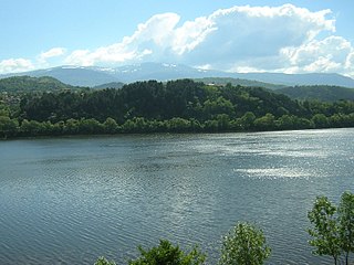
Lake Pancharevo is an artificial lake in western Bulgaria, at the end of the Pancharevo Gorge of the Iskar River, located at 600 m above sea level between the Vitosha and Lozenska mountains. It is 3 km long and up to 700 m wide, reaching a depth of 30 m, and is situated 12 km southeast of the capital city of Sofia, where the Vitoshka Bistritsa flows into the Iskar. The villages of Pancharevo and Kokalyane and the Pancharevo mineral springs lies on the lake's western shore, while at the southern end of the lake there is a hydroelectric power station. Sports centres and catering establishments have been constructed around the lake, making it a favoured outing location for the residents of Sofia. Further upstream in the gorge there are two additional artificial lakes: the Pasarel Reservoir and the Iskar Reservoir.

Pancharevo is a resort village and district located on the outskirts of Sofia close to Vitosha, Lozenska and Plana mountains and occupies the southeastern part of the Capital Municipality. As of 2011 the village has 3,433 inhabitants, but the district about 28,000. It is the largest region in Sofia with total area of 364,7 km². It includes the largest artificial lake in Bulgaria Lake Pancharevo, also as Iskar Reservoir and Pasarel Reservoir, located one above the other. The districts consists of 10 villages, and Pancharevo is the municipal seat:
Vladaya is a village situated on the Vitosha and Lyulin mountains in western Bulgaria at an altitude of about 1000 m. In the 2011 census in Vladaya were counted 4043 residents, which makes it the 10th-largest village in Bulgaria.

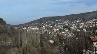
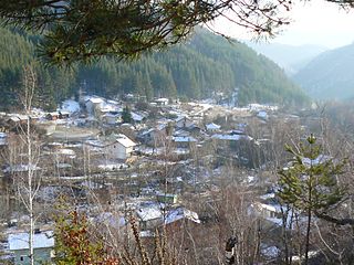
Bistritsa is a large village in the Pancharevo municipality, located at 15 km to the south of the capital Sofia. As of 2006 it has 4,004 inhabitants.

Bistritsa or Vitoshka Bistritsa, is a river in western Bulgaria, tributary of Iskar River. Flows from the eastern slopes of Golyam Rezen Peak on Vitosha Mountain, crossing Bistrishko Branishte Nature Reserve, where it forms a small but beautiful waterfall Samokovishteto, then crossing villages of Bistritsa and Pancharevo to flow into Lake Pancharevo, near Sofia. Additional charm of the area offer several artificial waterfalls in the lower reaches of the river.

Golyam Rezen is a peak on Vitosha Mountain in Bulgaria. Rising to 2,277 m, the peak is second to the mountain's summit Cherni Vrah situated 900 m to the west. Golyam Rezen hosts an Air Traffic Services facility, as well as military communications installations. The precipitous east slopes of the peak are a popular rock climbing site, overlooking Bistritsa River Valley in Bistrishko Branishte Biosphere Reserve.
Chuypetlovo is a village in the Pernik municipality of Pernik Province, western Bulgaria. Its population is 57 as of January 2007.

Plana is a mountain in western Bulgaria, bounded by Sofia Valley to the north, Iskar River to the east, Samokov Valley to the south and southwest, and Vitosha Mountain to the northwest. The summit Manastirishte rises to 1338m.
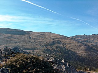
Skoparnik is the third highest peak of Vitosha Mountain in Bulgaria. Rising to 2,226 m, the peak is situated 1.5 km south of Golyam Rezen Peak (2,277 m), and 2 km southeast of the summit Cherni Vrah (2,290 m). The peak is bounded by the Bistrishko Branishte Biosphere Reserve to the east, and a prohibited drinking water catchment area to the west, and is part of the divide between the Black Sea and the Mediterranean, with the Vitoshka Bistritsa draining its eastern slopes to flow into the Iskar River and eventually to the Danube River, and the Struma River draining the western slopes to flow into the Aegean Sea.

Urvich Wall is the narrow ice-free and crescent-shaped ridge rising to 121 m on Livingston Island in the South Shetland Islands, Antarctica and bounded by Nedelya Point to the north and Rish Point to the southeast. Extending 6.7 km and up to 400 m wide, the ridge separates Byers Peninsula to the west from Rotch Dome to the east.
Pancharevo Gorge is a deep and narrow gorge in the upper stream of the Iskar River in western Bulgaria. It is sandwiched between the mountains of Vitosha and Plana to the southwest and the Lozen Mountain to the northeast. The gorge forms the boundary between Samokov and Sofia valleys. Its average altitude is 700 m. The villages of Pancharevo, Kokalyane and Dolni Pasarel also located in the gorge. In the narrowest part of the gorge Iskar River makes a meander in which right beach is located Urvich medieval fortress, and in the left - Kokalyane monastery. In the gorge are situated the Pancharevo Lake and the Pasarel Reservoir.

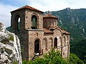
Kokalyane is a village in the municipality of Sofia, in the district of Pancharevo. As of 2007 it has 1,859 residents. The village is situated at the foothills of the Vitosha mountain, 18 km from the center of Sofia. The ruins of the Urvich fortress, connected with the fall of the Bulgarian Empire to the Ottomans in the end of the 14th century and the legends about the last Emperor Ivan Shishman, are located in the vicinity of the village.
The Stolichna Municipality is an obshtina (municipality) in Sofia City Province, Western Bulgaria. It is named after its administrative centre - the city of Sofia, which is also the capital of Sofia City Province and Sofia Province and the capital of Bulgaria as well.

Lozen Mountain is a small mountain in Bulgaria. It is at the westernmost end of the Sredna Gora range. To the west, it is separated by the Pancharevo Gorge from the Vitosha and Plana mountains. To the north, its foothills descend into the Sofia Valley. The mountain extends for 15 kilometres (9.3 mi) in an east-west direction, while its width varies between 5 kilometres (3.1 mi) and 10 kilometres (6.2 mi). Its highest point is Popov Dyal, 1,190.2 metres (3,905 ft). It is named after the village of Lozen.