| Usangu Plain | |
|---|---|
 | |
| Geography | |
| Country | Tanzania |
| State/Province | Iringa, Mbeya |
| Coordinates | 8°34′S34°12′E / 8.56°S 34.2°E |
The Usangu Plain is a lowland in south-central Tanzania. It is named for the Sangu people.
| Usangu Plain | |
|---|---|
| | |
| Geography | |
| Country | Tanzania |
| State/Province | Iringa, Mbeya |
| Coordinates | 8°34′S34°12′E / 8.56°S 34.2°E |
The Usangu Plain is a lowland in south-central Tanzania. It is named for the Sangu people.
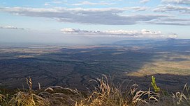
The Usangu Plain covers an area of 15,500 km2. It extends northeast-southwest, bounded on the south by the Udzungwa Mountains, and the Kipengere Range on the southwest. Between the two ranges the Makambako Gap opens to the south. On the north, The Mbeya Mountains rise steeply to the northwest, and the lower Lupa upland further to the east. Further east the Usangu escarpment becomes less distinct, and the plain transitions into the plateau of central Tanzania. [1]
The plain is drained by the Great Ruaha River and its tributaries.
The Usangu Plain is the eastern branch of the East African Rift. The Usangu Fault scarp runs along the northern edge of the plain, where the Mbeya Mountains and Lupa upland meet the plain. The Chimala fault scarp marks the southern edge of the Usangu basin, defining the northern edge of the Kipengere and Udzungwa mountains. [1]
Most of the region is in the Southern Acacia-Commiphora bushlands and thickets ecoregion, with extensive grasslands punctuated by woodlands of Acacia and Commiphora trees. [2] There are areas of dry miombo woodland along the southern end of the plain, on the lower slopes of the plateaus and the Makambako Gap.
The Great Ruaha River forms extensive wetlands, some seasonal, in the middle of the plain.
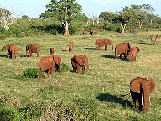
Ruaha National Park occupies the eastern and central portion of the plain.
Until the 1960s, the Sangu people were mostly pastoralists, grazing cattle on the plain with a communal form of land ownership. The Sangu were concentrated in the southern part of the plain, which was more amenable to cattle grazing. In the 1960s the Tanzanian government organized an irrigation project and developed three large rice farms on the plain, watered by streams originating in the western mountains. Some former communal grazing lands have been brought under state control. Now many Sangu make a living in agriculture. Many people from elsewhere in Tanzania have moved to the region to farm or graze livestock. [3]

The white-throated robin, or irania, is a small, sexually dimorphic, migratory passerine bird. The vernacular and genus name Irania alludes to Iran, its type locality, while the specific name gutturalis is Medieval Latin for "of the throat". It breeds in western Asia and overwinters in East Africa.

Mbeya Region is one of Tanzania's 31 administrative regions. The region covers an area of 35,954 km2 (13,882 sq mi). The region is comparable in size to the combined land area of the nation state of Guinea Bissau. Mbeya Region is bordered to the east by Singida Region, Iringa Region and Njombe Region. The region is bordered to the south by Malawi and Lake Nyasa. To the north the region borders southern Tabora Region. Lastly, Mbeya is bordered to the west by Songwe Region. The regional capital is the city of Mbeya. According to the 2022 national census, the region had a population of 2,343,754.
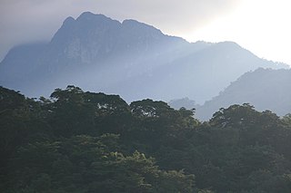
The Kipengere Range, also known as the Livingstone Mountains, lies entirely in Njombe Region in southwest Tanzania at the northern end of Lake Nyasa. Near Lake Nyasa they are known as the Kinga Mountains. It is a plateau-like ridge of mountains running southeastwards from the basin of the Great Ruaha River in the north to that of the Ruhuhu River in the south, and forms part of the eastern escarpment of the East African Rift. The range is mostly clad in montane grasslands, renowned for their botanical diversity and displays of flowers, with montane evergreen forests mostly in stream valleys.
The Udzungwa Mountains are a mountain range in south-central Tanzania. The mountains are mostly within Iringa Region, south of Tanzania's capital Dodoma. The Udzungwa Mountains are part of the Eastern Arc Mountains, and are home to a biodiverse community of flora and fauna with large numbers of endemic species.
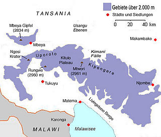
Mount Rungwe is a volcanic mountain in Mbeya Region, in Tanzania's Southern Highlands. At an altitude of 2,981 metres (9,780 ft), it is southern Tanzania's second-highest peak. Rungwe's volcano is currently inactive.

The Eastern Arc Mountains are a chain of mountains found in Kenya and Tanzania. The chain runs from northeast to southwest, with the Taita Hills being in Kenya and the other ranges being in Tanzania. They are delimited on the southwest by the fault complex represented by the Makambako Gap that separates them from the Kipengere Range. To the northeast, they are delimited by more recent volcanism represented by Mount Kilimanjaro. The chain is considered a tentative World Heritage Site.
The Ethiopian montane grasslands and woodlands is a montane grasslands and shrublands ecoregion in Ethiopia. It occupies the middle elevations of the Ethiopian Highlands, between the high-elevation Ethiopian montane moorlands and lowland woodlands, savannas, shrublands, and thickets.
The Southern Highlands is a highland region in southwestern Tanzania, at the northern end of Lake Malawi. The highlands include portions of Mbeya, Njombe, Rukwa, Ruvuma, and Songwe regions, bordering Malawi, Mozambique, and Zambia. Mbeya is the largest city in the highlands.
Mbeya Range is a volcanic mountain range in Mbeya Region, in southwestern Tanzania, East Africa. It forms an arc just north of the town of Mbeya and includes Loleza Peak, Mbeya Peak, Nyanuwa Peak, and Pungulumo. The range is at the junction of the eastern Gregory Rift and western Albertine Rift valleys. and is in Rungwe volcanic province. The Songwe Scarp terminates the Rukwa Trough at its southeast end and forms the northwestern side of the Mbeya Range.

Northern Zanzibar–Inhambane coastal forest mosaic, also known as the Northern Swahili coastal forests and woodlands, is a tropical moist broadleaf forest ecoregion of coastal East Africa. The ecoregion includes a variety of habitats, including forest, savanna and swamps.

The South Malawi montane forest-grassland mosaic is a montane grasslands and shrublands ecoregion of Tanzania, Malawi, Mozambique, and Zambia.
The Rubeho Mountains are a mountain range in central Tanzania. The mountains in Dodoma and Morogoro regions, southeast of Tanzania's capital Dodoma. The Rubeho Mountains are part of the Eastern Arc Mountains, and are home to a biodiverse community of flora and fauna with large numbers of endemic species.

The Southern Acacia–Commiphora bushlands and thickets is a tropical grasslands, savannas, and shrublands ecoregion in Tanzania and Kenya. It includes portions of Serengeti National Park and Ngorongoro Conservation Area, which are designated World Heritage Sites and biosphere reserves for their outstanding wildlife and landscapes. It is one of three Acacia–Commiphora bushlands and thickets ecoregions in eastern Africa.
The Northern Acacia–Commiphora bushlands and thickets are a tropical grasslands, savannas and shrublands ecoregion in eastern Africa. The ecoregion is mostly located in Kenya, extending north into southeastern South Sudan, northeastern Uganda and southwestern Ethiopia and south into Tanzania along the Kenya-Tanzania border.
The Southern Eastern Rift is a freshwater ecoregion in Kenya and Tanzania.

The Somali Acacia–Commiphora bushlands and thickets is a semi-arid tropical grasslands, savannas, and shrublands ecoregion in the Horn of Africa. It is home to diverse communities of plants and animals, including several endemic species.
Acacia–Commiphora bushland is the predominant plant community of northeastern tropical Africa. It occurs in Ethiopia, Kenya, Somalia, South Sudan, and Tanzania.