Related Research Articles

Salt Lake County is located in the U.S. state of Utah. As of the 2020 United States Census, the population was 1,185,238, making it the most populous county in Utah. Its county seat and largest city is Salt Lake City, the state capital. The county was created in 1850. Salt Lake County is the 37th most populated county in the United States and is one of four counties in the Rocky Mountains to make it into the top 100. Salt Lake County is the only county of the first class in Utah - which under the Utah Code is a county with a population of 700,000 or greater.

Bluffdale is a city in Salt Lake and Utah counties in the U.S. state of Utah, located about 20 miles (32 km) south of Salt Lake City. As of the 2020 census, the city population was 17,014.
Riverton is a city in Salt Lake County, Utah, United States. It is part of the Salt Lake City, Utah Metropolitan Statistical Area. The population was 38,753 at the 2010 census, but has since grown to 44,440. Riverton is located in the rapidly growing southwestern corner of the Salt Lake Valley.

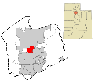
South Jordan is a city in south central Salt Lake County, Utah, United States, 18 miles (29 km) south of Salt Lake City. Part of the Salt Lake City metropolitan area, the city lies in the Salt Lake Valley along the banks of the Jordan River between the 10,000-foot (3,000 m) Oquirrh Mountains and the 11,000-foot (3,400 m) Wasatch Mountains. The city has 3.5 miles (5.6 km) of the Jordan River Parkway that contains fishing ponds, trails, parks, and natural habitats. The Salt Lake County fair grounds and equestrian park, 67-acre (27 ha) Oquirrh Lake, and 27 parks are located inside the city. As of 2020, there were 77,487 people in South Jordan.
Taylorsville is a city in Salt Lake County, Utah. It is part of the Salt Lake City metropolitan area. The population was 60,448 at the time of the 2020 census. Taylorsville was incorporated from the Taylorsville–Bennion CDP and portions of the Kearns metro township on July 1, 1996. The city is located adjacent to Interstate 215 and Bangerter Highway. It is located in the middle of the Salt Lake Valley.
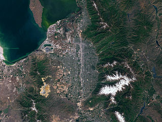
Salt Lake Valley is a 500-square-mile (1,300 km2) valley in Salt Lake County in the north-central portion of the U.S. state of Utah. It contains Salt Lake City and many of its suburbs, notably Murray, Sandy, South Jordan, West Jordan, and West Valley City; its total population is 1,029,655 as of 2010. Brigham Young said, "this is the right place," when he and his fellow Mormon settlers moved into Utah after being driven out of several states.
Glendale is a neighborhood on the West side of Salt Lake City, Utah. Glendale is South of the Rose Park, Fair Park, and Poplar Grove neighborhoods. The neighborhood was originally developed as Glendale Gardens which is where Glendale Middle School derives its name. Mountain View Elementary was originally named Glendale Elementary. Glendale, and neighboring Poplar Grove, Fair Park, & Rose Park enjoy a vibrant multi ethnic environment. Residents of Glendale enjoy the community's diversity, friendliness, pride in community, and authenticity of fellow residents. Those who live in Glendale also cite it as affordable, and conveniently close to local schools, parks, the airport, and downtown Salt Lake City.
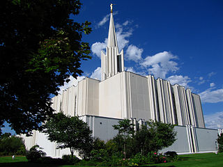
The Jordan River Utah Temple is the 20th operating temple of The Church of Jesus Christ of Latter-day Saints. Located in South Jordan, Utah, it was built with a modern single-spire design.
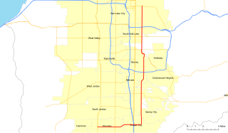
State Route 111 (SR-111) is a state highway in the U.S state of Utah that runs north–south across the west side of the Salt Lake Valley in Salt Lake County. It connects SR-201 in Magna to SR-209 in West Jordan in a span of 10.6 miles (17.06 km). It is known as 8400 West and Bacchus Highway throughout the route's course, in respect of north to south.
The Unified Fire Authority of Greater Salt Lake provides fire protection and emergency medical services for the unincorporated Salt Lake County, Utah as well as for 9 cities located within the Salt Lake Metropolitan Area. These cities include Alta, Cottonwood Heights, Eagle Mountain, Herriman, Holladay, Midvale, Riverton and Taylorsville.
State Route 71 (SR-71) is a state highway completely within the Salt Lake City metropolitan area in the northern portion of the US state of Utah. It runs from SR-154 in the southwest side of the city to SR-186 in Downtown Salt Lake City. The route spans 22.47 miles (36.16 km) as it runs along portions of 12600 South, 12300 South, 900 East, and 700 East streets.

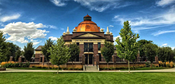
The Oquirrh Mountain Utah Temple is a temple of The Church of Jesus Christ of Latter-day Saints located in South Jordan, Utah, a suburb of Salt Lake City. South Jordan was the first city in the world to have two temples. The temple was the fourth in the Salt Lake Valley and the 13th in the state of Utah.
Jordan School District is a school district in the southwestern portion of Salt Lake County, Utah, United States. It now employs 3,364 teachers and other licensed personnel who educate more than 57,800 students. An additional 3,092 employees provide support services for the system. Jordan District was the largest in Utah until the Canyons School District in the southeastern portion of the county split in 2009. Boundaries for Jordan District now include the communities of Bluffdale, Copperton, Herriman, Riverton, South Jordan and most of West Jordan.

The Jordan River Parkway is an approximately 40-mile (64 km) urban park that runs along the Jordan River within the U.S. state of Utah. The parkway follows along the river from Utah Lake in Utah County, through Salt Lake County and onto the Great Salt Lake in Davis County. The majority of a mixed-use trail has been completed with a shared-use path for cyclists, skaters, and joggers. A separate equestrian path runs on the southern portion of the trail. Many trail-heads, city and county parks and golf courses are also located along the parkway.
Harmons Grocery Company, doing business as Harmons Neighborhood Grocer, is an upscale supermarket chain located within the state of Utah, United States, with 19 stores throughout the Wasatch Front and in the St. George area.
Salt Lake Lutheran High School was a Lutheran school founded in 1984 and located until 2011 in Salt Lake City, Utah, United States. In 2011 the school moved to Riverton, Utah, and took the name Concordia Preparatory School. It closed in 2013.
Utah's 4th congressional district is a congressional district created by the state legislature as a result of reapportionment by Congress after the 2010 Census showed population increases in the state relative to other states. Prior to 2010 reapportionment, Utah had three congressional districts.

The Jordan and Salt Lake City Canal is a 28-mile (45 km) historic waterway in Salt Lake County, Utah, United States.

The East Jordan Canal is a historic waterway in Salt Lake County, Utah, United States.
The South Jordan Canal is an historic waterway in Salt Lake County, Utah, United States.
References
- ↑ U.S. Geological Survey Geographic Names Information System: Utah and Salt Lake Canal
- ↑ "An AWWA National Landmark: The Jordan and Salt Lake City Canal" (PDF). Intermountain Section of the American Water Works Association. 17 Sep 1993. Retrieved 17 Sep 2012.
- ↑ "Riverton". Utah History Encyclopedia. Retrieved 15 Sep 2012.