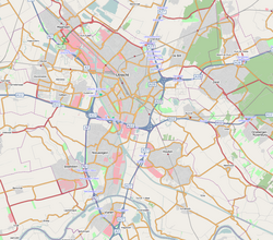
The city of Utrecht and the surrounding cities, villages, and townships form an agglomeration in the middle of The Netherlands. It is located entirely in the province of Utrecht, and is the eastern part of so-called North Wing the larger Randstad urban area.
The agglomeration has a population of about 690,000 people (a rough estimate based on data collected in 2001–2012). The following towns are commonly recognized as part of the agglomeration:
This interpretation of what is to be acknowledged the greater Utrecht area, is the most common one. The physically joint urban area (the innercity-Utrecht area and its surrounding authentic quarters, boroughs and outskirts; the town of Maarssen, which is connected to Utrecht by the Utrecht district of Zuilen and the Lage Weide industrial area; Nieuwegein which has grown attached to the south of the city during the seventies and nineties. To which are attached the smaller suburban towns of IJsselstein and Vianen; the former villages of De Meern and Vleuten, which have been annexed - also formally - by the Utrecht municipality and the western city expansion of Leidsche Rijn; the chained towns of De Bilt and Bilthoven, who are nearly connected to the east side of the city with less than a mile of recreational areas and infrastructure separating both) houses around half a million people. The other 100–200.000 inhabitants making up the entire agglomeration population mostly live in slightly more distant towns such as Zeist, Bunnik, Houten, Breukelen etc. These suburban towns and villages are situated, averagely about four of five miles from the outer districts of Utrecht city. The larger economic, cultural and educational area of which the city of Utrecht is the main centre is equal to the province of Utrecht excluding the small agglomeration of Amersfoort and the town of Veenendaal (which are more self-sufficient and self-orientated). It provides shopping facilities, employment, some large hospitals, cinemas, recreation and other facilities for around 800.000 people. If Woerden, Breukelen and Culemborg are to by included in the greater Utrecht area (seen the vast forensism towards the city) the population would be around 750.000.
In the 1970s and 1980s, large residential areas were built in Maarssen and Zeist, as well as in the new townNieuwegein. In the 1990s, construction of new houses was concentrated in the new town Houten and in the Leidsche Rijn neighbourhood.
Footnotes
↑ Bilthoven is part of the municipality of De Bilt, including this similarly named suburban town.
Related Research Articles
Utrecht, officially the Province of Utrecht, is a province of the Netherlands. It is located in the centre of the country, bordering the Eemmeer in the north-east, the province of Gelderland in the east and south-east, the province of South Holland in the west and south-west and the province of North Holland in the north-west and north. The province of Utrecht has a population of 1,353,596 as of November 2019. With a land area of approximately 1,485 square kilometres (573 sq mi), it is the smallest province in the country. Apart from its eponymous capital, major cities and towns in the province are Amersfoort, Houten, IJsselstein, Nieuwegein, Veenendaal and Zeist. The busiest railway station in the Netherlands, Utrecht Centraal, is located in the province of Utrecht.
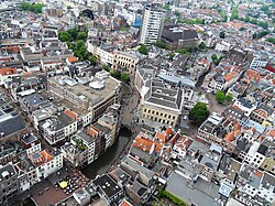
Utrecht is the fourth-largest city and a municipality of the Netherlands, capital and most populous city of the province of Utrecht. It is located in the eastern corner of the Randstad conurbation, in the very centre of mainland Netherlands. It has a population of 361,699 as of December 2021.
Breukelen is a town and former municipality in the Netherlands, in the province of Utrecht. It is situated to the northwest of Utrecht, along the river Vecht and close to the lakes of the Loosdrechtse Plassen, an area of natural and tourist interest. It is located in an area called the Vechtstreek. It is the namesake of the borough of Brooklyn in New York City, United States.
De Bilt is a municipality and town in the province of Utrecht, Netherlands. It had a population of 43,384 in 2021. De Bilt houses the headquarters of the Royal Netherlands Meteorological Institute (KNMI).
Houten is a municipality in the Netherlands, in the province of Utrecht.
IJsselstein is a municipality and city in the Netherlands, in the province of Utrecht. IJsselstein received city rights in 1331. IJsselstein owes its name to the river Hollandse IJssel which flows through the city. It is a major commuting suburb for the Utrecht area, along with the neighbouringing towns Houten and Nieuwegein. It's surrounded by the municipalities of Utrecht, Montfoort, Lopik, Vijfheerenlanden and Nieuwegein.
Maarssen is a town in the middle of the Netherlands, in the province of Utrecht, along the river Vecht and the Amsterdam–Rhine Canal. The west of Maarssen is called Maarssen-Broek whereas the east is called Maarssen-Dorp. Both put together and joined by other small towns around provide the area of Maarssen.
Nieuwegein is a municipality and city in the Dutch province of Utrecht. It is bordered on the north by the city of Utrecht, the provincial capital. It is separated from Vianen to the south by the river Lek and borders on IJsselstein in the southwest and Houten in the east. Nieuwegein has 64,606 inhabitants as of 1 December 2021.
The Lek is a river in the western Netherlands of some 60 km (37 mi) in length. It is the continuation of the Nederrijn after the Kromme Rijn branches off at the town of Wijk bij Duurstede. The main westbound waterway is hereafter called the Lek River. The Nederrijn is, itself, a distributary branch of the river Rhine.
The Randstad is a roughly crescent- or arc-shaped conurbation in the Netherlands, that houses almost half the country's population. With a central-western location, it connects and comprises the Netherlands' four biggest cities, their suburbs, and many towns in between, that all grew and merged into each other. Among other things, it includes the Port of Rotterdam, the Port of Amsterdam, and Amsterdam Airport Schiphol. With a population of approximately 8.4 million people it is one of the largest metropolitan regions in Europe, comparable in population size to the Rhine-Ruhr metropolitan region or the San Francisco Bay Area, and covers an area of approximately 11,372 km2 (4,391 sq mi). The Randstad had a gross regional product of €397 billion in 2017, making it the third most productive region in the European Union, behind the Paris metropolitan area and the Rhine-Ruhr metropolitan region. It encompasses both the Amsterdam metropolitan area and Rotterdam–The Hague metropolitan area. It is part of the larger Blue Banana megalopolis.
The Vecht is a Rhine branch in the Dutch province of Utrecht. It is sometimes called Utrechtse Vecht to avoid confusion with its Overijssel counterpart. The area along the river is called the Vechtstreek.
Bilthoven is a village in the Dutch province of Utrecht. It is a part of the municipality of De Bilt. It has a railway station with connections to Utrecht, Amersfoort and Baarn. It is home to the Netherlands National Institute for Public Health and the Environment, RIVM; and to the Union Mundial pro Interlingua, UMI, which promotes Interlingua internationally.
Leidsche Rijn is a new construction site and neighborhood in Utrecht, the capital of the Dutch province of Utrecht. The area is located west of the Amsterdam–Rhine Canal and its name is derived from the Leidse Rijn canal, which runs through it. At the time of its inception in the 1990s and in the decades that followed, Leidsche Rijn was the largest Vinex location in the Netherlands. Most of this location was on the territory of the former municipality of Vleuten-De Meern, located west of the city of Utrecht. A smaller part of this location, namely the area of Hoge and Lage Weide, was located in the municipality of Utrecht. Vleuten-De Meern was added to the municipality of Utrecht on January 1, 2001. The intended size of the Vinex location was about 30,000 houses for about 90,000 inhabitants. The Utrecht City Council decided to divide it into two districts, namely the Vleuten-De Meern district and the Leidsche Rijn district. Despite this division, the aforementioned neighborhoods are the largest in the municipality of Utrecht in terms of population with approximately 50,000 and 45,000 inhabitants, respectively.
Maartensdijk is a village in the Dutch province of Utrecht. It is a part of the municipality of De Bilt, and lies about 4 km north of Bilthoven.
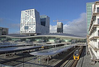
Utrecht Centraal, officially Station Utrecht Centraal, is the transit hub that integrates three bicycle parkings, two bus stations, two tram stops and the central railway station for Utrecht, Netherlands. It is the biggest train station in the Netherlands.
Stichtse Vecht is a municipality of the Netherlands and lies in the northwestern part of the province of Utrecht.
Rijksstraatweg or simply Straatweg was the term for paved roads of interregional significance in the Netherlands in the 19th and early 20th centuries. These roads were built by the national government, and formed the country's first centrally planned highway network. They received route numbers, eventually resulting in a nationwide network of 82 highways. It formed the basis for today's system of nationally controlled roads, the Netherlands' main highway grid.
This is a list of cities, towns and village flags in the Netherlands. The flags are listed per province.
This page is based on this Wikipedia article Text is available under the CC BY-SA 4.0 license; additional terms may apply. Images, videos and audio are available under their respective licenses.