
Buskerud is a county and a current electoral district in Norway, bordering Akershus, Oslo, Oppland, Sogn og Fjordane, Hordaland, Telemark and Vestfold. The region extends from the Oslofjord and Drammensfjorden in the southeast to Hardangervidda mountain range in the northwest. The county administration was in modern times located in Drammen. Buskerud was merged with Akershus and Østfold into the newly created Viken County on 1 January 2020. On the 23 February 2022 Viken County Council voted in a 49 against 38 decision to submit an application to the Norwegian government for a county demerger. Due to this, Buskerud was re-established in 2024.

Nore og Uvdal is a municipality in Buskerud county, Norway. It is part of the traditional region of Numedal. The administrative centre of the municipality is the village of Rødberg.

Hol is a municipality in Buskerud county, Norway.

Rollag is a municipality in Buskerud county, Norway. It is part of the traditional region of Numedal. The administrative centre of the municipality is the village of Rollag, although the most populated area in the municipality is Veggli. Rollag is bordered in the north by Nore og Uvdal, in the east by Sigdal, in the south by Flesberg, and in the west by Tinn in Telemark.
Numedal is a valley and a traditional district in Eastern Norway located within the county of Buskerud. It traditionally includes the municipalities Flesberg, Nore og Uvdal and Rollag. Administratively, it now also includes Kongsberg.
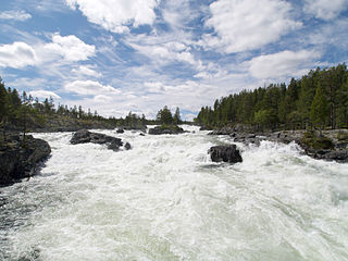
Numedalslågen is a river in Norway. It is considered to be the second longest river in Southern Norway. It is located in the Numedal valley which runs through the counties of Vestfold, Buskerud and Vestland. At 356 kilometres (221 mi) long, it is of the longest rivers in Norway.

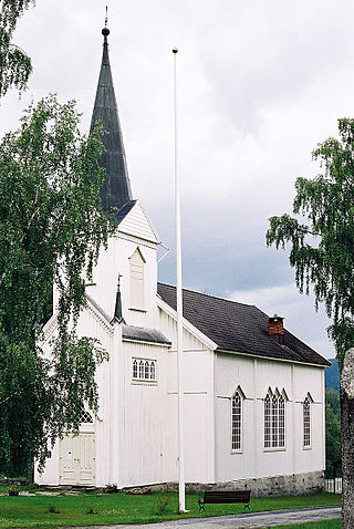
Nore Stave Church is a stave church located at Nore in Nore og Uvdal kommune in Viken county, Norway.
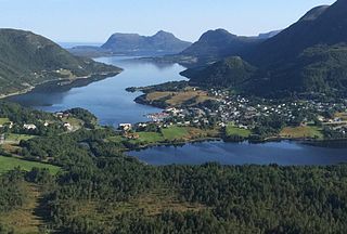
Vatne is a village in Ålesund Municipality in Møre og Romsdal county, Norway. The village of Vatne is located at the southern end of the Vatnefjorden in the eastern part of Haram Municipality. Other neighboring villages in the Vatne area include Eidsvik and Tennfjord to the south and Helle to the north of it.
Veggli is a village in the municipality of Rollag, in the county of Buskerud, Norway.
Nore is a village in the municipality of Nore og Uvdal in the county of Buskerud, Norway. It is located in the traditional region of Numedal.
Barbu is a former municipality in the old Aust-Agder county in Norway. Today, it is part of the is part of the town of Arendal in Agder county. The 15.3-square-kilometre (5.9 sq mi) municipality existed from 1878 until 1902 when it was merged into the town of Arendal. The municipality was located just to the north of what was then the 0.34-square-kilometre (84-acre) town of Arendal. The administrative centre of the small, urban municipality was called Barbu as well. Barbu Church was the church for the municipality.

Borge is a parish and former municipality in Nordland county, Norway. The 200-square-kilometre (77 sq mi) municipality existed from 1838 until 1963. It was located on the northern part of the island of Vestvågøya in what is now Vestvågøy Municipality. The administrative centre of the municipality was the village of Bøstad where Borge Church is located.

Vegusdal is a former municipality in the old Aust-Agder county in Norway. The 325-square-kilometre (125 sq mi) municipality existed from 1877 until its dissolution in 1967. It was located in the northwestern part of the present-day municipality of Birkenes in Agder county. The administrative centre of the municipality was the village of Engesland where Vegusdal Church is located. The Norwegian County Road 405 runs through Vegusdal south to the village of Mosby in Vennesla.
Bjornesfjorden is a lake in the municipality of Nore og Uvdal in Viken county, Norway. It lies at 1,223 meters above sea level. It is drained by the Numedalslågen. Bjornesfjorden is situated in the Hardangervidda plateau and lies within the Hardangervidda National Park.
Øvre Hein is a lake in the municipalities of Nore og Uvdal and Hol in Viken county, Norway. The lake is ;located in the eastern Hardangervidda and lies partly in the Hardangervidda National Park.

Varteig is a village in Sarpsborg and a former municipality in Østfold County, Norway.
Andørja is a former municipality in Troms county in Norway. The 135-square-kilometre (52 sq mi) municipality existed from 1926 until its dissolution in 1964. It was located in the northeastern half of the present-day Ibestad Municipality. It encompassed the entire island of Andørja plus a number of other small islands and skerries surrounding it. The administrative centre was located at Engenes where the Andørja Church was also located.

Evje is a former municipality in the old Aust-Agder county in Norway. The 177-square-kilometre (68 sq mi) municipality existed from 1877 until 1960. It was located in what is now the eastern part of the present-day municipality of Evje og Hornnes in the Setesdal valley of Agder county. The administrative centre was the village of Evje where the Evje Church is located. The lake Høvringsvatnet is located about 10 kilometres (6.2 mi) northeast of the village.
Drevja is a former municipality in Nordland county, Norway. The municipality existed from 1927 until its dissolution in 1962. It was located in the Drevja valley, north of the Vefsnfjorden in the northern part of the present-day Vefsn Municipality. Drevja Church was the main church for the municipality.

Tjøtta is a former municipality in Nordland county, Norway. The 326-square-kilometre (126 sq mi) municipality existed from 1862 until its dissolution in 1965. The municipality was centered around the island of Tjøtta plus the mainland to the east and south as well as over 3000 islands, islets, and skerries to the west. The administrative centre of Tjøtta was the village of Tjøtta, located on the island of Tjøtta, where the Tjøtta Church is located.
