
Iceland is a Nordic island country between the North Atlantic and Arctic Oceans, on the Mid-Atlantic Ridge between North America and Europe. It is culturally and politically linked with Europe and is the region's westernmost and most sparsely populated country. Its capital and largest city is Reykjavík, which is home to about 36% of the country's roughly 380,000 residents. The official language of the country is Icelandic. Iceland is on a rift between tectonic plates, and its geologic activity includes geysers and frequent volcanic eruptions. The interior consists of a volcanic plateau with sand and lava fields, mountains and glaciers, and many glacial rivers flow to the sea through the lowlands. Iceland is warmed by the Gulf Stream and has a temperate climate, despite a latitude just south of the Arctic Circle. Its latitude and marine influence keep summers chilly, and most of its islands have a polar climate.

Reykjavík is the capital of, and largest city in, Iceland. It is located in southwestern Iceland, on the southern shore of Faxaflói Bay. With a latitude of 64°08′ N, the city is the world's northernmost capital of a sovereign state. Reykjavík has a population of around 140,000 as of 2023. The Capital Region has a population of around 248,000.

Iceland is an island country at the confluence of the North Atlantic and Arctic oceans, east of Greenland and immediately south of the Arctic Circle, atop the constructive boundary of the northern Mid-Atlantic Ridge. The island country is the world's 18th largest in area and one most sparsely populated. It is the westernmost European country when not including Greenland and has more land covered by glaciers than continental Europe. Its total size is 103,125 km2 (39,817 sq mi) and possesses an exclusive economic zone of 751,345 km2 (290,096 sq mi).

Erik Thorvaldsson, known as Erik the Red, was a Norse explorer, described in medieval and Icelandic saga sources as having founded the first European settlement in Greenland. Erik most likely earned the epithet "the Red" due to the color of his hair and beard. According to Icelandic sagas, Erik was born in the Jæren district of Rogaland, Norway, as the son of Thorvald Asvaldsson; to which Thorvald would later be banished from Norway, and would sail west to Iceland with Erik and his family. During Erik's life in Iceland, he married Þjódhild Jorundsdottir and would have four children, with one of Erik's sons being the well-known Icelandic explorer Leif Erikson. Around the year of 982, Erik was exiled from Iceland for three years, during which time he explored Greenland, eventually culminating in his founding of the first successful European settlement on the island. Erik would later die there around 1003 CE during a winter epidemic.

Akureyri is a town in northern Iceland, the country's fifth most populous municipality and the largest outside the Capital Region. The municipality includes the town's neighbourhood at the head of Eyjafjörður and two farther islands: Hrísey at the mouth of Eyjafjörður and Grímsey off the coast.

Leif Erikson, also known as Leif the Lucky, was a Norse explorer who is thought to have been the first European to set foot on continental America, approximately half a millennium before Christopher Columbus. According to the sagas of Icelanders, he established a Norse settlement at Vinland, which is usually interpreted as being coastal North America. There is ongoing speculation that the settlement made by Leif and his crew corresponds to the remains of a Norse settlement found in Newfoundland, Canada, called L'Anse aux Meadows, which was occupied approximately 1,000 years ago.

The northern region of Europe has several definitions. A restrictive definition may describe northern Europe as being roughly north of the southern coast of the Baltic Sea, which is about 54°N, or may be based on other geographical factors such as climate and ecology.

The Palearctic or Palaearctic is a biogeographic realm of the Earth, the largest of eight. Confined almost entirely to the Eastern Hemisphere, it stretches across all of Eurasia north of the foothills of the Himalayas, and North Africa.
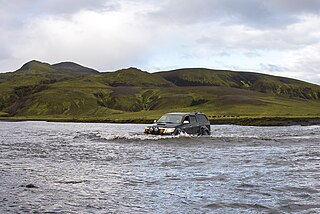
The Highland or The Central Highland is an area that comprises much of the interior land of Iceland. The Highland is situated above 300–400 meters and is mostly uninhabitable. The soil is primarily volcanic ash, and the terrain consists of basalt mountains and lava fields. Snow covers the Highland from October until the beginning of June. A few oasis-like areas, such as Herðubreiðarlindir and Þórsmörk, are also found in the Highland. The area has many notable natural features and hiking trails.

Borgarnes is a town located on a peninsula at the shore of Borgarfjörður in Iceland and is the largest town in the Borgarbyggð municipality with a population of about 3800 residents. It is a main junction in Iceland and the gateway to the Snaefellsnes National Park. Iceland's capital Reykjavík is 69 kilometers from the center of Borgarnes. The second largest bridge in Iceland, the Borgarfjarðarbrú, connects traffic to and from Reykjavík.
Landsvirkjun, the National Power Company of Iceland, is Iceland's largest electricity generator. Landsvirkjun operates 21 power plants in Iceland concentrated on five main areas of operation.

Keflavík Airport, also known as Reykjavík–Keflavík Airport, is the largest airport in Iceland and the country's main hub for international transportation. The airport is located approximately 3 km (1.9 mi) west of the town of Keflavík, Reykjanesbær. and 50 km (30 mi) southwest of Reykjavík. The airport has two runways each measuring approx. 3,050 m (10,010 ft). Most international journeys to or from Iceland pass through this airport.

A state forest or national forest is a forest that is administered or protected by a sovereign or federated state, or territory.
Knattspyrnufélagið Víkingur, commonly referred to as Víkingur Reykjavík and internationally known as Vikingur F.C., is a professional Icelandic sports club based in the Fossvogur neighbourhood of Reykjavík. It is one of the oldest sports clubs in Iceland, founded on 21 April 1908. Originally founded as a football club, it is now a multi-sport club that also operates divisions in handball, tennis, table tennis, karate and skiing. All sports include both male and female teams.

Iceland has a subpolar oceanic climate near the southern coastal area and tundra inland in the highlands. The island lies in the path of the North Atlantic Current, which makes its climate more temperate than would be expected for its latitude just south of the Arctic Circle. This effect is aided by the Irminger Current, which also helps to moderate the island's temperature. The weather in Iceland is notoriously variable.

Rates and causes of deforestation vary from region to region around the world. In 2009, two-thirds of the world's forests were located in just 10 countries: Russia, Brazil, Canada, the United States, China, Australia, the Democratic Republic of the Congo, Indonesia, India, and Peru.
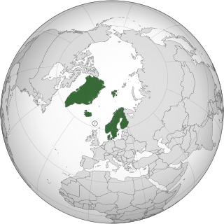
The Nordic countries are a geographical and cultural region in Northern Europe and the North Atlantic. It includes the sovereign states of Denmark, Finland, Iceland, Norway and Sweden; the autonomous territories of the Faroe Islands and Greenland; and the autonomous region of Åland.

Fnjóskadalur is an agricultural valley in northeastern Iceland, approximately 10 km northeast of Akureyri. Fnjóská, a popular salmon angling river and the longest spring-fed river in Iceland, runs through the valley. The river originates on Sprengisandur in the Highlands of Iceland.
Kristín Halldórsdóttir was an Icelandic Women's List politician, journalist and schoolteacher who served two separate terms in the Althing from 1983 to her resignation in 1989 and again between 1995 and 1999. She taught at Digranesskóli in Kópavogur for two winters between 1964 and 1966 and she worked was a journalist at Tíminn and editor of the weekly newspaper Vikuna from 1974 to 1979. Halldórsdóttir was the first vice-president of the Lower House of Althing from 1986 to 1987 and was a substitute member of the Parliamentary Assembly of the Council of Europe for Women's List between 1987 and 1990.


