Tubuai or Tupua'i is the main island of the Tubuai Island group, located at 23°23′00″S149°27′00″W, 640 km (400 mi) south of Tahiti. In addition to Tubuai, the group of islands include Rimatara, Rurutu, Raivavae and the uninhabited Îles Maria. They are part of the Austral Islands in the far southwest of French Polynesia in the south Pacific Ocean. Tubuai island sustains a population of 2,217 people on 45 km² of land. Due to its southerly position, Tubuai has notably cooler weather than Tahiti.

The Tuha'a Pae, or Austral Islands, are the southernmost group of islands in French Polynesia, an overseas collectivity of France in the South Pacific. Geographically, they consist of two separate archipelagos, namely in the northwest the Tupua'i islands consisting of the Îles Maria, Rimatara, Rūrutu, Tupua'i Island proper and Ra'ivāvae, and in the southeast the Bass Islands composed of the main island of Rapa Iti and the small Marotiri. Inhabitants of the islands are known for their pandanus fiber weaving skills. The islands of Maria and Marotiri are not suitable for sustained habitation. Several of the islands have uninhabited islets or rocks off their coastlines. Austral Islands' population is about 6,300 on almost 150 km2 (58 sq mi). The capital of the Austral Islands administrative subdivision is Tupua'i.
The Robert Wan Pearl Museum is the world's only museum dedicated to pearls. It is in Papeete, Tahiti, the capital of French Polynesia.
The Pape'ete Tahiti Temple is the 27th constructed and 25th operating temple of The Church of Jesus Christ of Latter-day Saints. Located in the city of Pape'ete on the island of Tahiti in French Polynesia, it was built with a modern single-spire design.

Uturoa is a commune of French Polynesia, which is an overseas territory of France in the Pacific Ocean. Uturoa is located on Raiatea, the largest island of the Îles Sous le Vent, located in the western region of the Society Islands. Uturoa is the administrative center of the administrative subdivision of the Leeward Islands and is the main port of Raiatea. According to the 2017 census, Uturoa had a population of 3,736. Uturoa is about 120 miles northwest of Papeete, which is the capital of French Polynesia.
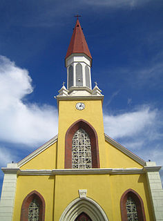
Notre Dame Cathedral is a late 19th-century church that serves as the cathedral of the Roman Catholic Archdiocese of Papeete. It is located close to the waterfront esplanade of the capital city on the rue du Général de Gaulle.

The Paul Gauguin Museum is a Japanese-styled art museum dedicated to the life and works of Paul Gauguin in Tahiti, French Polynesia. The museum has been "closed for renovations" since 2013.

Marché Papeete or Papeete Market is an extensive market place in Papeete, the capital of Tahiti.
Papeari is a village on the south coast of Tahiti. It is located in Tahiti-nui district, around 32 miles from Papeete.

Kamaka is an island in the Gambier Islands of French Polynesia, 11.7 km south of Mangareva within the same lagoon. Kamaka is about one kilometre in length, 700 metres wide, and has an area of 0.5 square kilometres. The highest point is 166 metres above sea level.

Makaroa is an island in the Gambier Islands of French Polynesia, 8.5 km south of Mangareva within the same lagoon. Makaroa is about 1.3 km (1 mi) in length and has a small rocky islet off its NW point.
The Hitia'a Hydroelectric Power Station, also called Faatautia Hydroelectric Power Station, is located near the commune of Hitia'a on the island Tahiti in the overseas country of France, French Polynesia. It has an installed capacity of 7.54 MW and was constructed between 1983 and 1988. The hydroelectric power station is owned by Electricite de Tahiti SA.
The Papenoo Hydroelectric Power Station is located near the commune of Papenoo on the island Tahiti in the overseas country of France, French Polynesia. It has an installed capacity of 28 MW and was constructed between 1989 and 1994. The hydroelectric power station is owned by Electricite de Tahiti SA. It is the largest hydroelectric power station in Tahiti.
Papuri is an island of the Gambier Islands of French Polynesia.

Point Venus is a peninsula on the north coast of Tahiti, the largest island in the Windward group of French Polynesia. It is in the commune of Mahina, approximately 8 km east of the capital Pape'ete. It lies at the northeast end of Matavai Bay.
Hitikau is a volcanic mountain of Ua Huka, in the Marquesas Islands of Polynesia. It has an elevation of 884 metres (2,900 ft), the highest point of the island, and lies to the northeast of the village of Hane.

St. Michael's Cathedral, also known as the Rikitea Cathedral, is a parish of the Catholic Church located on Mangareva Island in the Gambier Islands of French Polynesia.

Hane is the largest settlement on the island of Ua Huka, in the Marquesas Islands of French Polynesia. Hane, a notable archaeological site, has a smaller population than the capital of Vaipae'e.
Internal Autonomy Day is an official holiday in French Polynesia, an overseas collectivity of France. It is celebrated annually on 29 June, to honor Tahitian and French Polynesian self-rule. The day also marked the annexation of the Kingdom of Tahiti and the turnover of native sovereignty by King Pōmare V to France.