
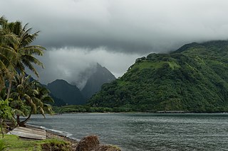
Tahiti is the largest island of the Windward group of the Society Islands in French Polynesia. It is located in the central part of the Pacific Ocean and the nearest major landmass is Australia. Divided into two parts, Tahiti Nui and Tahiti Iti, the island was formed from volcanic activity; it is high and mountainous with surrounding coral reefs. Its population was 189,517 in 2017, making it by far the most populous island in French Polynesia and accounting for 68.7% of its total population; the 2022 Census recorded a population of 191,779.

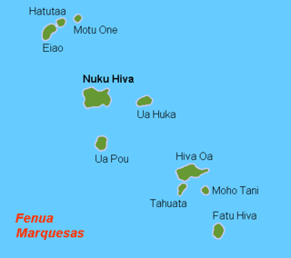
The Marquesas Islands are a group of volcanic islands in French Polynesia, an overseas collectivity of France in the southern Pacific Ocean. Their highest point is the peak of Mount Oave on Ua Pou island, at 1,230 m (4,035 ft) above sea level.

Bora Bora is an island group in the Leeward Islands in the South Pacific. The Leeward Islands comprise the western part of the Society Islands of French Polynesia, which is an overseas collectivity of the French Republic in the Pacific Ocean. Bora Bora has a total land area of 30.55 km2 (12 sq mi). The main island, located about 230 kilometres northwest of Papeete, is surrounded by a lagoon and a barrier reef. In the center of the island are the remnants of an extinct volcano, rising to two peaks, Mount Pahia and Mount Otemanu; the highest point is at 727 m (2,385 ft). Bora Bora is part of the Commune of Bora-Bora, which also includes the atoll of Tūpai. The main languages spoken in Bora Bora are Tahitian and French. However, due to the high tourist population, many natives of Bora Bora have learned to speak English.

Moʻorea, also spelled Moorea, is a volcanic island in French Polynesia. It is one of the Windward Islands, a group that is part of the Society Islands, 17 kilometres (11 mi) northwest of Tahiti. The name comes from the Tahitian word Moʻoreʻa, meaning "yellow lizard": Moʻo = lizard ; Reʻa = yellow. An older name for the island is ʻAimeho, sometimes spelled ʻAimeo or ʻEimeo. Early Western colonists and voyagers also referred to Moʻorea as York Island or Santo Domingo.

The Austral Islands are the southernmost group of islands in French Polynesia, an overseas country of the French Republic in the South Pacific. Geographically, they consist of two separate archipelagos, namely in the northwest the Tupua'i islands consisting of the Îles Maria, Rimatara, Rūrutu, Tupua'i Island proper and Ra'ivāvae, and in the southeast the Bass Islands composed of the main island of Rapa Iti and the small Marotiri. Inhabitants of the islands are known for their pandanus fiber weaving skills. The islands of Maria and Marotiri are not suitable for sustained habitation. Several of the islands have uninhabited islets or rocks off their coastlines. Austral Islands' population is 6,965 on almost 150 km2 (58 sq mi). The capital of the Austral Islands administrative subdivision is Tupua'i.

With its 320 square kilometres, Hiva Oa is the second largest island in the Marquesas Islands, in French Polynesia, an overseas territory of France in the Pacific Ocean. Located at 9 45' south latitude and 139 W longitude, it is the largest island of the southern Marquesas group. Around 2,200 people reside on the island. A volcano, Temetiu, is Hiva Oa's highest point with 1,200 metres.

Motu One is the name of a small sandbank with no vegetation, located on the western edge of a coral reef; the only atoll in the Marquesas Islands.
Hatutu is a small island approximately 3 km (2 mi.) northeast of Eiao in the northern Marquesas Islands. It is approximately 3 km from Eiao by a channel 50 meters deep. It was also known by the names Hancock, Chanal, Langdon, and Nexsen
Eiao is the largest of the extreme northwestern Marquesas Islands. The island is uninhabited, but is administratively part of the commune (municipality) of Nuku-Hiva, itself in the administrative subdivision of the Marquesas Islands.
The Motu One Reserve is a nature reserve encompassing the whole of the island and reef system of Motu One in the northern Marquesas Islands. The reserve was declared in 1992 in combination with several other reserves were declared as a part of the Marquesan Nature Reserves. This includes the Hatutu Nature Reserve, the Motane Nature Reserve, and the Eiao Island Nature Reserve.
The Marquesan Nature Reserves are a network of small nature reserves in the Marquesas Islands. The reserves were declared by the government of French Polynesia in 1992, as a first step toward preserving the native flora and fauna of some of the smaller islands of the group.

The Eiao Nature Reserve is a nature reserve encompassing the whole of the island of Eiao in the northern Marquesas Islands, as well as several surrounding rocks.

Ua Huka is one of the Marquesas Islands, in French Polynesia, an overseas territory of France in the Pacific Ocean. It is situated in the northern group of the archipelago, approximately 25 mi (40 km) to the east of Nuku Hiva, at 8°54′S139°33′W.

Mahina is a commune in the north of Tahiti in French Polynesia, an overseas territory of France in the Pacific Ocean. Mahina is located on the island of Tahiti, in the administrative subdivision of the Windward Islands, themselves part of the Society Islands. Mahina is the 5th most populous commune in French Polynesia with a population of 14,623, in an area of 52 km2. Mount Orohena is a nearby mountain.
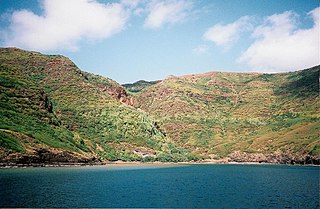
Tautira is a Polynesian beach village, valley, and point on the south-east coast of the island of Tahiti in the Pacific. It is part of the commune Taiʻarapu-Est. With a population of 2,527, it is located 49 kilometres southeast of the Tahitian capital of Papeete on the coast of Tautira Bay, at the end of what is the largest valley of the Taiarapu Peninsula. Domingo de Bonechea visited the area in 1772 and attempted to spread Christianity here; James Cook landed at Tautira Bay during his voyage. Robert Louis Stevenson referred to the village as “The Garden of the World”, staying here to recover from illness in 1886. The village contains a Catholic church.

The Marquesas Islands are the island group farthest from any continent in the world, lying between 400 and 600 miles south of the equator and approximately 740 miles (1,200 km) northeast of Tahiti. A pair of volcanic archipelagoes, they fall naturally into two geographical divisions, The northwestern group consists of Eïao, Hatutu (Hatutaa), Motu One, and the islands centered on the large island of Nuku Hiva: Motu Iti, Ua Pou, Motu Oa and Ua Huka. The southeastern group consists of Fatu Uku, Tahuata, Moho Tani (Motane), Terihi, Fatu Hiva and Motu Nao, clustered around the main island of Hiva Oa which is the largest and most populous island of the southeastern group.

This page list topics related to French Polynesia.
Nuku Hiva is the largest of the Marquesas Islands in French Polynesia, an overseas country of France in the Pacific Ocean. It was formerly also known as Île Marchand and Madison Island.

Tautavel Man refers to the archaic humans which—from approximately 550,000 to 400,000 years ago—inhabited the Caune de l’Arago, a limestone cave in Tautavel, France. They are generally grouped as part of a long and highly variable lineage of transitional morphs which inhabited the Middle Pleistocene of Europe, and would eventually evolve into the Neanderthals. They have been variably assigned to either H. (s.?) heidelbergensis, or as a European subspecies of H. erectus as H. e. tautavelensis. The skull is reconstructed based on the specimens Arago 21 and 47, and it is, to a degree, more characteristic of what might be considered a typical H. erectus morphology than a typical H. heidelbergensis morphology. The brain capacity is 1,166 cc. They seem to have had an overall robust skeleton. Average height may have been 166 cm.
Michel Charleux was a French archaeologist who did much of his work in French Polynesia and did important work on Tapa cloth.


