Related Research Articles

Highland Village is a neighborhood in Houston, Texas, United States.

Plantation Key is an island in Monroe County, Florida, United States. It is located in the upper Florida Keys on U.S. 1, between Key Largo and Windley Key.
Plantation Key, Florida is a former census-designated place on Plantation Key in the Florida Keys, in Monroe County, Florida, United States. It is located just South of the Tavernier bridge and North of the Snake Creek bridge and was reported to have a population of 4,405 in 1990. It became part of the Village of Islamorada when the latter incorporated in 1997.

Conch Key is an island and unincorporated community in Monroe County, Florida, United States, located in the middle Florida Keys. U.S. 1 crosses the key at approximately mile markers 62–63, between Long and Duck Keys. It is part of the census-designated place of Duck Key.

KPAT is a commercial radio station that is licensed to Orcutt, California, United States and serves the Santa Maria—Lompoc area. The station is owned by American General Media and broadcasts a rhythmic contemporary format.

KFIN is a commercial radio station located in Jonesboro, Arkansas, broadcasting on 107.9 FM. KFIN airs a country music format. KFIN is a 98,000 watt station, reaching listeners in all of Northeast Arkansas, as well as Southeast Missouri, Western Tennessee, and Western Mississippi.
WCVM is a radio station licensed to Bronson, Michigan. The station rebroadcasts WBCL, the contemporary Christian music station owned and operated by Taylor University in Fort Wayne, Indiana. The station's transmitter is located near the corner of County Roads E700N and N950E, southwest of Greenfield Mills, Indiana.

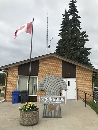
Springside is a town in Saskatchewan, Canada, in the Rural Municipality of Orkney No. 244. It is about 24 kilometres (15 mi) northwest of the city of Yorkton along the Yellowhead Highway.
Gharua is a village located within the Sheola Union, Beanibazar Upazila, Sylhet District, Bangladesh. Its population is less than 500 people. Gharua has a government primary school.

Yunnan Agricultural University is in Kunming, Yunnan, China.
Jewfish is an unincorporated community in Monroe County, Florida, United States. It is located in the upper Florida Keys on Key Largo off U.S. Route 1. It is just west of the census-designated place (CDP) of North Key Largo.
Smith's Harbour is a local service district and designated place in the Canadian province of Newfoundland and Labrador.
Valhalla Vineyards is a vineyard and winery located in Roanoke County, Virginia, founded by James and Debra Vascik in 1994.
The Weston Museum is located within the Van Houten Library at the New Jersey Institute of Technology in the University Heights section of Newark, New Jersey. The small museum contains items developed and manufactured by Edward Weston, as well as instruments and devices from his laboratory. A contemporary of Thomas Edison, Weston was a scientist, an inventor, and a founding member of the board of trustees of the university and the Weston Electric Company. Dr. Weston's rare book collection is also maintained available to scholars and others interested in the history of science and technology.

Clam Bayou is a 170-acre estuary between Gulfport, Florida, St. Petersburg, Florida, and Boca Ciega Bay. The neighborhood around the estuary is also known as Clam Bayou. The area is popular with kayakers. It is also home to the 10-acre Clam Bayou Nature Park that includes a canoe and kayak launch point.
Zibogo is a community in Tamale Metropolitan District in the Northern Region of Ghana.
Galena City School District is a school district in Galena, Alaska.

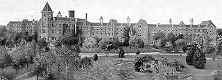
Terrell State Hospital is a public psychiatric hospital located in Terrell, Texas, United States. Opened in 1885, it was originally known as the North Texas Lunatic Asylum. The original hospital building was built according to the Kirkbride Plan.

Glantwymyn is a community in the northwest (Montgomeryshire) of Powys, Wales.
The Southeast Water Pollution Control Plant, also called the Southeast Treatment Plant, is a wastewater treatment plant operated by the San Francisco Public Utilities Commission, in San Francisco, California, United States. It is located in the southeastern portion of the city in the Bayview-Hunters Point neighborhood.
References
24°44′31″N80°58′41″W / 24.742°N 80.978°W