Valles Caldera is a 13.7-mile (22.0 km) wide volcanic caldera in the Jemez Mountains of northern New Mexico. Hot springs, streams, fumaroles, natural gas seeps and volcanic domes dot the caldera floor landscape. The highest point in the caldera is Redondo Peak, an 11,253-foot (3,430 m) resurgent lava dome located entirely within the caldera. Also within the caldera are several grass valleys, or valles, the largest of which is Valle Grande, the only one accessible by a paved road. In 1975, Valles Caldera was designated as a National Natural Landmark by the National Park Service with much of the caldera being within the Valles Caldera National Preserve, a unit of the National Park System.

The Lower Rio Grande Valley, commonly known as the Rio Grande Valley or locally as the Valley or RGV, is a region spanning the border of Texas and Mexico located in a floodplain of the Rio Grande near its mouth. The region includes the southernmost tip of South Texas and a portion of northern Tamaulipas, Mexico. It consists of the Brownsville, Harlingen, Weslaco, Pharr, McAllen, Edinburg, Mission, San Juan, and Rio Grande City metropolitan areas in the United States and the Matamoros, Río Bravo, and Reynosa metropolitan areas in Mexico. The area is generally bilingual in English and Spanish, with a fair amount of Spanglish due to the region's diverse history and transborder agglomerations. It is home to some of the poorest cities in the nation, as well as many unincorporated, persistent poverty communities called colonias. A large seasonal influx occurs of "winter Texans" — people who come down from the north for the winter and then return north before summer arrives.

The Ossola is an area of Italy situated to the north of Lago Maggiore. It lies within the Province of Verbano-Cusio-Ossola. Its principal river is the Toce, and its most important town Domodossola.

The province of Milan was a province in the Lombardy region of Italy. Its capital was the city of Milan. The area of the former province is highly urbanized, with more than 2,000 inhabitants/km2, the third highest population density among Italian provinces, just below the densities of the provinces of Naples and of Monza e Brianza, the latter of which was created in 2004 from the north-eastern part of the province of Milan. On 1 January 2015 the province was replaced by the Metropolitan City of Milan.
The Jemez Mountains are a group of mountains in Rio Arriba, Sandoval, and Los Alamos counties, New Mexico, United States.
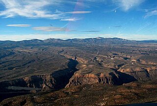
The Pajarito Plateau is a volcanic plateau in north central New Mexico, United States. The plateau, part of the Jemez Mountains, is bounded on the west by the Sierra de los Valles, the range forming the east rim of the Valles Caldera, and on the east by the Puye escarpment, which rises about 300 to 400 feet above the Rio Grande valley about a mile (1.6 km) west of the river. The Rio Grande passes through White Rock Canyon to the southeast, and the Caja del Rio across the river is sometimes regarded as part of the plateau. The plateau is occupied by several notable entities, including Bandelier National Monument, the town of Los Alamos and its remote suburb White Rock, and Los Alamos National Laboratory. Elevations range from about 5,600 feet at the river to about 7,800 feet where the plateau merges into the mountain range.

The Río Grande de Santiago, or Santiago River, is a river in western Mexico. It flows westwards from Lake Chapala via Ocotlán through the states of Jalisco and Nayarit to empty into the Pacific Ocean. It is one of the longest rivers in Mexico, measuring up 433 km (269 mi) long.
Rio Grande City Grulla Independent School District (RGCGISD), formerly Rio Grande City Consolidated Independent School District, is a public school district based in Rio Grande City, Texas (USA).

La Lisa is one of the 15 municipalities or boroughs in the city of Havana, Cuba.

The Central Valleys of Oaxaca, also simply known as the Oaxaca Valley, is a geographic region located within the modern-day state of Oaxaca in southern Mexico. In an administrative context, it has been defined as comprising the districts of Etla, Centro, Zaachila, Zimatlán, Ocotlán, Tlacolula and Ejutla. The valley, which is located within the Sierra Madre Mountains, is shaped like a distorted and almost upside-down “Y,” with each of its arms bearing specific names: the northwestern Etla arm, the central southern Valle Grande, and the Tlacolula arm to the east. The Oaxaca Valley was home to the Zapotec civilization, one of the earliest complex societies in Mesoamerica, and the later Mixtec culture. A number of important and well-known archaeological sites are found in the Oaxaca Valley, including Monte Albán, Mitla, San José Mogote and Yagul. Today, the capital of the state, the city of Oaxaca, is located in the central portion of the valley.
The New Mexico Charity Classic was a golf tournament on the Nike Tour. It ran from 1993 to 1994. In 1993, it was played at Valle Grande Golf Course in Santa Ana Pueblo, New Mexico. In 1994, it was played at the University of New Mexico Championship Course in Albuquerque, New Mexico.
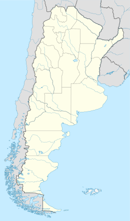
Valle Grande or Vallegrande may refer to:
Tlacolula District is located in the east of the Valles Centrales Region of the State of Oaxaca, Mexico.

The Jemez River is a tributary of the Rio Grande in eastern Sandoval County, New Mexico, United States.

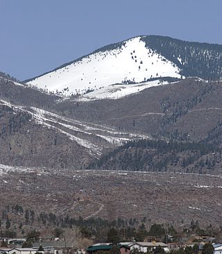
Cerro Grande is a 10,207-foot (3,111 m) summit on the rim of the Valles Caldera not far north of New Mexico State Road 4, the main highway through Los Alamos County. Like many mountains in the Jemez, Cerro Grande was mainly covered with coniferous forest, composed largely of ponderosa pine and aspen trees, with a characteristic rincon (meadow) on its slopes on and south of the summit.

The Lanzo Valleys is a group of three valleys in the north-west of Piedmont in the Metropolitan City of Turin, Italy. They are located in the Graian Alps of Piedmont, between the Valle dell'Orco to the north and the Val di Susa to the south. Crossed by various streams which in each valley is called Stura and which flow into the river Stura di Lanzo, the valleys take their name from the town of Lanzo, located on an ancient glacial moraine at the end of the valleys.
The Valle de Oro National Wildlife Refuge is a protected area in New Mexico managed by the United States Fish and Wildlife Service as part of the National Wildlife Refuge System. It is located 7 miles (11 km) south of Albuquerque, New Mexico. This unit abuts the Rio Grande Valley State Park, which is adjacent to the Rio Grande.
Valle Vista is a census-designated place (CDP) in Starr County, Texas, United States. It is a new CDP formed from part of the old La Victoria CDP prior to the 2010 census with a population of 469.
Valle Hermoso is a census-designated place (CDP) in Starr County, Texas, United States. Although a new CDP for the 2010 census, the population was listed as zero.