
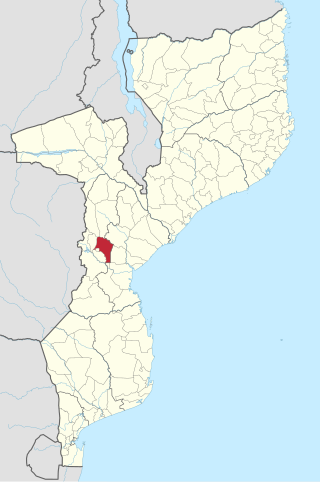
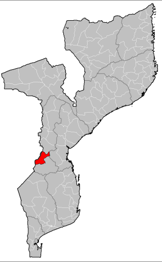
Vanduzi District is a district in Manica Province of Mozambique.
Vanduzi District is a district in Manica Province of Mozambique.
The district has an area of 2,825 km2. It is bounded on the west by Manica District, on the northwest by Barue District, on the northeast by Macossa District and Sofala Province, on the east by Gondola District, on the southeast by Chimoio District, and on the south by Macate and Sussundenga districts. [1]
The district has a population of 140,476, and a population density of 50 persons per km2. [2]

The administrative headquarters for the district is in the town of Vanduzi.
The district is divided into two administrative postos, Matsinho (two localities, Chiremera [3] and Matsinho) and Vanduzi (three localities, Chigodore, Pungué Sul, and Vanduzi).
Vanduzi District was created by the Mozambican legislature in 2013. [4] Prior to that, Vanduzi posto was part of Manica District, and Matsinho posto was part of Gondola District.

Manica is a province of Mozambique. It has an area of 62,272 km² and a population of 1,945,994. The province is surrounded by Zimbabwe in the west, Tete Province in the northwest, Sofala Province in the east, Save River in the south, and Zambezi river in the northeast. Chimoio is the capital of the province. The highest mountain in Mozambique, Mount Binga, lies in this province near the border with Zimbabwe. The Manica province is divided into nine districts and 34 administrative regions.

Gorongosa District is a district of Sofala Province in Mozambique. The principal town is Gorongosa. The district is located in the northwest of the province, and borders with Maringué District in the north, Cheringoma District in the east, Muanza District in the southeast, Nhamatanda District in the south, and with Macossa and Gondola Districts of Manica Province in the west. The area of the district is 6,722 square kilometres (2,595 sq mi). It has a population of 116,912 as of 2007.

Guijá District is a district of Gaza Province in south-western Mozambique. The administrative center of the district is Caniçado. The district is located at the south of the province, and borders with Chigubo District in the north, Chibuto District in the east, Chókwè District in the south, and with Mabalane District in the west. The area of the district is 4,207 square kilometres (1,624 sq mi). It has a population of 75,303 as of 2007.

Báruè District is a district of Manica Province in western Mozambique. Its principal town is Catandica. The district is located in the west of the province, and borders with Guro District in the north, Macossa District in the east, Gondola District in the southeast, Manica District in the south, and with Zimbabwe in the west. The area of the district is 5,743 square kilometres (2,217 sq mi). It has a population of 137,582 as of 2007.
Gondola District is a district of Manica Province in western Mozambique. The principal town is Gondola. The area of the district is 5,739 square kilometres (2,216 sq mi). It has a population of 262,412 as of 2007.

Guro District is a district of Manica Province in western Mozambique. The principal town is Guro. The district is located in the north of the province, and borders with Changara District of Tete Province in the north, Tambara District in the east, Macossa District in the south, and Báruè District in the southwest. The area of the district is 6,928 square kilometres (2,675 sq mi). It had a population of 68,526 as of 2007 and 83,972 as of 2013

Machaze District is a district of Manica Province in western Mozambique. The principal town is Machaze. The district is located in the south of the province, and borders with Mossurize District in the north, Chibabava District of Sofala Province in the northeast, Machanga District of Sofala Province in the east, Mabote District of Inhambane Province in the south, Massangena District of Gaza Province in the southwest, and with Zimbabwe in the west. The area of the district is 13,189 square kilometres (5,092 sq mi). It has a population of 104,608 as of 2007.

Macossa District is a district of Manica Province in western Mozambique. The principal town is Macossa. The district is located in the east of the province, and borders with Tambara District in the north, Maringué District of Sofala Province in the northeast, Gorongosa District of Sofala Province in the east, Gondola District in the south, Báruè District in the west, and with Guro District in the northwest. The area of the district is 9,554 square kilometres (3,689 sq mi). It has a population of 27,245 as of 2007.

Manica District is a district of Manica Province in western Mozambique. The principal town is Manica. The district is located in the west of the province, and borders with Báruè District in the north, Vanduzi District in the east, Sussundenga District in the south, and with Zimbabwe in the west. The area of the district is 4,594 square kilometres (1,774 sq mi). It has a population of 213,206 as of 2007.
Mossurize District is a district of Manica Province in western Mozambique. The principal town is Espungabera. The district is located in the south of the province, and borders with Sussundenga District in the north, Chibabava District of Sofala Province in the east, Machaze District in the south, and with Zimbabwe in the west. The area of the district is 5,038 square kilometres (1,945 sq mi). It has a population of 195,182 as of 2007.

Sussundenga District is a district of Manica Province in western Mozambique. The principal town is Sussundenga. The district is located in the center of the province, and borders with Manica District in the north, Gondola District in the northeast, Buzi District of Sofala Province in the east, Chibabava District of Sofala Province in the southeast, Mossurize District in the south, and with Zimbabwe in the west. The area of the district is 7,057 square kilometres (2,725 sq mi). It has a population of 129,851 as of 2007.

Tambara District is a district of Manica Province in western Mozambique. The principal town is Nhacolo. The district is located in the north of the province, and borders with Tete Province in the north, Chemba District of Sofala Province in the east, Maringué District of Sofala Province in the southeast, Macossa District in the south, and with Guro District in the west. The area of the district is 3,892 square kilometres (1,503 sq mi). It has a population of 41,339 as of 2007.

Buzi District is a district of Sofala Province in Mozambique. The principal town is Búzi. The district is located in the southeast of the province, and borders with Nhamatanda District in the north, Dondo District in the northeast, Machanga District in the south, Chibabava District in the southwest, Sussundenga District of Manica Province in the west, and with Gondola District of Manica Province in the northwest. The area of the district is 7,329 square kilometres (2,830 sq mi). It has a population of 159,614 as of 2007.

Chemba District is a district of Sofala Province in Mozambique. The principal town is Chemba. The district is located in the north of the province, and borders with Tete Province in the northeast, Caia District in the southeast, Maringué District in the southwest, and with Tambara District of Manica Province in the northwest. The area of the district is 3,998 square kilometres (1,544 sq mi). It has a population of 65,107 as of 2007.
Chibabava District is a district of Sofala Province in Mozambique. The principal town is Chibabava. The district is located in the south of the province, and borders with Buzi District in the north, Machanga District in the southeast, with Machaze and Mossurize Districts of Manica Province in the west, and with Sussundenga District of Manica Province in the northwest. The area of the district is 6,977 square kilometres (2,694 sq mi). It has a population of 101,667 as of 2007.

Machanga District is a district of Sofala Province in Mozambique. The principal town is Machanga. The district is located in the south of the province, and borders with Buzi District in the north, Mabote and Govuro Districts of Inhambane Province in the south, Machaze District of Manica Province in the west, and with Chibabava District in the northwest. In the east, the district is limited by the Indian Ocean. The area of the district is 5,940 square kilometres (2,290 sq mi). It has a population of 51,855 as of 2007.
Maringué District is a district of Sofala Province in Mozambique. The principal town is Maringué. The district is located in the north of the province, and borders with Chemba District in the north, Caia District in the east, Cheringoma District in the southeast, Gorongosa District in the south, with Macossa District of Manica Province in the west, and with Tambara District of Manica Province in the northwest. The area of the district is 6,176 square kilometres (2,385 sq mi). It has a population of 75,089 as of 2007.

Nhamatanda District is a district of Sofala Province in Mozambique. The principal town is Nhamatanda. The district is located in the center of the province, and borders with Gorongosa District in the north, Muanza District in the northeast, Dondo District in the east, Buzi District in the south, and with Gondola District of Manica Province in the west. The area of the district is 3,987 square kilometres (1,539 sq mi). It has a population of 210,757 as of 2007.

Changara District is a district of Tete Province in western Mozambique. The principal town is Luenha. The district is located in the south of the province, and borders with Chiuta District in the north, Moatize District in the east, Guro District of Manica Province in the south, Zimbabwe in the southwest, and with Cahora-Bassa District in the west. The area of the district is 8,660 square kilometres (3,340 sq mi). It has a population of 156,738 as of 2007.

Macate District is a district in Manica Province of Mozambique.