
Sogn og Fjordane was, up to 1 January 2020, a county in western Norway, when it was merged to become part of Vestland county. Bordering previous counties Møre og Romsdal, Oppland, Buskerud, and Hordaland, the county administration was in the village of Hermansverk in Leikanger municipality. The largest town in the county was Førde.

Høyanger is a municipality in Vestland county, Norway. It is located in the traditional district of Sogn. The administrative center is the village of Høyanger. Other villages in Høyanger municipality include Austreim, Bjordal, Kyrkjebø, Lavik, Ortnevik, and Vadheim.

Vik is a municipality in Vestland county, Norway. It is located on the southern shore of the Sognefjorden in the traditional district of Sogn. The administrative center of Vik is the village of Vikøyri. Other villages in the municipality include Feios, Fresvik, Nese, and Vangsnes.

Balestrand is a former municipality in Sogn og Fjordane county, Norway. It was located on the northern shore of the Sognefjorden in the traditional district of Sogn. The administrative center was the village of Balestrand. Other villages in the municipality included Ese, Kvamme, Låne, Sæle, Tjugum, and Vetlefjorden.

Leikanger is a former municipality in Sogn og Fjordane county, Norway. It was located on the northern shore of the Sognefjorden in the traditional district of Sogn. The administrative center was the village of Hermansverk, which also was the administrative center of the old Sogn og Fjordane county.

Sogndal is a municipality in Vestland county, Norway. It is located on the northern shore of the Sognefjorden in the traditional district of Sogn. The village of Hermansverk is the administrative center of Sogndal municipality. Other villages include Kaupanger, Kjørnes, Fimreite, Nornes, and Fjærland. Sogndal Airport, Haukåsen is located 10 kilometres (6.2 mi) southwest of Kaupanger.

The Sognefjord or Sognefjorden, nicknamed the King of the Fjords, is the largest and deepest fjord in Norway. Located in Vestland county in Western Norway, it stretches 205 kilometres (127 mi) inland from the ocean to the small village of Skjolden in the municipality of Luster.

Frithiof's Saga is a legendary saga from Iceland which in its present form is from ca. 1300. It is a continuation from The Saga of Thorstein Víkingsson. It takes place principally in Norway during the 8th century.

European route E39 is the designation of a 1,330 kilometres (830 mi) north–south road in Norway and Denmark from Klett, just south of Trondheim, to Aalborg via Bergen, Stavanger and Kristiansand. In total, there are nine ferries, more than any other single road in Europe.

Fresvik is a village in the municipality of Vik in Vestland county, Norway. It is located on the southern shore of the Sognefjorden, just west of where the Aurlandsfjorden joins the Sognefjorden. Fresvik sits about 13 kilometres (8.1 mi) south of Leikanger-Hermansverk, about 20 kilometres (12 mi) east of the municipal center of Vikøyri, and about 15 kilometres (9.3 mi) southeast of the village of Feios. The population (2001) of Fresvik is approximately 275.

Esefjorden is a fjord arm on the north side of the Sognefjord in the municipality of Sogndal in Vestland county, Norway. The fjord is about 4 kilometres (2.5 mi) long and its mouth is just west of the mouth of the larger Fjærlandsfjord. The village of Balestrand is located on the south side of the fjord, at the mouth. The village of Tjugum lies at the north side of the mouth of the fjord. At Dragsviki, just east of Tjugum, there are regular ferry connections to Hella in Sogndal Municipality and to Vangsnes in Vik Municipality. Tjugum Church is located on the shore of the Esefjorden, just east of Dragsviki. The Norwegian County Road 55 follows the shoreline of the fjord on both sides.
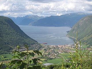
Vikøyri is the administrative center of the municipality of Vik in Vestland county, Norway. The village is located at the mouth of the Vikja river on the south shore of the Sognefjorden, roughly near the midpoint of Norway's longest fjord. The village lies along Norwegian National Road 13 which leads north to the ferry to Balestrand and south to the village of Vossevangen. The 1.37-square-kilometre (340-acre) village has a population (2019) of 1,245 and a population density of 909 inhabitants per square kilometre (2,350/sq mi).

Sogn is a traditional district in Western Norway (Vestlandet). It is located in the county of Vestland, surrounding the Sognefjord, the largest/longest fjord in Norway. The district of Sogn consists of the municipalities of Aurland, Balestrand, Hyllestad, Høyanger, Gulen, Leikanger, Luster, Lærdal, Sogndal, Solund, Vik, and Årdal. The district covers 10,675 square kilometres (4,122 sq mi) and contains about 35% of the county's population. The largest urban area in Sogn is the village of Sogndalsfjøra, with 3,455 residents. The second largest urban area is the village Øvre Årdal, with 3,397 people.
Hermansverk is the administrative centre of Sogndal Municipality in Vestland county, Norway. The village serves as the seat of the County Governor of Vestland county.

Balestrand is a village in Sogndal Municipality in Vestland county, Norway. The village is located on the northern shore of the Sognefjorden, at the mouth of the small Esefjorden. It sits about 20 kilometres (12 mi) west of the village area of Leikanger-Hermansverk and about 7 kilometres (4.3 mi) northwest of the village of Vangsnes. The small village of Tjugum lies less than 700 metres (2,300 ft) north of Balestrand, across the Esefjorden. The local Tjugum Church is located there, serving the people of the village of Balestrand.

Feios is a village in Vik Municipality in Vestland county, Norway. The village is located on the southern shore of the Sognefjorden, about 8 kilometres (5.0 mi) southeast of the village of Vangsnes and about 17 kilometres (11 mi) northwest of the village of Fresvik. The village lies in a small, narrow valley, surrounded by large mountains, with the river Feioselvi running through the center of the valley. Feios Church is located in the village.

Kvamsøy is a small island in Sogndal Municipality in Vestland county, Norway. The 80-hectare (200-acre) island lies in the Sognefjorden, just off the coast of the village of Kvamme. The island lies about 150 metres (490 ft) off the coast. The village of Vikøyri lies about 7 kilometres (4.3 mi) to the southeast and the village of Balestrand lies about 10 kilometres (6.2 mi) to the north.
Tjugum is a village in Sogndal Municipality in Vestland county, Norway. The village is located on the northern shore of the Sognefjorden, at the mouth of the Esefjorden, and near the mouth of the Fjærlandsfjorden. It is located about 700 metres (2,300 ft) north of the village of Balestrand. Tjugum is the site of Tjugum Church, which serves the northern part of the municipality.

Fjærlandsfjorden is a fjord in Vestland county, Norway. It is a fjord arm that branches off the main Sognefjorden to the north, running through Sogndal Municipality. The 25-kilometre (16 mi) long fjord begins at the village of Fjærland in Sogndal, flowing to the south until it joins the Sognefjorden near the village of Balestrand. The Esefjorden and Vetlefjorden are two small fjord arms that branch off the Fjærdlandsfjorden. The fjord is about 1.5 kilometres (0.93 mi) wide, with steep mountains on both sides of the fjord. The head of the fjord is the only habitable area around the fjord. It is a flat river valley extending north of the fjord. The inner part of the fjord where the village of Fjærland is located is only accessible by boat or via long road tunnels through the surrounding mountains. The western end of the Frudal Tunnel sits very near the shore of the fjord.
Nornes or Norane is a village in Sogndal Municipality in Vestland county, Norway. The village is located on the northern shore of the Sogndalsfjorden, just east of its mouth where it empties into the main Sognefjorden. The village of Fimreite lies across the fjord from Nornes. The village sits about 10 kilometres (6.2 mi) southwest of the municipal centre of Sogndalsfjøra and about 8 kilometres (5.0 mi) east of the village of Hermansverk. Norum Church is located on the east side of Nornes. Norwegian County Road 55 runs through the village, connecting it to Sogndalsfjøra and Hermansverk.


