Varadarajanpettai

Last updated

Varadarajanpet
CountryFlag of India.svg  India
State Tamil Nadu
District Ariyalur
Population
 (2001)
  Total8,574
Languages
  Official Tamil
Time zone UTC+5:30 (IST)

Varadarajanpet is a panchayat town in Ariyalur district in the Indian state of Tamil Nadu.
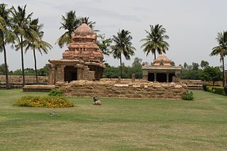
Ariyalur district District in Tamil Nadu, India

Ariyalur district is an administrative district in the state of Tamil Nadu in India. The district headquarters is located at Ariyalur. The district encompasses an area of 1,949.31 km².

India Country in South Asia

India is a country in South Asia. It is the seventh-largest country by area, the second-most populous country, and the most populous democracy in the world. Bounded by the Indian Ocean on the south, the Arabian Sea on the southwest, and the Bay of Bengal on the southeast, it shares land borders with Pakistan to the west; China, Nepal, and Bhutan to the north; and Bangladesh and Myanmar to the east. In the Indian Ocean, India is in the vicinity of Sri Lanka and the Maldives; its Andaman and Nicobar Islands share a maritime border with Thailand and Indonesia.

Tamil Nadu State in Southern India

Tamil Nadu, is one of the 29 states of India. Its capital and largest city is Chennai. Tamil Nadu lies in the southernmost part of the Indian subcontinent and is bordered by the union territory of Puducherry and the South Indian states of Kerala, Karnataka, and Andhra Pradesh. It is bounded by the Eastern Ghats on the north, by the Nilgiri Mountains, the Meghamalai Hills, and Kerala on the west, by the Bay of Bengal in the east, by the Gulf of Mannar and the Palk Strait on the southeast, and by the Indian Ocean on the south. The state shares a maritime border with the nation of Sri Lanka.

Demographics

As of 2001 India census, [1] Varadarajanpettai had a population of 8574. Males constitute 44% of the population and females 56%. Varadarajanpettai has an average literacy rate of 69%, higher than the national average of 59.5%: male literacy is 71%, and female literacy is 66%. In Varadarajanpettai, 12% of the population is under 6 years of age. There are 5 schools and a college. Include 2 higher secondary school, 1 matriculation school and 2 elementary school. There Don Bosco hr.sec.school had completed golden jubilee.

Census Acquiring and recording information about the members of a given population

A census is the procedure of systematically acquiring and recording information about the members of a given population. This term is used mostly in connection with national population and housing censuses; other common censuses include traditional culture, business, supplies, and traffic censuses. The United Nations defines the essential features of population and housing censuses as "individual enumeration, universality within a defined territory, simultaneity and defined periodicity", and recommends that population censuses be taken at least every 10 years. United Nations recommendations also cover census topics to be collected, official definitions, classifications and other useful information to co-ordinate international practices.

Related Research Articles

Bhogpur city in Punjab, India

Bhogpur is a town and a nagar panchayat in Jalandhar district in the state of Punjab, India. Bhogpur is the first city from the overall india who created its own website on city name. Bhogpur sugar mill is first Co-operative sugar mill and still running successfully.

Bishnah town in Jammu and Kashmir, India

Bishnah is a town and a notified area committee in Jammu district in the state of Jammu & Kashmir, India.

Desur town panchayat in Tamil Nadu, India

Desur is a Town panchayat in Tiruvanamalai district in the Indian state of Tamil Nadu.

Dwarahat town in Uttarakhand, India

Dwarahat is a town and a nagar panchayat in Almora district in the state of Uttarakhand, India.

Hirapur, Balaghat city in Madhya Pradesh, India

Hirapur is a census town in Balaghat district in the Indian state of Madhya Pradesh.

Kandukur, Prakasam district Town in Andhra Pradesh, India

Kandukur or Kandukuru is a town in Prakasam district of the Indian state of Andhra Pradesh. It is a municipality and the mandal headquarters of Kandukur mandal in Kandukur revenue division.

Khawhai city in Mizoram, India

Khawhai is a census town in Champhai district in the Indian state of Mizoram.

Kothavalasa Census Town in Andhra Pradesh, India

Kothavalasa is a census town in Vizianagaram district of the Indian state of Andhra Pradesh. It is located in Kothavalasa mandal of Vizianagaram revenue division. It is located 30 km from City Visakhapatanam

Nagla town in Uttarakhand, India

Nagla is a census town in Udham Singh Nagar district in the Indian state of Uttarakhand.

Pallipattu town in Tamil Nadu, India

Pallipattu is a town in Tiruvallur district in the state of Tamil Nadu, India. It is located 113 kilometres from Chennai, 40 kilometres from Chittoor, 51 kilometres from Tirupathi, 36 kilometres from Tiruttani, 50 kilometres from Arakkonam and border place of the state of Andhra Pradesh

Panagar Town in Madhya Pradesh, India

Panagar is a town with municipality in Jabalpur district in the Indian state of Madhya Pradesh.

Shahgarh city in Madhya Pradesh, India

Shahgarh is a town and a tahsil in Sagar district in the Indian state of Madhya Pradesh. Its connected with National Highway No. 86 Route, National Highway 539 and MP SH 37.

Shaktigarh town in Uttarakhand, India

Shaktigarh or Shaktifarm is a town and a nagar panchayat in Udham Singh Nagar district in the Indian state of Uttarakhand.

Sonatikiri Census Town in West Bengal, India

Sonatikiri is a census town in Gaighata CD Block of Bangaon subdivision in North 24 Parganas district in the Indian state of West Bengal.

Thondi or Tondi is a Panchayat town in Ramanathapuram district in the Indian state of Tamil Nadu. It is believed to be an ancient port site of Pandiyan kingdom. The famous Sri Sarvatheertheswarar Temple at Marungur, Theerthandathanam is located little northerly to Thondi.

Uttar Pirpur Census Town in West Bengal, India

Uttar Pirpur is a census town in Uluberia II CD Block of Uluberia subdivision in Howrah district in the Indian state of West Bengal. It is a part of Kolkata Urban Agglomeration.

Valvaithankoshtam is a panchayat town in Kanniyakumari district in the Indian state of Tamil Nadu.

Vengathur is a census town in Thiruvallur district in the Indian state of Tamil Nadu.

Vikravandi town in Tamil Nadu, India

Vikravandi is a town in Viluppuram district in the Indian state of Tamil Nadu.

Shahpura, Jabalpur city in Madhya Pradesh, India

Shahpura is a town and a nagar panchayat in Jabalpur district in the Indian state of Madhya Pradesh.

References

  1. "Census of India 2001: Data from the 2001 Census, including cities, villages and towns (Provisional)". Census Commission of India. Archived from the original on 16 June 2004. Retrieved 1 November 2008.

Coordinates: 11°22′06″N79°25′49″E / 11.36833°N 79.43028°E / 11.36833; 79.43028

Geographic coordinate system Coordinate system

A geographic coordinate system is a coordinate system that enables every location on Earth to be specified by a set of numbers, letters or symbols. The coordinates are often chosen such that one of the numbers represents a vertical position and two or three of the numbers represent a horizontal position; alternatively, a geographic position may be expressed in a combined three-dimensional Cartesian vector. A common choice of coordinates is latitude, longitude and elevation. To specify a location on a plane requires a map projection.