External links
വഴയില
| | This article related to a location in Thiruvananthapuram district, Kerala, India is a stub. You can help Wikipedia by expanding it. |
Vazhayila is an prime city near Peroorkada. Located at Trivandrum District. The exact location is 2 to 3 kilometers from the kowdiar Palace. It comes under Vattiyoorkavu constituency. Vazhayila has 4-lane road, Petrol pumps, Car showroom, Sports club, Corporation water facility, High speed internet, Online Taxi and food services etc.. There are various shopping centers, Many Flat and villa Projects in it.
The famous Killi river, which is a tributary of thw Karamana river, passes through Vazhayila.
It has an Auto rickshaw stand in the junction itself and a bus stop.
Vazhayila is connected via Thiruvananthapuram-Thenmala Highway (S.H) to various places inside and outside the district like Karakulam, Nedumangad, Palode, Thenmala, Kuttalam etc. It also connects different places of Tamil Nadu like Thenkasi.
The city roads connect important places Peroorkada, Vattiyoorkavu, Aruvikkara, Mannanthala etc.
വഴയില
| | This article related to a location in Thiruvananthapuram district, Kerala, India is a stub. You can help Wikipedia by expanding it. |
Nedumangad is a town and municipality in Thiruvananthapuram metropolitan area of Thiruvananthapuram district in the Indian state of Kerala, and is the headquarters of Nedumangad tehsil and Nedumangad Revenue Division (RDO). It is a suburb of the extended metropolitan region of Thiruvananthapuram city. It is located around 16 km to the north-east of Thiruvananthapuram city on the Thiruvananthapuram – Shenkottah. It is an important commercial center in the district. It is a growing commercial and educational hub and all important government institutions are situated in the town. Nedumangadu Market is important in South Kerala.

Punalur is a Municipality in Kollam district of Kerala State in India. It is the headquarter of the Punalur Taluk and Punalur Revenue Division. It's situated in the eastern part of Kollam district of Kerala, on the banks of the Kallada River and foothills of the western ghats. It is about 45 kilometres (28 mi) north-east of Kollam and 68 kilometres (42 mi) north of Thiruvananthapuram.Punalur is also Known as Mini Pamba, Lap of the Western Ghat, and Gateway of Sabarimala.
Kollam district, is one of 14 districts of the state of Kerala, India. The district has a cross-section of Kerala's natural attributes; it is endowed with a long coastline, a major Laccadive Sea seaport and an inland lake. The district has many water bodies. Kallada River is one among them, and the east side land of river is East Kallada and the west side land is West Kallada.
The Main Central Road, better known as MC Road is the arterial State Highway starting from Kesavadasapuram in Trivandrum city and ends at Angamaly, a suburb of Kochi city in Ernakulam District, in the state of Kerala, India. It is designated as State Highway 1 by the Kerala Public Works Department. The highway was built by Raja Kesavadas, Dewan of Travancore.

Thiruvananthapuram Municipal Corporation is the oldest and the largest city corporation in the Kerala state of India. It is the municipal corporation that administrates the city of Thiruvananthapuram (Trivandrum), the capital of Kerala. The city corporation is spread over 214.86 km2 with 100 wards and a population of 9,57,730 inhabitants. It includes the Legislative Assembly constituencies of Thiruvananthapuram, Vattiyoorkavu, Nemom, Kazhakkoottam and 5 wards of the Kovalam constituency. Mayor Arya Rajendran is presently the youngest mayor in the country.Thiruvananthapuram has been formed with functions to improve the infrastructure of town.

Thenmala is a tourist destination in the eastern side of Kollam district in Kerala, India that is home to the first eco-tourism centre in India. The word 'Thenmala' means "'Honey hills" in Malayalam language. The town is 66 km away from Kollam city and is just 14 km away from Tamil Nadu state border. The interstate National Highway-744, connecting Kollam with Madurai in Tamil Nadu, and State Highway-2 of Kerala are passing through Thenmala.
Vattiyoorkavu is located in the north-eastern side of Thiruvananthapuram (Trivandrum) city, Kerala, India. Killi River and Karamana River flows through this area. It is one among the four legislative constituencies which are a part of Thiruvananthapuram city and is represented in the Kerala Legislative Assembly by Adv. V. K. Prasanth. It is one of the most important residential suburbs of the city and is an important link in connecting the city with several outer areas such as Kachani, Aruvikkara, Puliyarakonam, etc. It is a comparatively high-lying area of the city. Vattiyoorkavu is one of the greenest parts of the city. Other important area nearby Vattiyoorkavu are Maruthamkuzhi, Sasthamangalam, Elippodu, Kulasekharam etc. It comes under the jurisdiction of Vattiyoorkavu police station which is located in Vattiyoorkavu junction. Vattiyoorkavu has its own post office (PIN-695013), telecom Exchange and electricity (KSEB) section as well. There are regular buses to Kizhakekotta as well as other areas of the city which pass through the Vattiyoorkavu bus stop. Two auto stands and one taxi stand are also present near the junction.

Kulathupuzha is a town to the eastern part of Kollam district of Kerala, India. It is one of the important pilgrim spots linked with the legend of Sabarimala. Kulathupuzha is also the birthplace of the Malayalam music legend Raveendran.Kulathupuzha is the source of the Kallada river, Thenmala Dam(KIP) is located on this river.

Aryankavu is a village located in the Kollam district of the South Indian state of Kerala. It lies close to the border between Kerala and Tamil Nadu near Thenmala. It is also one of the famous pilgrimage sites associated with the legend of Sabarimala. The village is located besides Shendurney Wildlife Sanctuary.
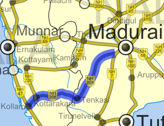
National Highway 744 or NH 744 is a National Highway in Southern India that links Kollam (Quilon) in Kerala with Madurai in Tamil Nadu. Starting from NH 66 at Chinnakkada in Kollam, it joins Tirumangalam in Madurai at National Highway 44 (India).

Palode is a town in Thiruvananthapuram district in the Indian state of Kerala. Palode town is 35 km (22 mi) from Thiruvananthapuram city and 17 km (11 mi) from Nedumangad municipality.There is a Helipad in palode. Palode is surrounded by Western Ghats. Jawaharlal Nehru Tropical Botanic Garden and Research Institute is situated near Palode. Mankayam Ecotourism near Brimore is 11 km (6.8 mi) away. Brimore has tea estate and plantations make Palode a gateway for tourism destination.Thenmala is 38 km (24 mi) from Palode and Ponmudi hills is 35 km. Palode is town in Thiruvananthapuram-Thenmala -Shenkottai State Highway 2 (Kerala). Tenkasi is 75 km (47 mi) from Palode. Palode is a town located in Nedumangad Taluk of Thiruvananthapuram district in Kerala.
Puthoorkonam is 1 km from Vattiyoorkavu in the Vattiyoorkavu-Peroorkada route, in Thiruvananthapuram, Kerala, India. Puthoorkonam is famous for the Devi Temple. A beautiful place surrounded by trees
Mannanmoola is a residential locality near Peroorkada to the north eastern part of Thiruvananthapuram (Trivandrum) in the Indian state of Kerala, on the way to vattiyoorkavu. Once a remote village, Mannanmoola has seen rapid development over the last decade with the setting up of several residential colonies. Mannanmoola has one boundary demarked by the Killi River, which is crossed by the Mannanmoola Bridge en route to Vattiyoorkavu. The other localities in Mannanmoola's neighbourhood are Melathumele, Manikanteswaram, Thozhuvancodu, Oolampara etc. This area is part of Peroorkada Ward of the Corporation of Thiruvananthapuram and the elected Ward member is Mrs.P.Jameela Sreedharan.

Kowdiar is one of the main localities in the city of Trivandrum, Kerala, India. It is one of the most expensive and cleanest localities in Trivandrum. It is the starting point of the Rajapatha that stretches till the East Fort. It lies between the localities of Vellayambalam and Peroorkada- a suburb in the vicinity.
State Highway 2 is a State Highway in Kerala, India that starts from Thiruvananthapuram Peroorkada and ends near Thenmala Kollam by joining with Kollam-Tirumangalam NH-744. The highway is 73.2 km long. The major towns in this highway are Nedumangad, Palode and Kulathupuzha.It is a major road connecting Thiruvananthapuram the Capital City of Kerala to Tamil Nadu. In 2016 NHAI approved in principle this road as National highway.
The Indian city of Thiruvananthapuram has a well-developed transport infrastructure. The city and its suburbs may be traversed using road and rail. Within the city, city buses, taxis and auto rickshaws provide mobility. Scooters and motorcycles are the favored means of personal transport. Ola, Uber and other taxi services operate there.
Thiruvananthapuram Taluk is a Taluk (tehsil) in Thiruvananthapuram district in the Indian state of Kerala. It is the most populous taluk in the district and one of most populous in Kerala. It is situated in the western part of the Thiruvananthapuram district.

Vilakkupara is a village in Punalur Taluk, Kollam District, Kerala State, India. Vilakkupara lies 58 km (36 mi) to the east of Kollam, the District headquarters, and 12 km (7 mi) to the southeast of Punalur on Kollam-Thirumangalam National Highway (N.H-744). It is 72 km (45 mi) north of Thiruvananthapuram, the State Capital. It belongs to the Yeroor Gram panchayat, Punalur Assembly Constituency, and is a part of the Kollam Lok Sabha constituency.
Kudappanakunnu is the headquarters of Thiruvananthapuram district in the Indian state of Kerala.