
A swamp is a forested wetland. Swamps are considered to be transition zones because both land and water play a role in creating this environment. Swamps vary in size and are located all around the world. The water of a swamp may be fresh water, brackish water, or seawater. Freshwater swamps form along large rivers or lakes where they are critically dependent upon rainwater and seasonal flooding to maintain natural water level fluctuations. Saltwater swamps are found along tropical and subtropical coastlines. Some swamps have hammocks, or dry-land protrusions, covered by aquatic vegetation, or vegetation that tolerates periodic inundation or soil saturation. The two main types of swamp are "true" or swamp forests and "transitional" or shrub swamps. In the boreal regions of Canada, the word swamp is colloquially used for what is more formally termed a bog, fen, or muskeg. Some of the world's largest swamps are found along major rivers such as the Amazon, the Mississippi, and the Congo.
Ecological classification or ecological typology is the classification of land or water into geographical units that represent variation in one or more ecological features. Traditional approaches focus on geology, topography, biogeography, soils, vegetation, climate conditions, living species, habitats, water resources, and sometimes also anthropic factors. Most approaches pursue the cartographical delineation or regionalisation of distinct areas for mapping and planning.
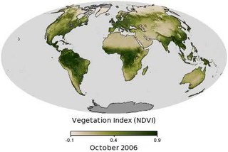
Vegetation is an assemblage of plant species and the ground cover they provide. It is a general term, without specific reference to particular taxa, life forms, structure, spatial extent, or any other specific botanical or geographic characteristics. It is broader than the term flora which refers to species composition. Perhaps the closest synonym is plant community, but vegetation can, and often does, refer to a wider range of spatial scales than that term does, including scales as large as the global. Primeval redwood forests, coastal mangrove stands, sphagnum bogs, desert soil crusts, roadside weed patches, wheat fields, cultivated gardens and lawns; all are encompassed by the term vegetation.

The nutria, also known as the coypu, is a large, herbivorous, semiaquatic rodent. Classified for a long time as the only member of the family Myocastoridae, Myocastor is now included within Echimyidae, the family of the spiny rats. The nutria lives in burrows alongside stretches of water, and feeds on river plant stems. Originally native to subtropical and temperate South America, it has since been introduced to North America, Europe, Asia, and Africa, primarily by fur farmers. Although it is still hunted and trapped for its fur in some regions, its destructive burrowing and feeding habits often bring it into conflict with humans, and it is considered an invasive species. Nutria also transmit various diseases to humans and animals mainly through water contamination.

The Salton Sea State Recreation Area offers hunting, fishing, swimming, and camping to visitors on the northeastern side of the Salton Sea.
Laguna Atascosa National Wildlife Refuge is the largest protected area of natural habitat left in the Lower Rio Grande Valley. The 98,000-acre (400 km2) refuge is located almost entirely in Cameron County, Texas, although a very small part of its northernmost point extends into southern Willacy County.

The tricolored blackbird is a passerine bird of the family Icteridae. Its range is limited to the coastal areas of the Pacific coast of North America, from Northern California in the U.S., to upper Baja California in Mexico.

Palustrine wetlands include any inland wetland that contains ocean-derived salts in concentrations of less than 0.5 parts per thousand, and is non-tidal. The word palustrine comes from the Latin word palus or marsh. Wetlands within this category include inland marshes and swamps as well as bogs, fens, pocosins, tundra and floodplains.
The Seal Beach National Wildlife Refuge is a wildlife refuge encompassing 965 acres (3.91 km2) located in the California coastal community of Seal Beach. Although it is located in Orange County it is included as part of the San Diego National Wildlife Refuge Complex. It was established in 1972.

The Yolo Bypass Wildlife Area is located within the Yolo Bypass in Yolo County, California. The wildlife area is managed by the California Department of Fish and Wildlife with the intent of restoring and managing a variety of wildlife habitats in the Yolo Basin, a natural basin in the north part of the Sacramento-San Joaquin River Delta. The creation of the wildlife area was spearheaded by the Yolo Basin Foundation. The California Department of Fish and Wildlife and Yolo Basin Foundation are the core partners in the operation of this unique community resource. Located at 38.550515°N 121.626291°W

The E. E. Wilson Wildlife Area is a wildlife management area located near Corvallis, Oregon, United States. The site was named for Eddy Elbridge Wilson, a member of the former Oregon State Game Commission for fourteen years before his death in 1961. Wildlife visible includes blacktail deer, pheasant, and quail.

Geographic Information Systems (GIS) has become an integral part of aquatic science and limnology. Water by its very nature is dynamic. Features associated with water are thus ever-changing. To be able to keep up with these changes, technological advancements have given scientists methods to enhance all aspects of scientific investigation, from satellite tracking of wildlife to computer mapping of habitats. Agencies like the US Geological Survey, US Fish and Wildlife Service as well as other federal and state agencies are utilizing GIS to aid in their conservation efforts.
The National Wetlands Inventory (NWI) was established by the United States Fish and Wildlife Service (FWS) to conduct a nationwide inventory of U.S. wetlands to provide biologists and others with information on the distribution and type of wetlands to aid in conservation efforts. To do this, the NWI developed a wetland classification system that is now the official FWS wetland classification system and the Federal standard for wetland classification. The NWI also developed techniques for mapping and recording the inventory findings. The NWI relies on trained image analysts to identify and classify wetlands and deepwater habitats from aerial imagery. NWI started mapping wetlands at a small scale. Eventually, large-scale maps became the standard product delivered by NWI. As computerized mapping and geospatial technology evolved, NWI discontinued production of paper maps in favor of distributing data via online "mapping tools" where information can be viewed and downloaded. Today, FWS serves its data via an on-line data discovery "Wetlands Mapper". GIS users can access wetlands data through an online wetland mapping service or download data for various applications. The techniques used by NWI have recently been adopted by the Federal Geographic Data Committee as the federal wetland mapping standard. This standard applies to all federal grants involving wetland mapping to insure the data can be added to the Wetlands Layer of the National Spatial Data Infrastructure. NWI also produces national wetlands status and trends reports required by the United States Congress.

The Yanga National Park is a newly formed national park, located near the township of Balranald in south- western New South Wales. It covers an area of 66,734 hectares which includes 1,932 hectares of Yanga Nature Reserve, and has a frontage of 170 kilometres (110 mi) on the Murrumbidgee River. It is largely located in the Lower Murrumbidgee Floodplain, which is included on A Directory of Important Wetlands in Australia because of its importance as a breeding site for waterbirds when flooded.

Blue Ridge National Wildlife Refuge is located in the Sierra Nevada, in Tulare County, California. The refuge is one of four units of the Hopper Mountain National Wildlife Refuge Complex for California condors.

The North American beaver had a historic range that overlapped the Sierra Nevada in California. Before the European colonization of the Americas, beaver were distributed from the arctic tundra to the deserts of northern Mexico. The California Golden beaver subspecies was prevalent in the Sacramento and San Joaquin River watersheds, including their tributaries in the Sierra Nevada. Recent evidence indicates that beaver were native to the High Sierra until their extirpation in the nineteenth century.
The Ana River is a short spring-fed river in south-central Oregon. It is on the northwestern edge of the Great Basin drainage. It flows 7 miles (11 km) from springs at the foot of Winter Ridge through high desert, range, and wetlands before emptying into Summer Lake. For most of its course, the Ana River flows through the Summer Lake Wildlife Area, which is maintained by the Oregon Department of Fish and Wildlife. The river provides habitat for many mammal and bird species, as well as several fish species, including the rare Summer Lake Tui chub. The largest hybrid striped bass ever caught in Oregon was taken from Ana Reservoir in 2009.

The Summer Lake Wildlife Area is a 29.6-square-mile (77 km2) wildlife refuge located on the northwestern edge of the Great Basin drainage in south-central Oregon. It is administered by the Oregon Department of Fish and Wildlife. The refuge is an important stop for waterfowl traveling along the Pacific Flyway during their spring and fall migrations. The Summer Lake Wildlife Area also provides habitat for shorebirds and other bird species as well as wide variety of mammals and several fish species. The Ana River supplies the water for the refuge wetlands.
Todd Keeler-Wolf is a California botanist and ecologist who co-developed the "Sawyer and Keeler-Wolf classification system" of vegetation types.
Ponkapag Pond is a 203-acre impoundment in the Blue Hills Reservation. The pond is located on the border of Canton and Randolph, Massachusetts about a half mile south of Route 128 and a half mile east of Route 138. It has a maximum depth of seven feet and an average depth of four feet. As would be expected on a pond this shallow, aquatic vegetation is pervasive and very abundant. Only a small portion of the eastern shoreline is developed; the southeastern and western shores are bordered by large expanses of marshland. A walking trail circles the pond, with parking at three locations.