Franconia is a region of Germany, characterised by its culture and Franconian dialect.
Bayreuth is a Landkreis (district) in Bavaria, Germany. It surrounds, but does not include the city of Bayreuth. The district is bounded by the districts of Kulmbach, Hof, Wunsiedel, Tirschenreuth, Neustadt an der Waldnaab, Amberg-Sulzbach, Nürnberger Land, Forchheim and Bamberg.

The Bavarian Forest is a wooded, low-mountain region in Bavaria, Germany that is about 100 kilometres long. It runs along the Czech border and is continued on the Czech side by the Bohemian Forest. Most of the Bavarian Forest lies within the province of Lower Bavaria, but the northern part lies within Upper Palatinate. In the south it reaches the border with Upper Austria.
Forchheim is a Landkreis (district) in Bavaria, Germany. It is bounded by the districts of Bamberg, Bayreuth, Nürnberger Land and Erlangen-Höchstadt.
Landsberg is a Landkreis (district) in Bavaria, Germany. It is bounded by the districts of Aichach-Friedberg, Fürstenfeldbruck, Starnberg, Weilheim-Schongau, Ostallgäu and Augsburg.
Neustadt (Aisch)-Bad Windsheim is a Landkreis (district) in Bavaria, Germany. It is bounded by the districts of Würzburg, Kitzingen, Bamberg, Erlangen-Höchstadt, Fürth and Ansbach, and by the state of Baden-Württemberg.
Nürnberger Land is a Landkreis (district) in Bavaria, Germany. It is bounded by the districts of Forchheim, Bayreuth, Amberg-Sulzbach, Neumarkt, Roth and Erlangen-Höchstadt, and by the city of Nuremberg.

The Pegnitz is a river in Franconia in the German federal state of Bavaria.

Germany is a country in Central Europe, that stretches from the Alps, across the North European Plain to the North Sea and the Baltic Sea. It is the second-most populous country in Europe after Russia, and is seventh-largest country by area in the continent. The territory of Germany covers 357,021 km2 (137,847 sq mi), consisting of 349,223 km2 (134,836 sq mi) of land and 7,798 km2 (3,011 sq mi) of waters.

The Steinwald is a mountain range up to 946 m above sea level (NN) in southern Germany and, at the same time, a nature park founded in 1970 with an area of 246 square kilometres (95 sq mi) in the province of Upper Palatinate, in North Bavaria.
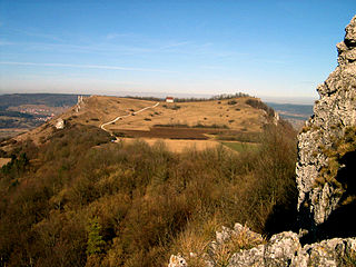
The Ehrenbürg is a double-peaked butte on the edge of the Franconian Jura in Bavaria, Germany. It is in the district of Forchheim in Upper Franconia, in the municipalities of Kirchehrenbach, Leutenbach and Wiesenthau. The north peak is the 513.9 m Walberla, the south peak the 531.7 m Rodenstein. The hill is popularly known as the Walberla.

The Nuremberg–Cheb railway is a 151 km long, non-electrified main line, mainly in the German state of Bavaria. It runs from Nuremberg via Lauf an der Pegnitz, Hersbruck, Pegnitz, Kirchenlaibach, Marktredwitz and Schirnding to Cheb in the Czech Republic. The route is also known as the RightPegnitz line (German: rechte Pegnitzstrecke or the Pegnitz Valley Railway. It was built as the Fichtel Range Railway. The Nuremberg–Schnabelwaid section of it is part of the Saxon-Franconian trunk line.

On 8 March 1988 the Bavarian State Ministry for State Development and the Environment designated an area of 1,280 square kilometres (490 sq mi) in the Steigerwald in North Bavaria, Germany, as the Steigerwald Nature Park. About half the area consists of protected landscapes. The nature park is run by the Steigerwald Tourist Association and Steigerwald Nature Park.
The Saar-Nahe Hills or Saar-Nahe Uplands is a major natural region in the German states of Rhineland-Palatinate and the Saarland. The region of hills and mountains covers an area of 4,185 km² running from Saarbrücken, Kaiserslautern and the Palatine Forest in the south to the Hunsrück in the northeast. It contains the catchment area of the Nahe as far as Bad Kreuznach as well as small sections of the Middle Saar in the west.

The Volcanic Eifel Nature Park lies in the counties of Bernkastel-Wittlich, Cochem-Zell and Vulkaneifel in the German state of Rhineland-Palatinate. The nature park, which is in the Eifel mountains, and which is also a geopark, was inaugurated on 31 May 2010 and has an area of 1,068.24 km².> Its sponsor is the Natur- und Geopark Vulkaneifel GmbH.

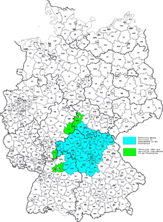
Franconian Switzerland-Veldenstein Forest Nature Park is a nature park in North Bavaria. The nature park was established in 1995 and it covers an area that is almost coextensive with the natural region major unit of Northern Franconian Jura, the park being slightly larger.
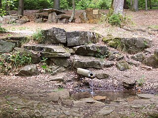
The Red Main Spring is the source of the Red Main river, the left-hand and southern headstream of the River Main in Germany. It is located in the Lindenhardt Forest, ten kilometres south of Bayreuth near Hörlasreuth at a height of 581 m above sea level (NN) on the southern slopes of the Tannenberg (596 m). Although the Red Main is several kilometres longer than the Weiße Main, the stronger White Main Spring is seen as the source of the Main itself.

The burgstall of the Altes Schloss is the site of an old castle near the village of Affalterthal in Bavaria, that was probably built in the High Middle Ages for the nobility. It lies within the municipality of Egloffstein in the Upper Franconian county of Forchheim.
The Lange Meile is a plateau in the Franconian Jura in south Germany which is up to about 517 m above sea level (NHN). It lies within the region of Franconian Switzerland in the Upper Franconian county of Forchheim in the state of Bavaria.

The Alarmstange, at 545.2 m above sea level (NHN), is the highest point in the Montabaur Heights, a hill ride on the southwestern edge of the Westerwald. It lies near Horressen in the county of Westerwaldkreis in the German state of Rhineland-Palatinate. Together with the Köppel and the Lippersberg, the Alarmstange forms the centre of the ridge, on which is the largest contiguous woodland area in the Westerwald.

