
Alt Urgell is a comarca (county) in Catalonia, Spain, a modern representation of part of the historic County of Urgell, seat of the Counts of Urgell and the historic region of Urgellet.
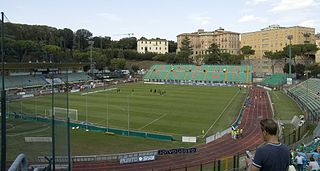
Stadio Artemio Franchi is a multi-purpose stadium in Siena, Italy. It is currently used mostly for football matches and the home of A.C. Siena. The stadium was built in 1923 and holds 15,373.

Blissestraße is a Berlin U-Bahn station located on the U 7. Designed by G. R. Rümmler and opened in 1971, it has a ceiling with cement caskets that reflect the light in an unusual way.

Kamianka-Dniprovska is a city in Zaporizhia Oblast, Ukraine. It serves as the administrative center of Kamianka-Dniprovska raion. Population: 13,495 (2013 est.).
Mandakh is a sum (district) of Dornogovi Province in south-eastern Mongolia.

Domasławice is a village in the administrative district of Gmina Twardogóra, within Oleśnica County, Lower Silesian Voivodeship, in south-western Poland. Prior to 1945 it was in Germany.

Jugowice is a village in the administrative district of Gmina Walim, within Wałbrzych County, Lower Silesian Voivodeship, in south-western Poland.
Dobryszyce is a village in Radomsko County, Łódź Voivodeship, in central Poland. It is the seat of the gmina called Gmina Dobryszyce. It lies approximately 10 kilometres (6 mi) north of Radomsko and 71 km (44 mi) south of the regional capital Łódź.
Bobry is a village in the administrative district of Gmina Radomsko, within Radomsko County, Łódź Voivodeship, in central Poland. It lies approximately 6 kilometres (4 mi) south-west of Radomsko and 85 km (53 mi) south of the regional capital Łódź.
Przydworzyce is a village in the administrative district of Gmina Magnuszew, within Kozienice County, Masovian Voivodeship, in east-central Poland. It lies approximately 6 kilometres (4 mi) south of Magnuszew, 19 km (12 mi) north-west of Kozienice, and 63 km (39 mi) south-east of Warsaw.
Kuszlów is a village in the administrative district of Gmina Policzna, within Zwoleń County, Masovian Voivodeship, in east-central Poland. It lies approximately 12 kilometres (7 mi) north-east of Zwoleń and 103 km (64 mi) south-east of Warsaw.
Gzowice-Folwark is a village in the administrative district of Gmina Jedlnia-Letnisko, within Radom County, Masovian Voivodeship, in east-central Poland.
Pogorzele is a village in the administrative district of Gmina Stary Dzierzgoń, within Sztum County, Pomeranian Voivodeship, in northern Poland. It lies approximately 9 kilometres (6 mi) north of Stary Dzierzgoń, 25 km (16 mi) east of Sztum, and 71 km (44 mi) south-east of the regional capital Gdańsk.
Xuân Hương is a commune (xã) and village in Lạng Giang District, Bắc Giang Province, in northeastern Vietnam.
Refuge du Pelvoux is a refuge in the Alps.

Crni Vrh is a village in the municipality of Čelinac, Republika Srpska, Bosnia and Herzegovina.
Stolac is a village in the municipality of Višegrad, Bosnia and Herzegovina.
Suyang Township is a township-level division of Yuanshi County, Shijiazhuang, Hebei, China.
East Winthrop is a village in the town of Winthrop in Kennebec County, Maine, United States. It is located just west of Manchester and south of Readfield, borders most of Cobbosseecontee Lake, and all of Little Cobbosseecontee, Upper & Lower Narrows. It has a separate post office and ZIP code (04343) from the rest of Winthrop, although this serves only mail delivered to post office boxes in the East Winthrop Post Office. The area has magnificent views of the Cobbosseecontee bodies of water.

Yellowbanks is an unincorporated community in Tippecanoe Township, Kosciusko County, in the U.S. state of Indiana.


