Kilakarai is a municipality in Ramanathapuram district in the Indian state of Tamil Nadu. As of 2011, the town had a population of 38,355. Kilakarai is one of the Taluka in Ramanathapuram District.
Keeranur 624617 is a panchayat town in Dindigul district in the Indian state of Tamil Nadu. It is situated between Palani and Dharapuram. There are more than three places in Tamil Nadu and in the rest of India with the same name, a bigger Keeranur situated near Trichy.
Kottuvally is a census town near Paravoor. It is also a village in Paravur Taluk, Ernakulam district in the Indian state of Kerala. It is situated towards the southern part of the taluk. The nearest town is North Paravur, 4 km away. The panchayat of Kottuvally is spread out on both sides of Panvel - Kochi - Kanniyakumari Highway

Mallasamudram is a Panchayath town in Thiruchengode taluk, Namakkal district in the Indian state of Tamil Nadu. It is the headquarter of the Mallasamudram block. Mallasamudram is also known as "Mallai Managaram", "Mallai".
Marakkanam is a coastal panchayat town & Taluk in Viluppuram district in the Indian state of Tamil Nadu. It is well connected to the state capital Chennai and the nearby union territory of Puducherry by the East Coast Road. To the west, Marakkanam is connected to the town of Tindivanam by the SH-134. Marakkanam is situated on the declared National Waterways NW-4. On materialisation of National Waterways NW-4, Marakkanam will be connected to two states Andhra Pradesh (Kakinada) and Puducherry through north and south of Buckingham Canal.

Nannilam is a Town and Taluk in Thiruvarur District in the Indian state of Tamil Nadu. It is the headquarters town for Nannilam Taluk.

Nattarasankottai is a village in Sivaganga district in the Indian state of Tamil Nadu.
Neikkarapatti is a panchayat town in Dindigul district in the Indian state of Tamil Nadu.
Pullambadi is a Panchayat town in Tiruchirappalli district in the Indian state of Tamil Nadu. Pullambadi town panchayat heads the revenue block of Pullambadi in the taluk of Lalgudi.
Thenkarai is a suburban area near Coimbatore City Municipal Corporation, in the Indian state of Tamil Nadu. It is in the western suburbs of Coimbatore. It recently merged with the Coimbatore Corporation limits. Thenkarai is one of the town panchayats in Coimbatore and consists of small villages such as Sennanur, Mathipalayam, Karadimadai, Thaneer Panthal, Appachimaar Kovil, Challikkuzhi and KrishnaPuram Pudur.
Thingalnagar is the town panchayat, located in Kanniyakumari district in the Indian state of Tamil Nadu.

Uppidamangalam is a panchayat town in Karur district in the Indian state of Tamil Nadu.
T. Vadipatti is a panchayat town in the Madurai district in the Indian state of Tamil Nadu.and also known as "west gateway of Madurai.

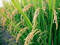
Varappuzha, IPA:[ʋɐɾɐːpːuɻɐ], is a northern suburb of the city of Kochi. It is a census town in Paravur Taluk, Ernakulam district in the Indian state of Kerala. Situated around 15 km (9 mi) from the city centre and 8 km (5 mi) from Edapally, the areas lies in the NH 66 connecting Vytilla with North Paravur. Its specialty is that considerably large-scale paddy cultivating area is situating western part of Varapuzha which is called Devaswompadam, specialised with Pokkali paddy cultivation and interim crop as fish cultivation locally called 'Kettu'. The common work of the natives are fishing and agriculture. Varapuzha is known for its fish market.

Athani is a panchayat town located about 13 km from Gobichettipalayam in Anthiyur taluk of Erode district in the state of Tamil Nadu, India.
Bhuvanagiri is a Taluka in the Cuddalore district of the Indian state of Tamil Nadu. It is the birthplace of a South Indian saint, Sri Raghavendra Swami and is close to Maruthur, the birthplace of Saint Ramalinga Adigalar.
Rajiana is a village of Malwa region in District Moga, Punjab. The village is divided into pattis like Vigha patti, Narang ki patti, Haveli patti, Joga Patti, Ghoga Patti, Wazir patti, Rania Patti etc. The people of the village belongs to various religions, most of them are Jatt Sikhs of Brar clan. The village has three panchayats; Rajiana, Rajiana Patti Vigha and Rajiana Khurd. There are three water works and 3 water filters in the village supplying pure water to the villagers. There is a Co-operative bank, Revenue office, Corporate society for farmers, two petrol pumps, three Government schools, three private school, Government hospital, Government veterinary hospital, Multiplex and Hotel, two playgrounds, 5 mini parks, two marriage resorts, mobile towers and all other facilities.
Kadaladi in Tamil Nadu is 108 km from Madurai. Kadaladi is situated between Mudukulathur and Sayalgudi. It is a taluk headquarters and a revenue region of Ramanathapuram district.
Sukkangalpatti is a panchayat town in Theni district in the Indian state of Tamil Nadu.
R&R Colony Ponnathota is a smart village located in Jammalamadugu Mandal, Kadapa district, Andhra Pradesh, India. It falls under the constituency of Jammalamadugu and is situated along the bank of the Penna River. The Mylavaram dam, located just 3 km away, supplies drinking water to the area. R&R Colony Ponnathota is also known for its residents who create silk sarees with their own hands.