This article is being considered for deletion in accordance with Wikipedia's deletion policy. Please share your thoughts on the matter at this article's deletion discussion page.
Feel free to improve the article, but this notice must not be removed until the discussion is closed, and the article must not be blanked. For more information, particularly on merging or moving the article during the discussion, read the guide to deletion. Find sources:"Vercors Cave System"–news·newspapers·books·scholar·JSTOR%5B%5BWikipedia%3AArticles+for+deletion%2FVercors+Cave+System%5D%5DAFD
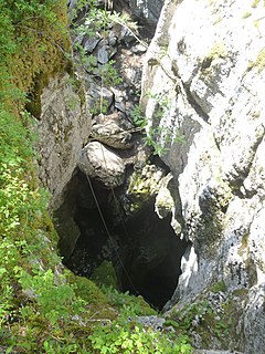
Part of the Cuves de Sassenage, in the cave system
The Vercors cave "system" is an Anglophone way of referring to the many long, narrow caves situated in the Vercors Massif, in South-Eastern France. The caves include the Bournillon cave, which has the highest cave entrance in Europe.[1]
The caves are located in the limestone area in the Rhône-Alpes region, in the lower Alps.[1]
History
The caves are well known to British explorers, since the expedition led by Ken Pierce in the early 1960s introduced them to the area.[2]
Description
Entrance of Bournillon, the highest cave entrance in Europe.
The total area with the caves extends to around 400 square miles (1000 square kilometres) with a depth of up to 1271 metres (4170feet). The surrounding area around the caves is the largest karst area in Europe. The caves are formed because of the Cretaceouslimestone throughout the caves, that is up to 400 metres (1300feet) thick at some points.[1]
The caves passages are a mix of large, old and dry tunnels, full of calcite deposits with narrow streamways and waterfalls.[1]
There are specific sets of caves because of the geology of the area, each with their own characteristics. In the north east (from the Moucherolle up to the Sornin Plateaux) the caves are regarded as very deep and very demanding in the grading system, especially considering the variable weather in the area. In the north west of the system, the caves (including the Autrans and Meaudre systems) are of current interest, as many new caving discoveries are being made, particularly in the Meaudre area, on a regular basis. Further south the caves vary in their characteristics, with systems in the Herbouilly Plateau being of different gradings. The area surrounding the Vernaison and its associated river valley contains many caves and systems, with one of the most explored being the Grotte de la Luire just south of Saint-Agnan-en-Vercors which is located at the Bournillon entrance, which is the largest cave entrance in Europe.[1][2]
Probably the most famous and deepest cave in the region is the Gouffre Berger cave. This cave includes the narrow shafts, descending into the Grand Galerie, which itself is home to very large and very old stalagmites. This particular system follows the slope of the limestone beds for 3 kilometres (1.9mi), until it meets the flooded area of the Cuves de Sassenage.[1][3]
On 23 May 1985, the skeleton of a young boy was found in the caves. Originally, he was believed to be the body of Ludovic Janvier, a boy who disappeared from Grenoble on 17 March 1983. Despite pleas from his family, especially his mother, his DNA has never been tested and he has yet to be identified. Ludovic has also never been found. [4][5]
Related Research Articles
A cave or cavern is a natural void in the ground, specifically a space large enough for a human to enter. Caves often form by the weathering of rock and often extend deep underground. The word cave can also refer to much smaller openings such as sea caves, rock shelters, and grottos, though strictly speaking a cave is exogene, meaning it is deeper than its opening is wide, and a rock shelter is endogene.
A canyon or gorge is a deep cleft between escarpments or cliffs resulting from weathering and the erosive activity of a river over geologic time scales. Rivers have a natural tendency to cut through underlying surfaces, eventually wearing away rock layers as sediments are removed downstream. A river bed will gradually reach a baseline elevation, which is the same elevation as the body of water into which the river drains. The processes of weathering and erosion will form canyons when the river's headwaters and estuary are at significantly different elevations, particularly through regions where softer rock layers are intermingled with harder layers more resistant to weathering.
The Vercors Massif is a range in France consisting of rugged plateaux and mountains straddling the départements of Isère and Drôme in the French Prealps. It lies west of the Dauphiné Alps, from which it is separated by the rivers Drac and Isère. The cliffs at the massif's eastern limit face the city of Grenoble.
The Highland Rim is a geographic term for the area in Tennessee surrounding the Central Basin. Nashville is largely surrounded by higher terrain in all directions.
Mont Aiguille is a mountain in the Vercors Massif of the French Prealps, located 58 km (36 mi) south of Grenoble, in the commune of Chichilianne, and the département of Isère. The mountain, known as one of the Seven Wonders of Dauphiné, is a relatively flat limestone mesa surrounded by steep cliffs. The mountain lies within an area designated in 1970 as the Vercors Regional Natural Park. Mont Aiguille's limestone cliffs, especially on the northwest side, are popular with climbers. Its first climb in 1492 was said to mark the birth of mountaineering.
The Eisriesenwelt is a natural limestone and ice cave located in Werfen, Austria, about 40 km south of Salzburg. The cave is inside the Hochkogel mountain in the Tennengebirge section of the Alps. It is the largest ice cave in the world, extending more than 42 km and visited by about 200,000 tourists every year.
The Marble Arch Caves are a series of natural limestone caves located near the village of Florencecourt in County Fermanagh, Northern Ireland. The caves are named after the nearby Marble Arch, a natural limestone arch at the upstream end of Cladagh Glen under which the Cladagh River flows. The caves are formed from three rivers draining off the northern slopes of Cuilcagh mountain, which combine underground to form the Cladagh. On the surface, the river emerges from the largest karst resurgence in Ireland, and one of the largest in the United Kingdom. At 11.5 kilometres (7.1 mi) the Marble Arch Caves form the longest known cave system in Northern Ireland, and the karst is considered to be among the finest in the British Isles.
The Gouffre Berger is a French cave discovered on 24 May 1953 by Joseph Berger, Bouvet, Ruiz de Arcaute and Marc Jouffray. From 1953 to 1963, it was regarded as the deepest cave in the world at −1,122 metres (−3,681 ft), relinquishing this title to the previous contender, Pierre Saint Martin, in 1964, after further exploration. The Gouffre Berger is now ranked 28th deepest cave in the world, and the 4th in France.
Autrans is a former commune in the Isère department in the Rhône-Alpes region of south-eastern France. On 1 January 2016, it was merged into the new commune of Autrans-Méaudre-en-Vercors.
The Dent de Crolles is a karstic mountain of the Chartreuse Mountains range, 17 kilometres north east of Grenoble, Isère, France. It has a characteristic "tooth-like" profile and is easily recognizable in the Isère Valley (Grésivaudan) in the Grenoble area. Its name is derived from the town of Crolles, located next to the mountain.
Doi Nang Non is a mountain range in the Thai highlands in Chiang Rai Province, Thailand. It is a karstic formation with numerous waterfalls and caves rising at the southern end of the Daen Lao Range. Part of its area is managed as the Tham Luang–Khun Nam Nang Non Forest Park.
The Vercors Regional Natural Park is a protected area of forested mountains in the Rhône-Alpes region of southeastern France.
High Pasture Cave is an archaeological site on the island of Skye, Scotland. Human presence is documented since the Mesolithic, and remains, including Iron Age structures, point to ritual veneration of either the landscape or deities associated with the place. The cave system extends to about 320 metres of accessible passages
The Nidderdale Caves are a series of caves in Upper Nidderdale in North Yorkshire, England. There are two cave systems and most of the caves are in some way linked with one or the other. The smaller system is the Eglin cave system in the valley of How Stean Beck, a tributary of the River Nidd, associated with How Stean Gorge. The larger system is the Goyden cave system under the valley of the River Nidd, which flows east from Scar House Reservoir, then south, and shortly after disappears underground down several sink holes to reappear at the rising just beyond the village of Lofthouse. Cavers are able to access several sections of this system via the different entrances.
Ludovic Janvier is a six-year-old French boy who went missing on Saint-Martin-d'Hères, a suburb of Grenoble, in the Isère département of south-eastern France. His disappearance has been linked to that of several other children in the area, collectively known as the Disparus de l'Isère. Ludovic's whereabouts remain unknown to this day.
Boybuloq Cave is a limestone cave in Uzbekistan which has the greatest depth of any known cave in Asia. Because of its elevation in the Gissar Range, near Uzbekistan's highest village, the cave and surrounding area are inaccessible much of the year due to snow.
Middleton Dale is a steep-sided, carboniferous limestone valley in the Derbyshire Peak District of England. The village of Stoney Middleton lies at the eastern foot of the dale and the village of Eyam lies about 600 metres (660 yd) to the north, through the side valley of Eyam Dale. The dale is cut into the surrounding gritstone uplands of Middleton Moor and Eyam Moor. Dale Brook stream runs down the dale into Stoke Brook and on into the River Derwent 1.5 kilometres (1 mi) beyond Stoney Middleton. The Delf is a secluded, wooded side gorge with a stream between Eyam and Middleton Dale. Opposite The Delf, water gushes from Hawkenedge Well and flows into Dale Brook.
The Bournillon cave is located in the commune of Châtelus in the Isère Department of France, in the Vercors Massif. It has the highest cave opening in Europe. It is one of the main karst springs of Vercors, with a maximum flow rate of 80 cubic meters per second.
This page is based on this Wikipedia article Text is available under the CC BY-SA 4.0 license; additional terms may apply. Images, videos and audio are available under their respective licenses.