
Crow Wing County is a county in the U.S. state of Minnesota. As of the 2010 United States Census, the population was 62,500. Its county seat is Brainerd. The county was formed in 1857, and was organized in 1870.

Burlington Township is a township in Becker County, Minnesota, United States. The population was 1,545 as of the 2010 census.
Danville Township is a township in Blue Earth County, Minnesota, United States. The population was 262 as of the 2000 census.

North Hero is a town in and the shire town of Grand Isle County, Vermont, United States. The population was 803 at the 2010 census.

Hartford is a town in Windsor County in the U.S. state of Vermont. It is on the New Hampshire border, at the intersection of Interstates 89 and 91. It is the site of the confluence of the White and Connecticut rivers; the Ottauquechee River also flows through the town. The town is composed of five unincorporated villages: Hartford, Quechee, West Hartford, White River Junction and Wilder. The population was 9,952 at the 2010 census.

The North Country National Scenic Trail, generally known as the North Country Trail or simply the N.C.T., is a footpath stretching over 4,600 miles (7,400 km) from Middlebury in central Vermont to Lake Sakakawea State Park in central North Dakota in the United States; connecting both the Long Trail with the Lewis and Clark Trail. Passing through the eight states of Vermont, New York, Pennsylvania, Ohio, Michigan, Wisconsin, Minnesota and North Dakota, it is the longest of the eleven National Scenic Trails authorized by Congress. As of early 2019, 3,129 miles of the trail is in place.

Saint Albans, commonly abbreviated as St. Albans, is a town in Franklin County, Vermont, in the United States. The population was 5,999 at the 2010 census, up from 5,086 at the 2000 census. The town completely surrounds the city of St. Albans.
Alburgh is a town in Grand Isle County, Vermont, United States, founded in 1781 by Ira Allen. The population was 1,998 at the 2010 United States Census. Alburgh is on the Alburgh Tongue, a peninsula extending from Canada into Lake Champlain, and lies on the only road-based route across Lake Champlain to New York state north of Addison, Vermont.
A civil township is a widely used unit of local government in the United States that is subordinate to a county. The term town is used in New England, New York, and Wisconsin to refer to the equivalent of the civil township in these states. Specific responsibilities and the degree of autonomy vary based on each state. Civil townships are distinct from survey townships, but in states that have both, the boundaries often coincide and may completely geographically subdivide a county. The U.S. Census Bureau classifies civil townships as minor civil divisions. Currently, there are 20 states with civil townships.
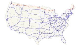
U.S. Route 2 or U.S. Highway 2 (US 2) is an east–west U.S. Highway spanning 2,571 miles (4,138 km) across the northern continental United States. US 2 consists of two segments connected by various roadways in southern Canada. Unlike some routes, which are disconnected into segments because of encroaching Interstate Highways, the two portions of US 2 were designed to be separate in the original 1926 highway plan.
A township in some states of the United States is a small geographic area.

The Canada–United States border, officially known as the International Boundary, is the longest un-militarized international border in the world between two countries. Shared between Canada and the United States, the border belongs to the second- and fourth-largest countries by respective area. The terrestrial boundary is 8,891 kilometres (5,525 mi) long, of which 2,475 kilometres (1,538 mi) is the border between Alaska and Yukon. The agencies currently responsible for facilitating legal passage through the international boundary are the Canada Border Services Agency (CBSA) and U.S. Customs and Border Protection (CBP).

The West River is a tributary of the Connecticut River, about 53.8 miles (86.6 km) long, in southern Vermont in the United States. According to the Geographic Names Information System, it has also been known historically as "Wantastiquet" and as "Waters of the Lonely Way". Its watershed covers 423 square miles (1,100 km2); land use is about 90% forested and 3% agricultural, and the upper river supports wild native brook and wild brown trout, while Atlantic salmon occur in most of the river.

The Ottauquechee River is a 41.4-mile-long (66.6 km) river in eastern Vermont in the United States. It is a tributary of the Connecticut River, which flows to Long Island Sound.
The Ompompanoosuc River is a river, about 25 mi (40 km) long, in eastern Vermont in the United States. It is a tributary of the Connecticut River, which flows to Long Island Sound. According to the Geographic Names Information System, the river has also been known by the names "Om-pom-pa-noos-uc" and "Pompanoosuc."
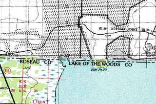
Elm Point, Minnesota, in Lake of the Woods County, Minnesota, is a small uninhabited cape and a United States practical exclave, southwest of the Northwest Angle, near the Indian/First Nation community of Buffalo Point. It borders Canada's province of Manitoba at the 49th parallel and is separated from the rest of the continental United States by Lake of the Woods.

Harvey Lake, locally known as Harvey's Lake, is a lake in the town of Barnet, Vermont in Caledonia County in the northeast section of Vermont, United States. It was named after one of the original settlers of Barnet, Vermont, Colonel Alexander Harvey. Although locally it is known as "Harvey's Lake", it is officially named "Harvey Lake" by the federal Board on Geographic Names, as genitive apostrophes are rarely allowed in the names of natural features.
Wall Lake is an unincorporated community in Otter Tail County, in the U.S. state of Minnesota.
Green Mountain Lake is a lake in Wright County, in the U.S. state of Minnesota.
