New York State Route 3 (NY 3) is a major east–west state highway in New York, in the United States, that connects central New York to the North Country region near the Canada–US border via Adirondack Park. The route extends for 245.88 miles (395.71 km) between its western terminus at an intersection with NY 104A in the Cayuga County town of Sterling and its eastern terminus at a junction with U.S. Route 9 (US 9) in the Clinton County city of Plattsburgh. NY 3 traverses eight counties and is a lakeside roadway from Mexico to Sackets Harbor, a mountainous route in Adirondack Park, and an urban arterial in Fulton, Watertown, and Plattsburgh.
New York State Route 149 (NY 149) is an east–west state highway that runs for 32.20 miles (51.82 km) through the Capital District of New York in the United States. It begins at exit 20 on the Adirondack Northway in the Warren County town of Queensbury and intersects U.S. Route 9 (US 9), US 4, and NY 22, among other routes, as it progresses eastward to its eastern end at the Vermont state line in the Washington County village of Granville. Here, the highway becomes Vermont Route 149 (VT 149) and continues for an additional 1.302 miles (2.095 km) to an intersection with VT 30 in Rutland County. Both NY 149 and VT 149 traverse mostly rural areas.
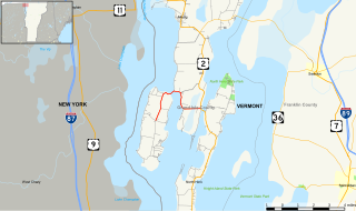
U.S. Route 2 (US 2) is a part of the U.S. Highway System that is split into two segments. Its eastern segment runs from Rouses Point, New York, to Houlton, Maine. In Vermont, US 2 extends 151.604 miles (243.983 km) from the New York state line in Alburgh to the New Hampshire state line in Guildhall. West of Vermont, US 2 continues into New York for another 0.87 miles (1.40 km) to an intersection with US 11 in Rouses Point. US 2 passes through the cities of Burlington and Montpelier as it traverses the state. The Burlington to Montpelier route was first laid out as a toll road in the early 19th century. It was later incorporated into the transcontinental auto trail known as the Theodore Roosevelt International Highway in 1919 before being designated as part of US 2 in 1926.
New York State Route 269 (NY 269) is a north–south state highway located in western New York in the United States. The highway runs for 6.36 miles (10.24 km) along the Niagara–Orleans county line and is named County Line Road. The southern terminus of NY 269 is at an intersection with NY 104 in the hamlet of Jeddo. Its northern terminus is at a junction with NY 18 in the hamlet of County Line. NY 269 is one of only two state highways in New York that are located wholly along a county boundary; the other is NY 272 on the other side of Orleans County. The route was assigned as part of the 1930 renumbering of state highways in New York and has not been altered since.
New York State Route 8 (NY 8) is a 207.45-mile-long (333.86 km) north-south state highway in the central part of New York in the United States. It runs in a southwest-to-northeast direction from the Southern Tier to the northern part of Lake George. The southern terminus of the route is at an interchange with NY 17, where it begins concurrent with NY 10 in the town of Deposit. Its northern terminus is at a junction with NY 9N in the town of Hague. Roughly midway between the two endpoints, NY 8 passes through Utica, where it overlaps NY 5, NY 12, and Interstate 790 (I-790) along one segment of the North–South Arterial.
New York State Route 346 (NY 346) and Vermont Route 346 (VT 346) are short, adjoining state highways in the northeastern United States. Together, they extend for a combined 7.25 miles (11.67 km) through the towns of Petersburgh in Rensselaer County, New York, and Pownal in Bennington County, Vermont. The bi-state highway begins at an intersection with NY 22 in the hamlet of North Petersburgh and heads generally southeastward across the New York–Vermont state line to a junction with U.S. Route 7 (US 7) in the village of Pownal. Both NY 346 and VT 346 parallel the Hoosick River.
New York State Route 22A (NY 22A) is a short north–south state highway located within Washington County, New York, in the United States. The route extends for 10.6 miles (17.1 km) from an intersection with NY 22 in the town of Granville to the Vermont state line in the town of Hampton, where it becomes Vermont Route 22A (VT 22A). NY 22A was originally designated as New York State Route 286 in the 1930 renumbering of state highways in New York. It was renumbered to its current designation in the early 1940s.
New York State Route 247 (NY 247) is a north–south state highway located in the Finger Lakes region of New York in the United States. It extends for 11.08 miles (17.83 km) from an intersection with NY 364 in the Yates County town of Potter to a junction with U.S. Route 20 (US 20) and NY 5 in the Ontario County town of Hopewell. In between, NY 247 serves the village of Rushville and it overlaps with NY 245 for 1.5 miles (2.4 km) from Rushville to Gorham. NY 247 was originally assigned to modern NY 53 from Prattsburgh to Naples in the 1930 renumbering of state highways in New York. At the same time, what is now NY 247 became part of NY 53. The alignments of the two routes were mostly swapped north of Prattsburgh in the early 1940s, placing NY 247 on its current alignment.
New York State Route 74 (NY 74) and Vermont Route 74 (VT 74) are state highways in the northeastern United States, connected by one of the last remaining cable ferries in North America. Together they extend for 34 miles (55 km) through Essex County, New York, and Addison County, Vermont. NY 74 begins at exit 28 off Interstate 87 (I-87) in the hamlet of Severance in the Adirondack Mountains region of the northern part of New York State. It extends 20.44 miles (32.89 km) to the western shore of Lake Champlain in Ticonderoga. There, the seasonal Fort Ticonderoga–Larrabees Point Ferry carries cars across the state border into Vermont, where VT 74 starts at the lake's eastern shore and terminates 13.26 miles (21.34 km) later at a junction with VT 30 in the town of Cornwall.
Vermont Route 17 (VT 17) is a 40.409-mile-long (65.032 km) state highway in western Vermont in the United States. The western terminus of the route is at the New York state line in Addison, where it connects to New York State Route 185 (NY 185) by way of the Lake Champlain Bridge. Its eastern terminus is at a junction with VT 100 in Waitsfield. VT 17 was initially much shorter than it is today, extending from the Champlain Bridge to Addison upon assignment. It was extended east through the Green Mountains to Waitsfield in 1965.
New York State Route 313 (NY 313) and Vermont Route 313 (VT 313) are a pair of like-numbered state highways in New York and Vermont in the United States, that meet at the state line. NY 313 extends for 8.96 miles (14.42 km) through the Washington County town of Salem from New York State Route 22 (NY 22) in Cambridge. Its Vermont counterpart is a 10.050-mile (16.174 km) connection to U.S. Route 7 (US 7) through the Bennington County town Arlington.
New York State Route 228 (NY 228) is a state highway in Schuyler County, New York, in the United States. It runs for 12.47 miles (20.07 km) in a northeast to southwest direction from an intersection with NY 224 in the village of Odessa to a junction with NY 227 in the hamlet of Perry City within the town of Hector. NY 228 has a short overlap with NY 79 in the Hector community of Mecklenburg. The route was assigned as part of the 1930 renumbering of state highways in New York; however, it initially ended at NY 79 in Mecklenburg, from where NY 79 went north to Perry City. NY 79 was realigned to head west from Mecklenburg in the early 1960s, at which time the NY 228 designation was extended northward over NY 79's former routing.
New York State Route 227 (NY 227) is a state highway in the Finger Lakes region of New York in the United States. The highway extends for 9.84 miles (15.84 km) in a northeast–southwest direction from an intersection with NY 79 south of the hamlet of Reynoldsville in the town of Hector to a junction with NY 96 in the village of Trumansburg. In between, NY 227 intersects NY 228 in Perry City by the east town line of Hector and passes through the town of Ulysses. Part of NY 227 straddles the Schuyler–Tompkins county line.
New York State Route 230 (NY 230) is a state highway in the Finger Lakes region of New York in the United States. NY 230 is an east–west highway between the eastern edge of Steuben County to the interior of adjacent Yates County. The western terminus of NY 230 is the community of Keuka in the town of Wayne on the edge of Keuka Lake at NY 54. The eastern terminus is at its junction with NY 14A in the town of Barrington, west of the village of Dundee.
New York State Route 96A (NY 96A) is a state highway in Seneca County, New York, in the United States. It is a north–south road between Seneca Lake and Cayuga Lake, two of the Finger Lakes. NY 96A is two lanes wide for most of its length, with the exception of the 3-mile (5 km) long four-lane divided highway section at the northern end. The southern terminus of NY 96A is at an intersection with NY 96 in the village of Interlaken. Its northern terminus is at a junction with the conjoined routes of U.S. Route 20 (US 20) and NY 5 in the town of Waterloo just east of the city of Geneva. The junction with NY 5 and US 20 was once a trumpet interchange; however, it was converted into an at-grade intersection in the late 1980s.
New York State Route 314 (NY 314) and Vermont Route 314 (VT 314) are a pair of like-numbered state highways in New York and Vermont in the United States, that are connected by way of the Grand Isle–Plattsburgh Ferry across Lake Champlain and the Thomas MacDonough Highway in Plattsurgh. NY 314 extends for 0.76 miles (1.22 km) through the Clinton County town of Plattsburgh from Interstate 87 (I-87) exit 39 to U.S. Route 9. NY 314 previously continued another 3.95 miles (6.36 km) to the ferry landing on Cumberland Head. Its Vermont counterpart is a 5.493-mile (8.840 km) loop route off of U.S. Route 2 (US 2) through the Grand Isle County towns of South Hero and Grand Isle that connects to the ferry near its midpoint.
New York State Route 191 (NY 191) was a 6.24-mile (10.04 km) long state highway located north of Adirondack Park. The route was maintained and co-designated by the Clinton County highway department as County Route 23 (CR 23) and headed from an intersection with NY 22 in the hamlet of Sciota within the town of Chazy to a junction with U.S. Route 9 (US 9) in the hamlet of Chazy. The route met Interstate 87 west of Chazy hamlet.
U.S. Route 4 (US 4) is a part of the U.S. Highway System that runs from East Greenbush, New York, to Portsmouth, New Hampshire. In the U.S. state of New York, US 4 extends 79.67 miles (128.22 km) from an intersection with US 9 and US 20 in East Greenbush to the Vermont state line northeast of Whitehall. While the remainder of US 4 east of New York is an east–west route, US 4 in New York is signed north–south due to the alignment the route takes through the state. The portion of the route between Waterford and Whitehall is part of the Lakes to Locks Passage, an All-American Road.
Vermont Route 129 (VT 129) is a short, 5.415-mile-long (8.715 km) connector route for Isle La Motte and Alburgh in the state of Vermont in the United States. VT 129 begins at an intersection in the centre of Isle La Motte, heads northward and terminates at an intersection with U.S. Route 2 in Alburgh. The route originated as Vermont Route F-2 in 1926, and was the name of the road that approached a ferry to Chazy. Route F-2 followed the same routing as the current VT 129, to which it was renumbered in 1944.
New York State Route 185 (NY 185) is an east–west state highway in Essex County, New York, in the United States. It serves as a connector between NY 9N and NY 22 in Crown Point and the Lake Champlain Bridge, by which the highway enters Vermont and becomes Vermont Route 17 (VT 17). NY 185, named Bridge Road, passes through Crown Point State Historic Site and runs the entire length of Crown Point, a peninsula protruding into Lake Champlain.


