
Leidschendam-Voorburg is a municipality in the western Netherlands, located in the province of South Holland. It had a population of 75,425 in 2019, and covers an area of 35.62 km2 (13.75 sq mi) of which 3.07 km2 (1.19 sq mi) is water.

Bronkhorst is a village in the municipality of Bronckhorst, Gelderland, the Netherlands. Technically, it is a city and with only 157 inhabitants (2010), it is one of the smallest cities in the Netherlands.

Voorburg is a town and former municipality in the west part of the province of South Holland, Netherlands. Together with Leidschendam and Stompwijk, it makes up the municipality Leidschendam-Voorburg. It has a population of about 39,000 people. It is considered to be the oldest city in The Netherlands and celebrated its 2000th year of existence in 1988. However in Holland the status of 'city' normally commenced with the bestowing of a 'city charter' by a its sovereign leader(s) and none is available that old. Human occupation has certainly been established as occurring two millennia ago, where Voorburg is located now. In 2002, the cities of Leidschendam and Voorburg were merged under the new municipality named "Leidschendam-Voorburg". Situated adjacent to the city of The Hague, it is often regarded as one of its suburbs.

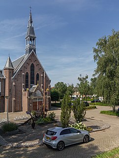
Leidschendam is a town and former municipality in the province of South Holland of the Netherlands. Along with Voorburg and Stompwijk, it is part of the municipality Leidschendam-Voorburg.
Rhoon is a village that borders the municipality of the city of Rotterdam, South Holland, the Netherlands.

Lunteren is a town in Gelderland, the Netherlands. It has a railway station on the line between Amersfoort and Ede.
Pijnacker is a town and suburb in the Dutch province of South Holland. It is bordered Zoetermeer to the north, by Nootdorp to the northwest, by Delfgauw to the southwest, by Rotterdam to the south and by Berkel en Rodenrijs to the east.

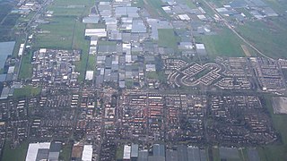
Leidschenveen-Ypenburg is a Vinex-location and district of The Hague, located in the southeast. It is geographically connected to the main body of the city by only a narrow corridor. It consists of four quarters: Hoornwijk and Ypenburg on the southwest of the A12 motorway and parallel railway to Utrecht, and Forepark and Leidschenveen on the northeast.
Barwoutswaarder is a village in the municipality of Woerden in the Netherlands. It is located to the west of the city of Woerden.
Oudenrijn is a hamlet in the Dutch province of Utrecht. It is located in the municipality of Utrecht, in the western part of the city, surrounded by the new neighbourhoods of Leidsche Rijn.

Veessen is a village in the Dutch province of Gelderland. It is located in the municipality of Heerde.

Hogeveen is a hamlet in the Dutch province of South Holland. It is located in the municipality of Alphen aan den Rijn, about 2 km south of Hazerswoude-Dorp.

Stompwijk is a village in the Dutch province of South Holland. It is located between the cities Leiden and Zoetermeer and is part of the municipality of Leidschendam-Voorburg.

Castildelgado is a municipality and town located in the province of Burgos, Castile and León, Spain. According to the 2004 census (INE), the municipality has a population of 70 inhabitants.

Mezalocha is a municipality in province of Zaragoza, Aragon, Spain. According to the 2004 census (INE), the municipality has a population of 285 inhabitants.

Finsterwolde is a village in the Dutch province of Groningen, about 7 km northeast of the city of Winschoten. Finsterwolde was a separate municipality until 1990, when it was merged with Beerta into Reiderland. In 2010 Reiderland merged into the municipality Oldambt. The old municipality of Finsterwolde included six small nearby or connecting settlements. These are also taken into account in the population estimate of 2008, without which the actual population, purely based on the centre and new developments, would be 1250. The village is known for the Galery Waalkens.
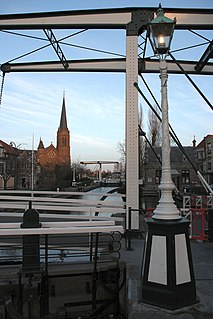
The Vliet is a canal in the western Netherlands, in the province of South Holland. It starts at the Oude Rijn at Leiden and joins the Delfshavense Schie canal at Delft. Places along its banks include Voorschoten, Leidschendam, Voorburg, The Hague and Rijswijk.
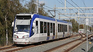
The Hague Tram is a tram network forming part of the public transport system in and around the city of The Hague in South Holland, the Netherlands.

Forepark is a business park in The Hague, Netherlands, east of the Prins Clausplein highway interchange. It was developed in the 1990s, together with the nearby residential neighbourhood Leidschenveen. Originally part of the municipality of Leidschendam, it was annexed by The Hague in 2002 and now falls under the district of Leidschenveen-Ypenburg. Since 2007, Forepark is home to Cars Jeans Stadion, the home stadium of ADO Den Haag. Since the construction of the RandstadRail network, the business park is connected to the metro line between Rotterdam and the city centre of The Hague via Forepark Station.
