Veur-Lent is the name of an island in the Dutch river Waal. It is part of the municipality of Nijmegen, situated in the Lent Quarter, north of both the city center and the main channel of the Waal.
Owing to the threat of dike breaches at high water, it was decided in 1995 that more water would need to flow through the river. Because the sharp bend in the Waal at Nijmegen created a bottleneck and restricted the water flow, a three kilometer long parallel gully, called the Spiegelwaal, was dug at this point.[1][2] This resulted in the creation of the new island.
These activities were started in 2011 and as a result, the water level was lowered by 30 centimeters.[3]
Various bridges were built to the island. The island can be reached by foot from the Waalbrug (Waal Bridge), Spoorbrug (Railway Bridge), the Oversteek, the Zaligebrug (Zalige Bridge) and the Lentloper. The latter was built at a later point from the side of Lent.
There are plans to build homes and shops on the island in the future. The costs of constructing the island amounted to 350 million euros.
Nijmegen is the largest city in the Dutch province of Gelderland and the tenth largest of the Netherlands as a whole. Located on the Waal River close to the German border, Nijmegen is one of the oldest cities in the Netherlands and the first to be recognized as such in Roman times. In 2005, it celebrated 2,000 years of existence.
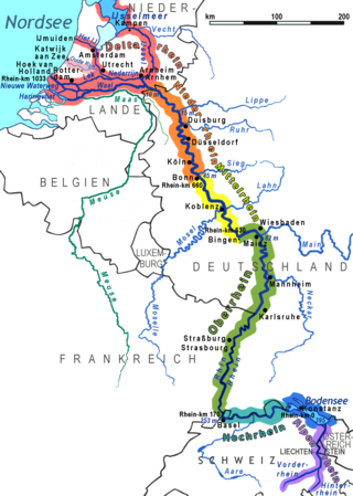
The Rhine is one of the major European rivers. The river begins in the Swiss canton of Graubünden in the southeastern Swiss Alps. It forms part of the Swiss-Liechtenstein, Swiss-Austrian, and Swiss-German borders. After that the Rhine defines much of the Franco-German border, after which it flows in a mostly northerly direction through the German Rhineland. Finally in Germany, the Rhine turns into a predominantly westerly direction and flows into the Netherlands where it eventually empties into the North Sea. It drains an area of 9,973 sq km and its name derives from the Celtic Rēnos. There are also two German states named after the river, North Rhine-Westphalia and Rhineland-Palatinate.
Operation Market Garden was an Allied military operation during the Second World War fought in the German-occupied Netherlands from 17 to 27 September 1944. Its objective was to create a 64 mi (103 km) salient into German territory with a bridgehead over the Nederrijn, creating an Allied invasion route into northern Germany. This was to be achieved by two sub-operations: seizing nine bridges with combined US and British airborne forces (Market) followed by British land forces swiftly following over the bridges (Garden).
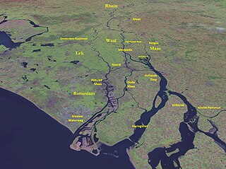
The Waal is the main distributary branch of the river Rhine flowing approximately 80 km (50 mi) through the Netherlands. It is the major waterway connecting the port of Rotterdam to Germany. Before it reaches Rotterdam, it joins with the Afgedamde Maas near Woudrichem to form the Boven Merwede. Along its length, Nijmegen, Tiel, Zaltbommel and Gorinchem are towns of importance with direct access to the river.
Gelderland, also known as Guelders in English, is a province of the Netherlands, occupying the centre-east of the country. With a total area of 5,136 km2 (1,983 sq mi) of which 173 km2 (67 sq mi) is water, it is the largest province of the Netherlands by land area, and second by total area. Gelderland shares borders with six other provinces and the German state of North Rhine-Westphalia.
The Linge is a river in the Betuwe that is 99.8 km long, which makes it one of the longest rivers that flow entirely within the Netherlands.
The Bijlands Kanaal is a canal in the Dutch province of Gelderland, near the Dutch-German border. It is currently by far the most important river-stretch of the Rhine when that major river enters the Netherlands.
Elst is a town in the municipality of Overbetuwe in the Dutch province of Gelderland. It is situated in the Betuwe, between the cities of Arnhem and Nijmegen. In January 2022 the town had 22,509 inhabitants.
The Lower Rhine flows from Bonn, Germany, to the North Sea at Hook of Holland, Netherlands ; alternatively, Lower Rhine may refer to the part upstream of Pannerdens Kop, excluding the Nederrijn.
The Merwede is the name of several connected stretches of river in the Netherlands, between the cities of Woudrichem, Dordrecht and Papendrecht. The river is part of the Rhine–Meuse–Scheldt delta and is mostly fed by the river Rhine.
Jan Jozef Lambert van Hoof was a member of the Dutch resistance in World War II, who cooperated with Allied Forces during Operation Market Garden. He is credited with disabling explosives placed by the Germans to destroy a vital bridge to delay allied liberation, and was later executed in action. Before and during the war, Van Hoof was a Rover Scout, and the Scouting medal the Nationale Padvindersraad was named in his honour.
The Rhine–Meuse–Scheldt delta is a river delta in the Netherlands formed by the confluence of the Rhine, the Meuse and the Scheldt rivers. In some cases, the Scheldt delta is considered a separate delta to the Rhine–Meuse delta. The result is a multitude of islands, branches and branch names, in which a waterway that appears to be one continuous stream may have numerous separate names for different sections, e.g. Rhine → Bijlands Kanaal → Pannerdens Kanaal → Nederrijn → Lek → Nieuwe Maas → Het Scheur → Nieuwe Waterweg. Since the Rhine contributes most of the water, the term "Rhine Delta" is commonly used, although this name is also used for the delta where the Alpine Rhine flows into Lake Constance. By some calculations, the Rhine–Meuse–Scheldt delta covers 25,347 km2 (9,787 sq mi), making it the largest in Europe.
The Nijmegen railway bridge is a truss bridge spanning the River Waal, connecting the city of Nijmegen to the town of Lent in the Netherlands.
The Maas–Waal Canal is a canal in the Netherlands that connects the river Meuse to the river Waal. The channel is about 13.5 kilometres (8.4 mi) long and runs from Weurt to the south and ends at Heumen. The connection of the Meuse and the Maas–Waal Canal is the tripoint between the provinces of Gelderland, Limburg and North Brabant.
The IJssel Line was the Dutch portion of the NATO Cold War line of defence for Western Europe during the 1950s and 1960s. It consisted of anti-aircraft and four-barrel machine gun bunkers, command and hospital bunkers, and many Ram and Sherman tank bunkers encased in concrete, leaving the turrets exposed. These elements were placed along the IJssel river.
The Stratemakerstoren is an early 16th-century bastion on the Waalkade in the Dutch town Nijmegen. It is a rijksmonument and since 1995, it housed a museum. This was closed in April 2015, for major reconstruction. The Stratemakerstoren is located on the edge of the river Waal, at the foot of the Valkhof at Nijmegen. This bastion was a part of the fortifications of Nijmegen, built in or before 1526. The current name, which means "Road Workers Tower", was already in use in 1569 - the reason for this name is still not exactly known.
Schenkenschanz is a small community in North Rhine-Westphalia, Germany that was incorporated into the town of Kleve (Cleves) in 1969. Schenkenschanz is site of the former Schenkenschans fortress that was of significance in the Dutch Revolt.
The Battle of Nijmegen, also known as the Liberation of Nijmegen, occurred from 17 to 20 September 1944, as part of Operation Market Garden during World War II.
The siege of Nijmegen occurred from 27 October to 8 November 1794 during the Flanders campaign of the War of the First Coalition. It was the last major military confrontation between the forces of the Revolutionary French First Republic and the reactionary First Coalition of European monarchs including William V, Prince of Orange, before the fall of the Dutch Republic in January 1795, which William had ruled as hereditary stadtholder since 1751. As commander-in-chief of the Dutch States Army, his indecision, several changes of mind and lack of coordination with his Anglo-Hanoverian, Hessian, Prussian and Austrian allies contributed to the eventual surrender of Nijmegen to the French revolutionaries.
This page is based on this Wikipedia article Text is available under the CC BY-SA 4.0 license; additional terms may apply. Images, videos and audio are available under their respective licenses.