
Toodyay, known as Newcastle between 1860 and 1910, is a town on the Avon River in the Wheatbelt region of Western Australia, 85 kilometres (53 mi) north-east of Perth. The first European settlement occurred in the area in 1836. After flooding in the 1850s, the townsite was moved to its current location in the 1860s. It is connected by railway and road to Perth. During the 1860s, it was home to bushranger Moondyne Joe.
Bailup is a Western Australian locality and rural residential estate located 62 kilometres (39 mi) northeast of the state capital, Perth, along Toodyay Road. The population recorded at the 2021 census was 54. The area is split between the Shire of Toodyay and Shire of Mundaring, the latter of which contains most of the Bailup area.
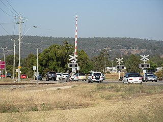
Toodyay Road is a mostly 2-lane undivided single carriageway in Western Australia, running from the north-eastern Perth suburb of Middle Swan, through Gidgegannup and Bailup, to the Wheatbelt town of Toodyay. It is signposted as State Route 50.
The Shire of Toodyay is a local government area in the Wheatbelt region of Western Australia, beyond the north-eastern limits of the Perth metropolitan area. The Shire covers an area of 1,694 square kilometres (654 sq mi), and its seat of government is the town of Toodyay.

Stirling House is located on Stirling Terrace in Toodyay, Western Australia.

Whitfield House is located on Fiennes Street in Toodyay, Western Australia.

Toodyay Manor on Stirling Terrace was originally the Newcastle Hotel in Toodyay, Western Australia.

Urwin's Store is a historically significant building located on Stirling Terrace in Toodyay, Western Australia. It is registered on the Australian Heritage Database.

Toodyay Fire Station is on Stirling Terrace in Toodyay, Western Australia.

The Victoria Hotel is located on Stirling Terrace in Toodyay, Western Australia. It was classified by the National Trust of Australia in 1977 and added to the Register of National Estates in 1980.

Stirling Terrace is the main street of Toodyay, Western Australia, originally called New Road until 1905.

The Stationmaster's House on Stirling Terrace, Toodyay, Western Australia was built in 1895.

Dr Growse's House is located on Stirling Terrace in Toodyay, Western Australia and was constructed in the early 1860s, possibly with convict labour.

Freemasons Hotel, now Toodyay Hotel, is a historic building on Stirling Terrace in Toodyay, Western Australia. It was built for William Tregoning, and originally licensed in 1861 as the Newcastle Hotel. The building was classified by the National Trust, and is listed on both the Register of the National Estate and the Australian Heritage Database.

West Toodyay was the original location of the town of Toodyay, Western Australia. It is situated in the Toodyay valley, 85 kilometres (53 mi) north east of Perth. The Toodyay valley, discovered by Ensign Robert Dale in 1831, was opened up for settlement in 1836. The original site for the town of Toodyay was determined in 1836 and its boundaries were finalized 1838. The first survey of the town was carried out in 1849. After several serious floods, the decision was made to move the town of Toodyay to higher ground. In 1860, the new town of Newcastle was established 3 miles (4.8 km) further upstream. Newcastle was renamed in 1910 to Toodyay, and the original site became known as West Toodyay.

The Toodyay Barracks and its stables, erected in 1842, were the first buildings constructed in the townsite of Toodyay, Western Australia. The Barracks were also the first government buildings within the Toodyay district. Situated on the left bank of the Avon River and a little upstream from the ford, the Barracks overlooked a long pool, which soon became known as the Barracks Pool. In the early 1840s, Toodyay Resident Magistrate John Scully had requested military protection as a means of controlling a problem with the local indigenous people. Governor John Hutt agreed at the time to temporarily station a mounted native policeman to keep order.
An area in West Toodyay, Western Australia, was gazetted as a Class C Reserve, for water and public utility purposes from 1898 to 1992. A stone-lined well at 31.52281°S 116.42579°E, positioned on what was originally lot R76, exists to this today. It is, however, no longer in use. The well is close to the boundary with what was originally lot R1 on which a spring once arose and flowed into the Avon River. It is very likely that the well had supplied water for a long time, possibly during the 1850s, the days of the convict hiring depot and The Queen's Head hotel.

The West Toodyay School, originally named the Toodyay School, was a government school in West Toodyay in Western Australia. It opened on 6 February 1899 as a replacement for the original Toodyay Valley government school, which had been closed on 23 October 1898. The new Toodyay School was situated near the left bank of the Avon River on what was previously known as Toodyay suburban lot 30. It was within easy distance of what became the site of the West Toodyay Bridge.

Everett's Cottage is the only remaining building from the original township of old Toodyay, now known as West Toodyay, in Western Australia. Situated in North Street on the three-acre allotment of Suburban Lot 1, it stands immediately behind the site of the former Queen's Head Hotel. Suburban Lot 1 was registered to James Everett on 3 July 1860.
Drummond's Rose Hedge is an historic planting of rose bushes along the Bindi Bindi-Toodyay Road about five kilometres north of the town of Toodyay, Western Australia. It was planted in about 1860 by the botanist and farmer James Drummond near the homestead of his estate Hawthornden.

