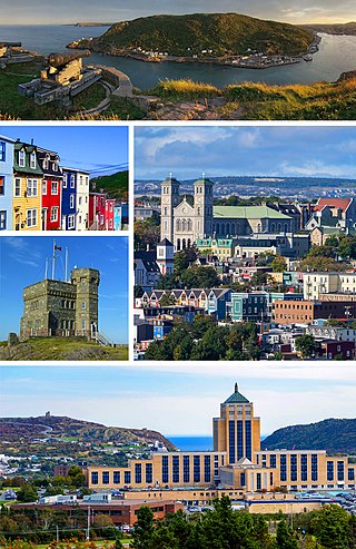
St. John's is the capital and largest city of the Canadian province of Newfoundland and Labrador. It is located on the eastern tip of the Avalon Peninsula on the island of Newfoundland. The city spans 446.04 km2 (172.22 sq mi) and is the easternmost city in North America.

Canada has a large domestic and foreign tourism industry. The second largest country in the world, Canada's incredible geographical variety is a significant tourist attractor. Much of the country's tourism is centred in the following regions: Toronto, Montreal, Quebec City, Vancouver/Whistler, Niagara Falls, Vancouver Island, Canadian Rockies, British Columbia's Okanagan Valley, Churchill, Manitoba and the National Capital Region of Ottawa-Gatineau. The large cities are known for their culture, diversity, as well as the many national parks and historic sites.
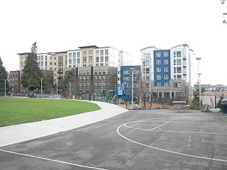
Cascade is an urban neighborhood abutting Downtown Seattle, Washington, United States, located adjacent to South Lake Union. It is bounded by: Fairview Avenue North on the west, beyond which is the rest of the Cascade Neighborhood; the Interstate 5 interchange for Mercer St to the north, beyond which is Eastlake; Interstate 5 on the east, beyond which is Capitol Hill; and Denny Way on the south, beyond which is Denny Triangle. It is surrounded by thoroughfares Mercer Street (eastbound), Fairview Avenue N. and Eastlake Avenue E., and Denny Way. The neighborhood, one of Seattle's oldest, originally extended much further: west to Terry Avenue, south to Denny Hill on the South, and east to Melrose Avenue E through the area now obliterated by Interstate 5. Some recent writers consider Cascade to omit the northern "arm", while others extend it westward to cover most of South Lake Union.

Victoria Park is centrally located in the city of Hamilton, Bermuda. It is a public park that is opened daily to the public during daylight hours. It is widely used as an entertainment venue for free concerts and the like. There is also a rather attractive bandstand in the middle of the park, installed in 1889 in commemoration of the Golden Jubilee of Queen Victoria, and renewed in 2008. The park also contains attractive flower gardens and several species of endemic plants and trees. The park takes up a full block, with a number of benches and public restrooms. The park is bordered by Victoria Street, Washington Street, Dundonald Street and Cedar Avenue. It is under the administration of the Corporation of Hamilton.

The High School of Glasgow is a private, co-educational day school in Glasgow, Scotland. The original High School of Glasgow was founded as the choir school of Glasgow Cathedral in around 1124, and is the oldest school in Scotland, and the twelfth oldest in the United Kingdom. On its closure as a selective grammar school by Glasgow City Corporation in 1976, it immediately continued as a co-educational independent school as a result of fundraising activity by its Former Pupil Club and via a merge by the Club with Drewsteignton School. The school maintains a relationship with the Cathedral, where it holds an annual service of commemoration and thanksgiving in September. It counts two British Prime Ministers, two Lords President and the founder of the University of Aberdeen among its alumni.
Paul O'Neill was a writer, historian and former CBC producer. He wrote many books on the history of Newfoundland. O'Neill was born in St. John's, Newfoundland, and raised in Bay de Verde until the age of 8 when his family moved to St. John's.

Johnny Burke (1851–1930) was a Newfoundland poet, singer, songwriter, and musician from St. John's, where he lived all his life. He was nicknamed the Bard of Prescott Street and wrote many popular songs that were released by folk singers in the 1930s and 1940s.

Pleasant Hill is a neighbourhood of Saskatoon, Saskatchewan, Canada. The Governments are undertaking a major re-vitalization project of Pleasant Hill. $3.5 million is being invested in the business, and residential areas as well as in St. Mary's School. Together the Saskatoon Urban Renewal Project, the provincial government and the Western Economic Diversification project of the federal Government will result in neighbourhood overhauls. 29 lots zoned for business along 20th Street will be levelled and modern commercial upgrades put into place. Selected lots along Avenue N and Avenue O zoned as residential will be demolished to make way for affordable and decent homes. St. Mary's School will receive major renovations or replacement, possibly even a new community centre.

Richmond Heights, adjacent to the South Saskatchewan River, features walking trails in the Meewasin Valley. G.D. Archibald Park North hosts baseball and soccer games. Luther Heights is a Luther care community for those aged 60 and over. In 2006, 73.5% of the residents owned their own home; the average home size was 2.3 residents.

Cannon Street is a Lower City collector road in Hamilton, Ontario, Canada. It starts off at Queen Street North as a one-way street (Westbound) up to Sherman Avenue North where it then switches over to a two-way street the rest of the way Eastward and ends just past Kenilworth Avenue North on Barons Avenue and merges with Britannia Avenue, a street that runs parallel with Cannon Street from Ottawa Street North to Barons Avenue.

This is a list of neighbourhoods in the urban core of Greater Sudbury, Ontario. This list includes only those neighbourhoods that fall within the pre-2001 city limits of Sudbury — for communities within the former suburban municipalities, see the articles Capreol, Nickel Centre, Onaping Falls, Rayside-Balfour, Valley East and Walden.
Bannerman Park is a Victorian era urban park located in St. John's, Newfoundland and Labrador. The park is named for Sir Alexander Bannerman, Governor of the Colony of Newfoundland from 1857 to 1864, who assented to an Act establishing the park and donated land for the purpose in 1864. The park occupies the city block bounded by Bannerman Road, Military Road, Rennie's Mill Road, and Circular Road excluding several residential lots carved out of the southwest corner.
Bannerman is a residential neighbourhood in the Clareview area of north east Edmonton, Alberta, Canada. It is named after "H. Bannerman, who settled in the Belmont area in 1883."
John Callis was a 16th-century Welsh pirate. He was active in South Wales from Cardiff to Haverfordwest, often selling his prizes and cargo in the villages of Laugharne and Carew in Milford Haven, only a few miles south of Little Newcastle, Wales. His piratical career lasted for decades before pressure from neighbouring countries forced the government of England to take action and managed to capture him in 1576.
The architecture of St. John's, in Newfoundland and Labrador, Canada, has a style distinct from that of the rest of Canada, and its major buildings are remnants of its history and prestige as the first British colonial capital. The city of St. John's has had a long history, with inhabitation dating to the 16th century onwards. As the city grew, so, too, did the landscape. Buildings took a variety of styles according to the styles and means available to build the structures. Starting as a fishing outpost for European fishermen, St. John's consisted mostly of the homes of fishermen, sheds, storage shacks, and wharves. Of course, these structures were small and constructed out of wood. Like many other cities of the time, as the Industrial Revolution took hold and new methods and materials for construction were introduced, the landscape changed as the city grew in width and height. The Great Fire of 1892 destroyed most of the downtown core, and most residential and other wood-frame buildings date from this period. Often compared to San Francisco because of its hilly terrain and steep maze of residential streets, housing in St. John's is typically painted in bright colours, unlike most other parts of Canada.

The Salvation Army in Canada is the Canadian territory of a Christian church that is known for its charity work, with a motto of Giving Hope Today. The Salvation Army was formed in 1865 in London, England, and it began working in Canada in 1882. Today, it operates in 400 communities across Canada and in Bermuda. The Salvation Army Archives are in Toronto, and the Salvation Army's Training College is in Winnipeg.

Betsy Head Park is a 10.55-acre (4.27 ha) public park in the Brownsville neighborhood of Brooklyn in New York City. The park occupies two non-contiguous plots diagonally across from each other at the intersection of Dumont Avenue and Thomas S. Boyland Street, covering a collective 10.55 acres (4.27 ha). The modern-day park contains a playground, a swimming complex, and fields for baseball, football, tennis, and basketball. The park's swimming complex, the Betsy Head Play Center, was designed by Ely Jacques Kahn and consists of a bathhouse, a general swimming pool, and an infilled diving pool. The park is operated by the New York City Department of Parks and Recreation, also known as NYC Parks.
