
Papanui is a major suburb of Christchurch, New Zealand. It is situated five kilometres to the northwest of the city centre. Papanui has a population of 3,645 consisting predominantly of Pākehā 86.9%, Asian 7.6%, Māori 5.3%, Pacific peoples 3.1%, Middle Eastern/Latin American/African 0.7%. The suburb is located at the junction of three busy thoroughfares; Papanui Road leading to the city, the Main North Road that leads to North Canterbury and Harewood Road that leads to Christchurch International Airport. However, as with most Christchurch suburbs, Papanui has no defined borders.

Bryndwr is a suburb in the north-west of Christchurch, New Zealand.
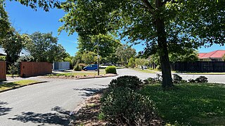
Redwood is a northern suburb of Christchurch, New Zealand which includes the sub-division of Redwood Springs. It is bordered by the Styx River to the north.

St Albans is a large, inner-northern suburb of Christchurch, New Zealand, located directly north of the Christchurch Central Business District. It is the second largest suburb in the city by population, with a population of 13,137 at the 2018 Census. The suburb falls within the Christchurch Central electorate and is represented by Duncan Webb, who has been the member of parliament since the 2017 general election. St Albans is one of the most diverse residential neighbourhoods in Christchurch, with a wide range of densities, architectural styles and housing ages throughout the suburb. It has everything from run-down high-density council-owned flats, to modern luxurious high-density flats and apartments; old mid-density workers cottages through to large low-density estates of various ages.

The Christchurch Convention Centre was New Zealand's only purpose-built convention centre, in Christchurch, the South Island's largest city. It was opened by the mayor of Christchurch, Vicki Buck, in November 1997, and was demolished in early 2012 following the 2011 Christchurch earthquake.

The Christchurch Town Hall, since 2007 formally known as the Christchurch Town Hall of the Performing Arts, opened in 1972, is Christchurch, New Zealand's premier performing arts centre. It is located in the central city on the banks of the Avon River overlooking Victoria Square, opposite the former location of the demolished Christchurch Convention Centre. Due to significant damage sustained during the February 2011 Christchurch earthquake, it was closed until 2019. Council staff initially recommended demolition of all but the main auditorium, but at a meeting in November 2012, councillors voted to rebuild the entire hall. In 2020, the town hall was registered as a Category I heritage building.

Merivale is a suburb of Christchurch, New Zealand, north of the city centre. Like all suburbs in Christchurch, it has no defined boundaries and is a general area, but for the purposes of statistical analysis only, Statistics New Zealand defines it as being Heaton Street to the north, Papanui Road to the east, Harper and Bealey Avenues to the south and Rossall Street to the west, although Real Estate advertising often will claim residences outside this area, especially St Albans to the east of Papanui Road, as being Merivale due to the perceived desirability of the area. The area directly west of Rossall Street, which is called Holmwood by Statistics New Zealand, is sometimes considered part of Merivale.

The Christchurch tramway system was an extensive network in Christchurch, New Zealand, with steam and horse trams from 1882. Electric trams ran from 1905 to 1954, when the last line from Cashmere to Papanui was replaced by buses.
Strowan is an affluent suburb of Christchurch, New Zealand, located approximately 5 km north-west of Christchurch's central business district. It had a population of 3,705 at the 2013 census. It is located between the suburbs of Merivale, Papanui, Bryndwr, Fendalton, and St Albans.

Christchurch Central City or Christchurch City Centre is the geographical centre and the heart of Christchurch, New Zealand. It is defined as the area within the Four Avenues and thus includes the densely built up central city, some less dense surrounding areas of residential, educational and industrial usage, and green space including Hagley Park, the Christchurch Botanic Gardens and the Barbadoes Street Cemetery.
Christchurch tramway routes have developed from lines that were first established by a troika of private tramway companies in the latter part of the 19th century, through to a significantly expanded system under the municipal Christchurch Tramway Board, to the City Council-built heritage circuit. These routes have been worked by all three main forms of tramway motive power and have significantly contributed to the development of Christchurch City in New Zealand's South Island.

Colombo Street is a main road of the city of Christchurch, New Zealand. It runs south-north through the centre of Christchurch with a break at Cathedral Square. As with many other central Christchurch streets, it is named for a colonial Anglican bishopric, Colombo, Sri Lanka in what at the time was known as Ceylon. Parts of the street which run through Sydenham were known as Addison Street during the 1880s, and some parts were known as Colombo Road.
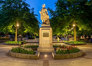
The Cook Statue in Victoria Square, Christchurch, commemorates the three journeys of James Cook to New Zealand. The statue, sculpted by William Trethewey, was unveiled on 10 August 1932 by the Governor-General, Lord Bledisloe. It was donated by bookmaker and philanthropist Matthew Barnett (1861–1935).

Victoria Square is a public park located in central Christchurch, New Zealand. Originally known by European settlers as Market Place or Market Square, it was renamed to Victoria Square in 1903 in honour of Queen Victoria. It was one of the four squares included in the original plan of Christchurch when the city was laid out in 1850.
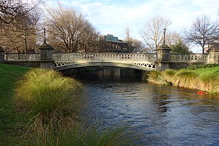
Hamish Hay Bridge is located in Victoria Square, Christchurch, New Zealand. Built in 1864, it was renamed in 1989 for Sir Hamish Hay, Mayor of Christchurch; a commemorative bronze plaque is affixed to the bridge's guard rail in the middle of the structure to honor Hay's services. The bridge, the oldest heritage feature in the square, is also the country's oldest cast iron and stone bridge. It survived the 2011 earthquake undamaged. Architectural features include the bridge arch and the balustrade's neo-gothic ornamentation. The bridge is registered as a Category II heritage structure with the New Zealand Historic Places Trust.

The Crowne Plaza Christchurch, formerly known as the Forsyth Barr Building, is located on the south-east corner of the Armagh and Colombo Streets intersection in Christchurch, New Zealand. Originally owned by Bob Jones and branded Robert Jones House by him, it was commonly referred to as Bob Jones Tower, but some called it Bob's Folly. In the 2011 Christchurch earthquake, its staircases collapsed, trapping the occupants. The building reopened in July 2017 as the city's Crowne Plaza hotel.

The Crowne Plaza in Christchurch, New Zealand, originally known as the Parkroyal Hotel, was a hotel of the Crowne Plaza group. Built in 1988 in the north-west corner of Victoria Square after much public protest, as it cut off the first part of Victoria Street, its construction happened at the same time and enabled the substantial redesign of Victoria Square. The building had New Zealand's largest atrium, and was one of the city's largest hotels. The building suffered significant damage in the 2011 Christchurch earthquake and was demolished in April 2012. The Crowne Plaza group has secured a lease in the Forsyth Barr Building at the opposite end of Victoria Square.
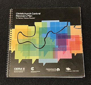
The Christchurch Central Recovery Plan, often referred to as the Blueprint, is the plan developed by the Fifth National Government of New Zealand for the recovery of the Christchurch Central City from a series of earthquakes, in particular the February 2011 Christchurch earthquake. The Canterbury Earthquake Response and Recovery Act 2010 required the Christchurch City Council to develop a recovery plan for the central city. The plan, known as Share an Idea, was presented to the Minister for Canterbury Earthquake Recovery, Gerry Brownlee, in December 2011. Brownlee rejected the city council's plan, established the Canterbury Earthquake Recovery Authority (CERA), and tasked that organisation with developing a plan based on the city council's draft. The Christchurch Central Recovery Plan was published in July 2012 and defined 17 anchor projects. All projects where a timeline was specified were to have been finished by 2017; none of the 17 projects have been delivered on time and some have not even been started yet.

The Four Avenues are a group of four major arterial boulevards — Bealey Avenue, Fitzgerald Avenue, Moorhouse Avenue, and either Rolleston Ave or Deans Avenue — that surround the city centre of Christchurch, New Zealand. Serving as an inner ring road, they popularly form the limits of the city centre, separating it from the city's suburbs. Almost all of the city's commercial heart lies within the approximately rectangular 9.8-square-kilometre (3.8 sq mi) area formed by the four avenues. The term "within the Four Avenues" is widely used in Christchurch to refer to the central city. By extension, Christchurch as a whole is sometimes referred to as "The Four Avenues".

Worcester Street is a road in the central city of Christchurch, New Zealand. It runs from the intersection of Rolleston Avenue in the west, and terminates in the east at the intersection of Woodham Road in Linwood. Between Rolleston Avenue and Cambridge Terrace, it is known as Worcester Boulevard.


