
Mahendra Bir Bikram Shah Dev was King of Nepal from 13 March 1955 until his death in 1972, which was due to a heart attack, as told in an interview by his personal physician Dr. Mrigendra Raj Pandey. Following the 1960 coup d'état, he established the party-less Panchayat system, which governed the country for 28 years until the introduction of multi-party democracy in 1990. During his reign, Nepal experienced a period of industrial, political and economic change which opened it to the rest of the world for the first time, after the 104-year-long reign of the Rana rulers, who kept the country under an isolationist policy, came to an end in 1951.

Chitwan District is one of 77 districts of Nepal, and takes up the southwestern corner of Bagmati Province. Bharatpur, largest city of Nepal after Kathmandu, is its administrative centre. It covers 2,238.39 km2 (864.25 sq mi), and in 2011 had a population of 579,984 people. Bharatpur is the commercial and service centre of South Central Nepal and a major destination for higher education, health care and transportation in the region. Chitwan lies in the Terai region of Nepal. It is in the drainage basin of the Gandaki River and is roughly triangular, taking that river as its meandering northwestern border, and a modest watershed border, with India, as the basis of its southern limit. Local government: Bharatpur Metropolitan, Rapti Municipality, Ratnanagar Municipality, Kalika Municipality, Khairahani Municipality, Madi Municipality, Ikshyakamana Gaupalika
Magar Dhut is a Sino-Tibetan language spoken mainly in Nepal, southern Bhutan, and in Darjeeling, Assam and Sikkim, India, by the Magar people. It is divided into two groups and further dialect divisions give distinct tribal identity. In Nepal 810,000 people speak the language.
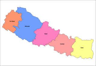
Prior to the promulgation of a new constitution in 2015 after an earthquake, Nepal was divided into five development regions, 14 administrative zones and 75 districts. The 14 administrative zones were grouped into five development regions. Each district is headed by a Chief District Officer (CDO) responsible for maintaining law and order and coordinating the work of field agencies of the various government ministries.

Hariwan or Harion is a town and municipality in Nepal, located in Sarlahi District. The municipality is surrounded by Lalbandi municipality in the East and Bagmati municipality in the West, Hariharpurgadhi municipality of Sindhuli District, Bagmati Province falls in the North and Haripur in the South. It has been divided into 11 wards with an administration center in Harion Bazar.
Mirchaiya formerly known as Ramnagar Mirchaiya is a municipality in Siraha District in the Madhesh Province of south-eastern Nepal. The municipality was established on 18 May 2014 by merging the existing Rampur Birta, Malhaniyakhori, Radhopur, Ramnagar Mirchaiya, Phulbariya, Sitapur PraDa and Maheshpur Gamharia Village Development Committees. At the time of the 2017 municipality records, it had a population of approx. 52,000 people living in approx 8,496 individual households. This is one of the main business markets for Katari and the southern part of the Siraha district. Raw material produced here includes padday, miazem, and sugar cane.

Kumarwarti is a village development committee in Nawalparasi District in the Lumbini Zone of southern Nepal. At the time of the 1991 Nepal census it had a population of 4155 people living in 698 individual households. However data derived more recently for marriage and education details has suggested in 2001 the population had grown to over 5000.
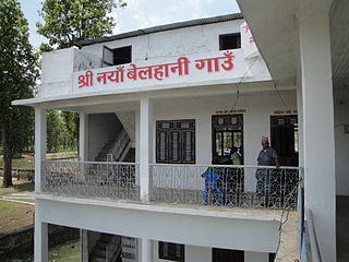
Naya Belhani is a village development committee in Nawalparasi District in the Lumbini Zone of western Nepal. At the time of the 1991 Nepal census it had a population of 9786 people living in 1795 individual households. Naya Belhani is divided into 9 wards, among which ward number 9, Arunkhola is the center of the VDC, which is considered one of an emerging business market of the Nawalparasi district. The VDC's main interesting factor is divided into two parts by Aarungkhola river and East West highway. The river is partition 6, 7 & 9 ward east region and 1,2,3,4,5,8 west region.
Rajahar is a village development committee in Nawalparasi District in the Lumbini Zone of southern Nepal. It lies in and is intersected by Mahendra Highway. Rajahar Bazar is one of the oldest town of the area. This area is highly served by weekly street market every Sunday commonly known as Haat. At the time of the 1991 Nepal census it had a population of 7839 people living in 1387 individual households.

Kawasoti (Nepali: कावासोती) is a municipality in Nawalpur District, Gandaki Province, Nepal. It is 31 km (19 mi) west of Bharatpur and 85 km (53 mi) east of Butwal, approximately on the middle of Mahendra Highway. The Naryani River flows south of it, and the Mahabharat Range is north of it.
Bardaghat नेपाली: बर्दघाट is a Municipality in Nawalparasi District in Lumbini Province, Nepal. It is situated in the lap of the Chure range. This municipality was established on 18 May 2014 by merging existing Makar and Panchanagar Village Development Committees (VDCs). Again during the local election, the neighbouring VDC Dawanne devi and some parts of Dhurkot, Jamuniya, and Rupauliya were merged. It has a population of 76,703 with an area of 162.05 km2. The annual population growth rate is 2.77%. It has a literacy rate of 82.05%. It is an emerging town of Nawalparasi District that is developing rapidly with tourist areas.
Gaindakot is a municipality in Nawalpur District in the Gandaki Zone of southern Nepal. It became a municipality in May 2014 by merging the existing Mukundapur, Amarapuri, and Gaindakot VDCs. It was again expanded by merging Ratanpur VDC. It is situated on the shore of Narayani River near the Maula Kalika Temple. At the 2011 Nepal census it had a population of 58,841 and 13,623 individual households. The population grew to 79,349 with 20,191 individual household according to 2021 Nepal census.
Shahidnagar Danda is the city center in Nawalpur District in Gandaki Province of southern Nepal. It is located in Kawasoti municipality, ward number 16. Shahidnagar Danda is locally known as Danda Bazar. It is the most highly populated areas in Kawasoti municipality after Kawasoti itself and one with a well developed infrastructure.

Daunne Devi Temple is a Hindu temple of Durga located in, Nawalparasi district of Nepal. The temple lies in the hill pass at an elevation of 1033 m msl in route from Bardaghat to Dumkibas. The temple also has Shivalaya due to which the temple is visited by pilgrimages in the month of Shrawan. The temple is believed to be established by Jung Bahadur Rana.

Krishna Chandra Nepali Pokharel, also known as Krishna Chandra Nepali, is a Nepalese politician and Chief Minister of Gandaki Province. He was unanimously selected Parliamentary Party leader of Nepali Congress for Gandaki Province after potential CM candidate Pradip Poudel lost in his constituency with less than 100 vote's margin. Nepali is ex-member of NC central committee.
Bhrikuti Pulp and Paper was a pulp mill and paper mill located in Gaindakot, Nepal.


