
Jondal is a municipality in Hordaland county, Norway. It is located on the Folgefonna peninsula in the Hardanger district, on the eastern shore of the Hardangerfjorden. The administrative centre of the municipality is the village of Jondal. Other villages in Jondal include Herand, Kysnesstranda, and Torsnes.

Ullensvang is a municipality in Hordaland county, Norway. It is located in the traditional district of Hardanger. The administrative centre is the village of Kinsarvik. Other villages in the municipality include Lofthus, Utne, Vikebygd, and Alsåker.

Samnanger is a municipality in the Midhordland region of Hordaland county, Norway. The administrative centre of the municipality is the village of Tysse. Other main villages in the municipality include Haga and Bjørkheim in Nordbygda. The municipality is located about 20 kilometres (12 mi) east of the city of Bergen, Norway's second largest city. It surrounds the inner part of the Samnangerfjorden and the surrounding valleys. There are mountains that surround the municipality. The development of hydroelectric power plants started here in 1909.

Ågotnes is a village in Fjell municipality in Hordaland county, Norway. The industrial village is located on northern part of the island of Store Sotra, about 20 kilometres (12 mi) west of the city of Bergen. The village of Landro lies about 3 kilometres (1.9 mi) to the northwest. Ågotnes serves as a commercial centre for the northern part of Sotra. It is the site of a primary school, sports facilities, fire station, and health clinic. It is also a main supply base for the oil industry.

Norheimsund is the administrative centre of the municipality of Kvam in Hordaland county, Norway. The village is located on the northern side of the Hardangerfjord, about 80 kilometres (50 mi) from the city of Bergen. The village of Øystese lies about 4 kilometres (2.5 mi) to the northeast and the village of Vikøy lies about 3 kilometres (1.9 mi) southeast of Norheimsund. The village of Steine is a suburb, immediately to the west of Norheimsund. The 2.5-square-kilometre (620-acre) village has a population (2012) of 2,224; giving the village a population density of 890 inhabitants per square kilometre (2,300/sq mi), the largest settlement in the whole municipality.
Øystese is a village in the municipality of Kvam in Hordaland county, Norway. It is located along the Hardangerfjord about 7 kilometres (4.3 mi) east of the municipal centre of Norheimsund. Norwegian County Road 7 passes through the village. The 1.89-square-kilometre (470-acre) village has a population (2012) of 1,881; giving the village a population density of 995 inhabitants per square kilometre (2,580/sq mi).

Røldal is a village in the municipality of Odda in Hordaland county, Norway. The village lies in the Røldal valley along the Storelva river on the north end of the lake Røldalsvatnet. Røldal is located about 35 kilometres (22 mi) southeast of the town of Odda. Røldal was formerly part of the independent municipality of Røldal from 1838 until 1964 when it became a part of Odda municipality. The 13th-century Røldal Stave Church is located here.
Bjølsegrøvvatnet is a lake in the municipality of Kvam in Hordaland county, Norway. The 5.82-square-kilometre (2.25 sq mi) lake lies at an altitude of 880 metres (2,890 ft) above sea level in the mountains east of the Fyksesund fjord and northwest of the village of Ålvik. It has a dam on the southeastern tip of the lake to regulate the amount of water in it. The lake is used as a reservoir for the nearby Bjølvo hydroelectric power station.

Hamlagrøvatnet is a lake on the border of the municipalities of Voss and Kvam in Hordaland county, Norway. The 10.3-square-kilometre (4.0 sq mi) lake is the largest lake in all of Hordaland county. The lake is located about 17 kilometres (11 mi) southeast of the village of Dalekvam and about 10 kilometres (6.2 mi) south of the village of Evanger.
Vikadal or Vikedal is a small village in the municipality of Kvam in Hordaland county, Norway. It is located along Norwegian County Road 7, about 1.4 kilometres (0.87 mi) west of the village of Indre Ålvik. Vikadal is included in the "Ålvik" urban area which has a population of 566.

Skare or Skarde is a village in Odda municipality in Hordaland county, Norway. The village is located about 15 kilometres (9.3 mi) straight south of the town of Odda and about 5 kilometres (3.1 mi) northwest of the village of Seljestad. The village sits at the junction of Norwegian National Road 13 and European route E134. Skare Church is located in the village. The 0.29-square-kilometre (72-acre) village has a population (2013) of 320, giving the village a population density of 1,103 inhabitants per square kilometre (2,860/sq mi). The Espelandsfossen waterfall lies about 1.5 kilometres (0.93 mi) north of the village, just off the side of the National Road 13.
Strandebarm is a former municipality in Hordaland county, Norway. The original municipality was large, spanning both sides of the central part of the Hardangerfjorden. It also included the island of Varaldsøy. Over time, the municipality was divided and by the time of its dissolution in 1965, it was 112 square kilometres (43 sq mi). The municipality included land in the present-day municipalities of Jondal, Kvam, and Kvinnherad. The administrative center of the municipality was the village of Bru, where Strandebarm Church is located.

Holmavatnet or Holmevatnet is a lake in the municipality of Kvam in Hordaland county, Norway. It is located on the north side of Kvamskogen, about 12 kilometres (7.5 mi) northwest of the municipal centre of Norheimsund. The western end of the lake is dammed for purposes of hydroelectric power generation.
Bru or Ploganes is a village in the municipality of Kvam in Hordaland county, Norway. It's located in the Strandebarm area, on the northern shore of the Hardangerfjorden. It is located about 6 kilometres (3.7 mi) north of the village of Omastranda and about 10 kilometres (6.2 mi) northwest from the village of Kysnesstranda in Jondal Municipality.

Lofthus is a village in the municipality of Ullensvang, which is located in the Hardanger region of Hordaland county, Norway. The village lies along the eastern shore of the Sørfjorden, along Norwegian National Road 13. Lofthus is located about 10 kilometres (6.2 mi) south of the village of Kinsarvik and about 30 kilometres (19 mi) north of the town of Odda. The 0.67-square-kilometre (170-acre) village of Lofthus has a population (2013) of 556, giving the village a population density of 830 inhabitants per square kilometre (2,100/sq mi).
Jondal is the administrative centre of Jondal municipality in Hordaland county, Norway. The village is located on the southern shore of the Hardangerfjorden, about 55 kilometres (34 mi) southeast of the city of Bergen. It is located on the Folgefonna peninsula, about 12 kilometres (7.5 mi) northwest of the Folgefonna glacier in Folgefonna National Park. The village of Kysnesstranda lies about 15 kilometres (9.3 mi) to the south. The 0.59-square-kilometre (150-acre) village has a population (2013) of 379, giving the village a population density of 642 inhabitants per square kilometre (1,660/sq mi).
Varaldsøy is a former municipality in Hordaland county, Norway. The 83-square-kilometre (32 sq mi) municipality encompassed the whole island of Varaldsøy and a 2-to-3-kilometre wide strip of the mainland northwest and west of the island. The administrative centre of the municipality was the village area of Varaldsøy on the southern part of the island, where Varaldsøy Church is located.
Norheimsund Church is a parish church in Kvam municipality in Hordaland county, Norway. It is located in the village of Norheimsund. The church is part of the Vikøy parish in the Hardanger og Voss deanery in the Diocese of Bjørgvin. The brick church was built from 1989 to 1992 and it was designed by the architect Peder A. Ristesund from Bergen. The church was consecrated on 4 June 1989 by the Bishop Per Lønning. This is the first church in Norheimsund. Before it was built, residents had to travel several kilometers to the nearest church in nearby Vikøy Church in Vikøy. The church seats about 700 people.

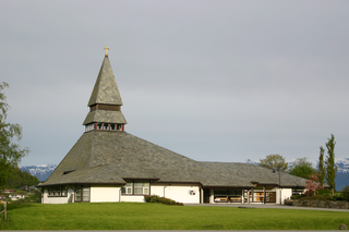
Vikøy Church is a parish church in Kvam municipality in Hordaland county, Norway. It is located in the village of Vikøy, a few kilometers south of the municipal centre of Norheimsund. The church is part of the Vikøy parish in the Hardanger og Voss deanery in the Diocese of Bjørgvin.


