
Mozambique, officially the Republic of Mozambique, is a country located in southeast Africa bordered by the Indian Ocean to the east, Tanzania to the north, Malawi and Zambia to the northwest, Zimbabwe to the west, and Eswatini and South Africa to the southwest. The sovereign state is separated from the Comoros, Mayotte and Madagascar by the Mozambique Channel to the east. The capital and largest city is Maputo.

Modes of transport in Mozambique include rail, road, water, and air. There are rail links serving principal cities and connecting the country with Malawi, Zimbabwe and South Africa. There are over 30,000 km of roads, but much of the network is unpaved.

Portuguese Mozambique or Portuguese East Africa were the common terms by which Mozambique was designated during the period in which it was a Portuguese colony. Portuguese Mozambique originally constituted a string of Portuguese possessions along the south-east African coast, and later became a unified colony, which now forms the Republic of Mozambique.

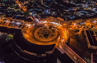
Maputo is the capital, and largest city of Mozambique. Located near the southern end of the country, it is within 120 kilometres of the borders with Eswatini and South Africa. The city has a population of 1,088,449 distributed over a land area of 347.69 km2 (134.24 sq mi). The Maputo metropolitan area includes the neighbouring city of Matola, and has a total population of 2,717,437. Maputo is a port city, with an economy centered on commerce. It is also noted for its vibrant cultural scene and distinctive, eclectic architecture. Maputo was formerly named Lourenço Marques until 1976.
Nampula is the capital city of Nampula Province in Northern Mozambique. With a population of 743,125, it is the third-largest city in Mozambique after Maputo and Matola. The city is located in the interior of Nampula Province, approximately 200 kilometers from the coast and is surrounded by plains and rocky outcrops. The city is a major regional centre for the entire Northern region of Mozambique, as well as parts of Central Mozambique and border areas of Malawi and Tanzania.

Nsanje is the main city in Nsanje District within the Southern Region of Malawi.
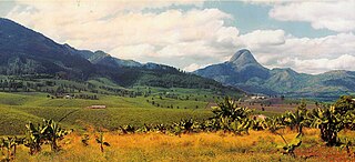
Gurúè is a town located in the northern part of Mozambique, near the center of the province of Zambezia. It serves as the principal town of Gurué District, and is Mozambique's largest tea estate. According to the 2007 census, the town had a population of 145,466, an increase from the 99,335 inhabitants counted in the 1997 census.

Nsanje is a district in the Southern Region of Malawi. The capital is Nsanje. The district covers an area of 1,942 square kilometres (750 sq mi) and has a population of 194,924.

The Port of Beira is a Mozambican port located in the city of Beira, capital of the Sofala Province. It is located in Sofala Bay, which forms a huge complex with the mouth of the Pungoe River, known as the Beira estuary, facing the Mozambique Channel. It is the second largest port in Mozambique, built to replace the port of Old Sofala in the 1890s.
Articles related to Mozambique include:
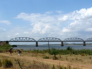
The Dona Ana Bridge spans the lower Zambezi River between the towns of Vila de Sena and Mutarara in Mozambique, effectively linking the two halves of the country. It was originally constructed as a railway bridge to link Malawi and the Moatize coal fields to the port of Beira.

Portos e Caminhos de Ferro de Moçambique is a state-owned company that oversees the railway system of Mozambique and its connected ports.
Railway stations in Mozambique include:

The history of rail transport in Mozambique began in the latter years of the nineteenth century.
Nyungwe is a Bantu language of Mozambique. It is used as a trade language throughout Tete Province. It belongs in the Southeastern Bantu branch, particularly in Guthrie zone N. It is closely related to Sena, Chewa, Nsenga and Tumbuka.

Nacala railway, also known as Northern Corridor railway and Nacala Corridor railway, is a railway line that operates in northern Mozambique on a 912 kilometres (567 mi) line that runs west from the port city of Nacala, crossing the central region of Malawi, connecting with the coal belt of Moatize, in northwest Mozambique. It is connected to the Dona Ana-Moatize railway branch and the Sena railway (Chipata-Lilongwe-Blantyre-Nhamayabue-Dondo). It also has a 262 kilometres (163 mi) branch line from Cuamba to Lichinga.
The Revolutionary Party of Mozambique was an armed rebel group in northern Mozambique during the Mozambican Civil War. Founded by Amos Sumane in 1974 or 1976, the PRM was strongly opposed to Mozambique's FRELIMO government and its communist ideology. The party waged a low-level insurgency in the provinces of Zambezia, Tete and Niassa from 1977. Sumane was captured in 1980 and executed by the Mozambican government in 1981. The PRM's leadership passed to Gimo Phiri under whom the party merged with another rebel group, RENAMO, in 1982.

Sena railway, also called Shire Highlands railway, Dondo-Malawi railway and North-South Malawi railway, is a railway that connects Dondo, Mozambique, to Chipata, in Zambia. It is c. 1000 km long, in a 1067 mm gauge.
Marka is a town located in Nsanje District in Malawi. It is the southernmost location in the country, serving as a border post for road and rail control between Malawi and Mozambique.
