The Guadiana River, or Odiana, is an international river defining a long stretch of the Portugal-Spain border, separating Extremadura and Andalucia (Spain) from Alentejo and Algarve (Portugal). The river's basin extends from the eastern portion of Extremadura to the southern provinces of the Algarve; the river and its tributaries flow from east to west, then south through Portugal to the border towns of Vila Real de Santo António (Portugal) and Ayamonte (Spain), where it flows into the Gulf of Cádiz. With a course that covers a distance of 829 kilometres (515 mi), it is the fourth-longest in the Iberian peninsula, and its hydrological basin extends over an area of approximately 68,000 square kilometres (26,000 sq mi).

Chaves is a city and a municipality in the north of Portugal. It is 10 km south of the Spanish border and 22 km south of Verín (Spain). The population in 2011 was 41,243, in an area of 591.23 km2. The municipality is the second most populous of the district of Vila Real. With origins in the Roman civitas Aquæ Flaviæ, Chaves has developed into a regional center. The urban area has 17,535 residents (2001).
Vila Velha is a coastal city in Espírito Santo, Brazil. It lies across from Vitória, the state capital. Its population was 396,323 (2005) and its area is 208.82 km².

Faro District is the southernmost district of Portugal, coincident with the Algarve. The administrative centre, or capital, is the city of Faro.

Vila Real de Santo António is a city, civil parish, and municipality in the Algarve, Portugal. The population in 2011 was 19,156, in an area of 61.25 km². It is one of the few municipalities in Portugal without territorial continuity: its territory comprises two parts, with the municipal seat located in the eastern part. Both the city and the municipality are the southeasternmost of Portugal. Vila Real de Santo António was founded after the 1755 Lisbon earthquake, and largely expanded in 1774 using the same architectural and construction techniques employed in the reconstruction of Lisbon after the disaster.

Ayamonte is a town and municipality located in the province of Huelva, (Spain) near the Guadiana River. According to the 2015 census, the city had a population of 20,357 inhabitants.

The Pombaline style was a Portuguese architectural style of the 18th century, named after Sebastião José de Carvalho e Melo, the first Marquês de Pombal, who was instrumental in reconstructing Lisbon after the earthquake of 1755. Pombal supervised the plans drawn up by the military engineers Manuel da Maia, Eugénio dos Santos and Elias Sebastian Pope. The new city was laid out on a grid plan with roads and pavements fixed at 40 ft wide (12 m). The previously standing royal palace was replaced with the Praça do Comércio which along with square Rossio defines the limits of the new city. Maia and Santos also outlined the form of the facades that were to line the streets, conceived on a hierarchical scheme whereby detail and size were delineated by the importance of the street. These were in a notably restrained neoclassical style partly the result of limited funds and the urgency of building but also thanks to the enlightenment concept of architectural rationality adhered to by Pombal. A standardized system of decoration was applied both inside and out with a distinctively reduced application of azulejo tiling.
Castro Marim and Vila Real de Santo António Marsh Natural Reserve is a natural reserve in Portugal.

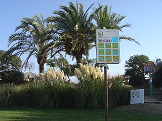
Vila Nova de Cacela, or simply Cacela, is a town and Civil parish in the municipality of Vila Real de Santo António, the southeasternmost of the Algarve, Portugal. The population in 2011 was 3,902, in an area of 46.03 km². Cacela is an exclave of the municipality of Vila Real de Santo António, one of only three in Portugal to have exclaves.

The Algarve Football Cup, previously known as Guadiana Trophy until 2013, is a pre-season friendly association football tournament played in Portugal.
The 2009 Guadiana Trophy competition has taken place between 16-18 July 2009 and featured Benfica, Olhanense, Athletic Bilbao and Anderlecht. Benfica won in the final against Olhanense.
The 2007 Guadiana Trophy competition took place between 3-5 August 2007 and featured Benfica, Sporting Clube de Portugal, and Real Betis. Benfica won in the final against rivals Sporting.

Vila Real is the capital and largest city of the Vila Real District, northern Portugal. The population in 2011 was 51,850, in an area of 378.80 square kilometres (146.26 sq mi).
The 2008 Guadiana Trophy competition took place between 25–27 July 2008 and featured Benfica, Sporting Clube de Portugal, and Blackburn Rovers. Sporting won in the final match against rivals Benfica.
The 2010 Guadiana Trophy was the 10th edition of the competition and took place between 30 July and 1 August 2010. It featured Benfica, Feyenoord, and Aston Villa.

The District of Porto, is located on the north-west coast of Portugal. The district capital is the city of Porto, the second largest city in the country. It is bordered by the Aveiro and Viseu districts to the south, Braga district to the north and Vila Real district to the east.
The 2007 Algarve Cup was the fourteenth edition of the Algarve Cup, an invitational women's football tournament held annually in Portugal. It took place between 7 and 12 March 2007 with the previous year's runners-up, the United States, winning the event for a record fifth time, breaking Norway's previous record of four championships, by defeating Denmark, 2-0, in the final game. Sweden ended up third defeating France, 3-1, in the bronze medal game.
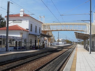
The Albufeira-Ferreiras Station is the railway station for the city of Albufeira, Algarve, in Portugal. Situated in the civil parish of Ferreiras, in the north of the municipality of Albufeira. The station opened on 1 July 1889.

Linha do Algarve is a railway line in the Algarve, which connects the stations of Lagos and Vila Real de Santo António.