
The Prince Charles Mountains are a major group of mountains in Mac. Robertson Land in Antarctica, including the Athos Range, the Porthos Range, and the Aramis Range. The highest peak is Mount Menzies. Other prominent peaks are Mount Izabelle and Mount Stinear. These mountains together with other scattered peaks form an arc about 260 miles long, extending from the vicinity of Mount Starlight in the north to Goodspeed Nunataks in the south.
Hemmen Ice Rise is an ice rise 11 miles (18 km) long and 2 to 4 kilometres wide, with an estimated area of 55 square kilometres (21 sq mi), located 17 kilometres (11 mi) off the northwest corner of Berkner Island in the Ronne Ice Shelf, Antarctica. The feature appears for the first time on a chart prepared at Ellsworth Station in 1957 by Captain Finn Ronne, U.S. Navy Reserve. The ice rise was subsequently noted in U.S. Earth Resources Technology Satellite imagery. It was named by the UK Antarctic Place-Names Committee for George E. Hemmen, Executive Secretary of the Scientific Committee on Antarctic Research in 1972; he served with the Falkland Islands Dependencies Survey as a meteorological observer at Admiralty Bay, 1952–53, and as Base Leader at Deception Island, 1953–54, and with the Royal Society Antarctic Expedition, 1956.
Høgfonna Mountain is a high, flat, snow-topped mountain with sheer rock sides, standing 3 miles (5 km) southeast of Hogskavlen Mountain in the Borg Massif, Queen Maud Land, Antarctica. It was mapped by Norwegian cartographers from surveys and air photos by the Norwegian–British–Swedish Antarctic Expedition (1949–1952), led by John Schjelderup Giæver, and named Høgfonna.

Isbrecht Glacier is a small glacier flowing south from Thurston Island in Antarctica between Cox Glacier and Hale Glacier. It was named by the Advisory Committee on Antarctic Names after JoAnn Isbrecht of the United States Geological Survey (USGS), Flagstaff, Arizona, a satellite image processing specialist who was part of the USGS team that compiled the 1:5,000,000-scale Advanced Very High Resolution Radiometer maps of Antarctica and the 1:250,000-scale Landsat image maps of the Siple Coast area in the 1990s.

Ising Glacier is a glacier flowing northwest between Isingen Mountain and Kvitkjolen Ridge in the Sverdrup Mountains of Queen Maud Land, Antarctica. It was photographed from the air by the Third German Antarctic Expedition (1938–39). It was mapped by Norwegian cartographers from surveys and air photos by the Norwegian–British–Swedish Antarctic Expedition (1949–1952), led by John Schjelderup Giæver, and from air photos by the Norwegian expedition (1958–59) and named Isingbreen.
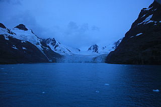
Risting Glacier is a glacier, 4.5 nautical miles long, lying north of Jenkins Glacier and flowing southeast into the head of Drygalski Fjord in the south part of South Georgia. Surveyed by the South Georgia Survey (SGS) under Duncan Carse in the period 1951-57, and named by the United Kingdom Antarctic Place-Names Committee (UK-APC) for Sigurd Risting (1870-1935), Norwegian whaling historian; secretary of Norsk Hvalfangerforening, 1918-35, and editor of Norsk Hvalfangst-Tidende, 1922-35. The German Antarctic Expedition under Wilhelm Filchner, 1911-12, named Drygalski Fjord and this glacier for Erich von Drygalski, leader of the German Antarctic Expedition, 1901-03, but the name for the glacier did not survive. A number of features in Antarctica, including Drygalski Glacier, are named for Drygalski.
Brautnuten Peak is a low peak 5 nautical miles (9 km) southeast of Snøkallen Hill, on the east side of Ahlmann Ridge in Queen Maud Land. It was mapped by Norwegian cartographers from surveys and air photos by the Norwegian–British–Swedish Antarctic Expedition (1949–52) and from air photos by the Norwegian expedition (1958–59) and named by the Norwegians.
The Nupshamrane Peaks are peaks just east of the Klumpane Peaks, on the west side of the Ahlmann Ridge in Queen Maud Land. Mapped by Norwegian cartographers from surveys and air photos by the Norwegian-British-Swedish Antarctic Expedition (NBSAE) (1949–52) and was named Nupshamrane.

Swift Glacier is a steep glacier about 2 nautical miles (3.7 km) long, close west of Jefford Point, James Ross Island. Named by United Kingdom Antarctic Place-Names Committee (UK-APC) following Falkland Islands Dependencies Survey (FIDS) surveys, 1958-61. The name is descriptive, this being one of the most active glaciers on the island.
Dugurdspiggen Peak is an isolated peak about 4 nautical miles north of the Borg Massif in Queen Maud Land. It was mapped by Norwegian cartographers from surveys and air photos by Norwegian–British–Swedish Antarctic Expedition (1949–52) and from air photos by the Norwegian expedition (1958–59) and named Dugurdspiggen.
Mount Moa is a mountain rising above 2,000 metres (6,600 ft) at the northern end of the Churchill Mountains in Antarctica. Located above Kiwi Pass and at the southern end of Kent Plateau, it was named after an extinct and flightless bird species in New Zealand, the moa. The naming is in association with the adjacent feature, Kiwi Pass, which was named after a familiar nickname for New Zealanders, the kiwi being also a species of flightless bird found only in New Zealand.
The Martin Nunataks are a pair of isolated nunataks situated along the northern margin of David Glacier, 9 nautical miles (17 km) southeast of Mount Wood, in Victoria Land, Antarctica. They were mapped by the United States Geological Survey (USGS) from surveys and U.S. Navy air photos, 1956–62, and were named by the Advisory Committee on Antarctic Names for Robert D. Martin, a USGS topographic engineer at McMurdo Station, 1961–62.
The Klumpane Peaks are a group of small rock peaks on the east side of the mouth of Strengen Valley, on the Ahlmann Ridge in Queen Maud Land, Antarctica. They were mapped by Norwegian cartographers from surveys and air photos by the Norwegian–British–Swedish Antarctic Expedition (1949–52) and named Klumpane.
Småtind Peak is a small peak close southeast of Fasettfjellet, near the east end of the Borg Massif in Queen Maud Land. It was mapped by Norwegian cartographers from surveys and air photos by the Norwegian-British-Swedish Antarctic Expedition (1949–52) and air photos by the Norwegian expedition of 1958–59 and named Småtind.
Terningskarvet Mountain is a large complex mountain just east of Mayr Ridge, forming the southeast portion of the Gjelsvik Mountains in Queen Maud Land. Mapped by Norwegian cartographers from surveys and air photos by Norwegian-British-Swedish Antarctic Expedition (NBSAE) (1949–52) and by Norwegian Antarctic Expedition (1958–59) and named Terningskarvet.
Tierney Peninsula is an ice-covered peninsula about 14 nautical miles (26 km) long, between Savage Glacier and Morgan Inlet in the east end of Thurston Island. The east extremity of the peninsula is Cape Annawan. These features were discovered on helicopter flights from the USS Burton Island and Glacier of the U.S. Navy Bellingshausen Sea Expedition in February 1960 and named by the Advisory Committee on Antarctic Names (US-ACAN). The peninsula was named for J.Q. Tierney, oceanographer aboard the Burton Island on this expedition. The cape was named for the ship Annawan of the United States Expedition of 1829-31, which with the Penguin sailed west from the South Shetland Islands in February 1830, holding a course between 62S and 58S and exploring as far as 103W, northward of this cape.
Vindegghallet Glacier is a glacier flowing west for 4 nautical miles (7 km) along the south side of Mount Flanuten in the Humboldt Mountains of Queen Maud Land. Discovered and photographed by the German Antarctic Expedition, 1938-39. Mapped by Norway from air photos and surveys by Norwegian Antarctic Expedition, 1956–60, and named Vindegghallet in association with nearby Vindegga Spur.
Vindegga Spur is a prominent ridge just south of Vindegghallet Glacier in the Humboldt Mountains of Queen Maud Land. Discovered and photographed by the German Antarctic Expedition, 1938-39. Mapped by Norway from air photos and surveys by Norwegian Antarctic Expedition, 1956–60, and named Vindegga.


