
Essex County Airport, informally known as Caldwell Airport, is a public use airport located in Fairfield Township, Essex County, New Jersey, two nautical miles (4 km) north of the central business district of Caldwell, a borough of northwestern Essex County in the U.S. state of New Jersey. It is owned by the Essex County Improvement Authority. This facility is included in the National Plan of Integrated Airport Systems for 2011–2015, which categorized it as a general aviation reliever airport.

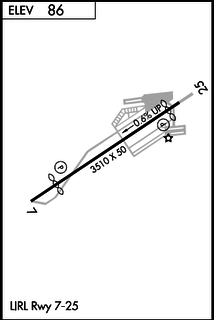
Lincoln Park Airport is a privately owned, public use airport located two nautical miles (4 km) north of the central business district of Lincoln Park, in Morris County, New Jersey, United States. It is included in the National Plan of Integrated Airport Systems for 2011–2015, which categorized it as a general aviation reliever airport.

North Palm Beach County Airport, also known as North County Airport, is an uncontrolled general aviation airport located 12 nautical miles (22 km) northwest of West Palm Beach off the Bee Line Highway in Palm Beach Gardens, Florida. The airport is owned by Palm Beach County and operated by the Palm Beach County Airports Department.
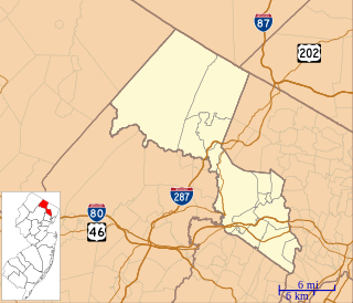
Central Jersey Regional Airport is a privately owned, public use airport in Somerset County, New Jersey, United States. The airport is one nautical mile (2 km) south of the central business district of Manville. It is located in Hillsborough Township and was formerly known as Kupper Airport. This facility is included in the National Plan of Integrated Airport Systems for 2011–2015, which categorized it as a general aviation reliever airport.

Jackson County Airport, also known as Reynolds Field, is a county-owned, public-use airport located two nautical miles (3.7 km) west of the central business district of Jackson, in Jackson County, Michigan, United States. It is a class D airport with operating control tower. It is included in the Federal Aviation Administration (FAA) National Plan of Integrated Airport Systems for 2017–2021, in which it is categorized as a regional general aviation facility.

Trenton–Robbinsville Airport is a privately owned, public use airport located one nautical mile (2 km) east of the central business district of Robbinsville, in Mercer County, New Jersey, United States. It is included in the National Plan of Integrated Airport Systems for 2011–2015, which categorized it as a general aviation reliever airport.

W. K. Kellogg Airport is a city-owned, public-use, joint civil-military airport located three nautical miles (6 km) west of the central business district of Battle Creek, a city in Calhoun County, Michigan, United States. The airport is accessible by road from Helmer Road, and is located near I-94. It is included in the Federal Aviation Administration (FAA) National Plan of Integrated Airport Systems for 2017–2021, in which it is categorized as a regional general aviation facility. It is also known as W. K. Kellogg Regional Airport.
Greenwood Lake Airport is a public use airport located one nautical mile (2 km) east of the central business district of West Milford, in Passaic County, New Jersey, United States. The airport is owned by New Jersey Department of Transportation. It is included in the National Plan of Integrated Airport Systems for 2011–2015, which categorized it as a general aviation facility.

Aeroflex–Andover Airport is a public-use airport located two nautical miles (3.704 km) north of Andover within Kittatinny Valley State Park in Sussex County, New Jersey, United States. The airport is publicly owned by the New Jersey Forest Fire Service and used as a base for aerial wildfire suppression.

Camden County Airport is a privately owned, public use airport in Camden County, New Jersey, United States. It is located one nautical mile (2 km) southwest of the central business district of Berlin, New Jersey. The airport was established in March 1929.
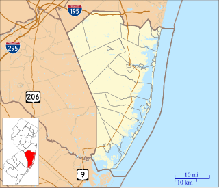
Lakewood Airport is a public use airport located three nautical miles (6 km) southeast of the central business district of Lakewood, in Ocean County, New Jersey, United States. The airport is owned by Lakewood Township. It is included in the National Plan of Integrated Airport Systems for 2011–2015, which categorized it as a general aviation facility.

Cross Keys Airport is a privately owned, public use airport located one nautical mile (2 km) south of the Cross Keys area of Monroe Township in Gloucester County, New Jersey, United States. A skydiving operation is based at the airport.

Robert J. Miller Air Park, also known as the Ocean County Airport, is a county-owned public-use airport in Ocean County, New Jersey, United States. It is located five nautical miles southwest of the central business district of Toms River, New Jersey. Opened in 1968 as the Ocean County Air-Park, the airport is named after Ocean County Freeholder Robert J. Miller who worked to expand the airport while in office. Miller died in 1969 in an accident that occurred at the airport; it was subsequently named after him in 1970.

Marianna Municipal Airport is five miles northeast of Marianna, in Jackson County, Florida. The FAA's National Plan of Integrated Airport Systems for 2009–2013 categorized it as a general aviation airport. It was formerly Graham Air Base.
Saratoga County Airport is a county-owned, public-use airport located three nautical miles (6 km) southwest of the central business district of Saratoga Springs, a city in Saratoga County, New York, United States. It is included in the National Plan of Integrated Airport Systems for 2011–2015, which categorized it as a general aviation facility.
Bucks Airport is a privately owned, public-use airport located three nautical miles northeast of the central business district of Bridgeton, a city in Cumberland County, New Jersey, United States.
Kroelinger Airport is a privately owned, public-use airport in Cumberland County, New Jersey, United States. It is located three nautical miles north of the central business district of Vineland.
Miami Homestead General Aviation Airport is a county-owned public-use airport in unincorporated Miami-Dade County, Florida, United States, located four nautical miles (7 km) northwest of the central business district of Homestead.
New Castle Municipal Airport is a small municipal airport located in Union Township, Lawrence County, Pennsylvania serving Lawrence County, Pennsylvania, part of the Pittsburgh metropolitan area. Union Township is an outskirt of New Castle, Pennsylvania hence the name. The airport is located four nautical miles northwest of the central business district of New Castle. The airport is a public-owned airport and is controlled by the Lawrence County Airport Authority.

Cattaraugus County-Olean Airport is a city-owned, public-use airport located 10 nautical miles north of the central business district of Olean, a city in Cattaraugus County, New York, United States. It is included in the National Plan of Integrated Airport Systems for 2011–2015, which categorized it as a general aviation facility.


