The Mid-Atlantic Ridge is a mid-ocean ridge located along the floor of the Atlantic Ocean, and part of the longest mountain range in the world. In the North Atlantic, the ridge separates the North American from the Eurasian plate and the African plate, north and south of the Azores triple junction. In the South Atlantic, it separates the African and South American plates. The ridge extends from a junction with the Gakkel Ridge northeast of Greenland southward to the Bouvet triple junction in the South Atlantic. Although the Mid-Atlantic Ridge is mostly an underwater feature, portions of it have enough elevation to extend above sea level, for example in Iceland. The ridge has an average spreading rate of about 2.5 centimetres (1 in) per year.

Sticklepath is a village and civil parish on Dartmoor, in the county of Devon, England. It gives its name to one of the most important geological faults in south-west England, thought to have originated during the Tertiary period and known variously as the Sticklepath fault, Sticklepath fault zone, Lustleigh-Sticklepath fault or Sticklepath-Lustleigh fault.
The Possession Islands are a group of small islands and rocks extending over an area of about 7 nautical miles, lying in the western part of the Ross Sea, lying 5 nautical miles south-east of Cape McCormick, in Victoria Land, Antarctica. The Possession Islands were named by Captain James Clark Ross, Royal Navy, in commemoration of the planting of the British flag here on January 12, 1841.
Alexander Pavlovich Vinogradov was a Soviet geochemist, academician (1953), and Hero of Socialist Labour.

Cape Hooker is the south-eastern point of Low Island, in the South Shetland Islands of Antarctica. The feature was roughly charted by nineteenth century sealers; it was further charted by Commander Henry Foster in 1829 but shown as the north-eastern point of the island. Following air photography by the Falkland Islands and Dependencies Aerial Survey Expedition in 1956, the charted shape of the island was drastically altered and the name Cape Hooker was applied to its south-eastern point as originally described.

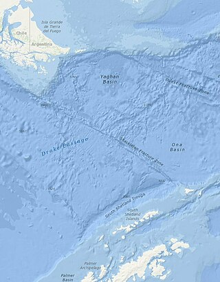
The Shackleton Fracture Zone (SFZ) is an undersea fracture zone, mid-oceanic ridge and fault located in the Drake Passage, at the separation between the Scotia plate from the Antarctic plate. It extends between 59° and 60°40' south latitude and between 56°30' and 61° west longitude and runs in a northwest to southeast direction from the South American continental shelf to the South Shetland Islands. Chile claims the area as part of its Outer Continental Shelf boundary.
Aspland Island is a small island 7.4 km (4 nmi) west of Gibbs Island in the South Shetland Islands of Antarctica. The name dates back to at least 1821.

Telefon Bay is a small bay on the north-west coast of Port Foster, Deception Island, in the South Shetland Islands of Antarctica. It is surmounted by Telefon Ridge. The name appears on the chart of the French Antarctic Expedition under Charcot, 1908–10.
The Mulock Glacier is a large, heavily crevassed glacier which flows into the Ross Ice Shelf 40 kilometers south of the Skelton Glacier in the Ross Dependency, Antarctica.
The Antipodes fracture zone is an undersea fracture zone named in association with Antipodes Island. The name was proposed by Dr. Steven C. Cande of the Scripps Institution of Oceanography, and approved by the Advisory Committee on Undersea Features in September 1997.
Kosminskaya Fracture Zone is an undersea fracture zone named for Professor Irina Kosminskaya, a Russian scientist specializing in Marine Geophysics and Seismology. The name was proposed by Dr. Galina Agapova of the Geological Institute of the Russian Academy of Sciences, and was approved by the Advisory Committee on Undersea Features in September 1997.

Pottinger Point is a low-lying, ice-free promontory 4 km (2.5 mi) east of Round Point, about 500 m long, on the north coast of King George Island in the South Shetland Islands of Antarctica. It was named by the United Kingdom Antarctic Place-Names Committee (UK-APC) in 1960 for Captain Pottinger, Master of the Tartar from London, who visited the South Shetland Islands in 1821–22.

Mount Faraway is a prominent, snow-covered mountain, 1,175 metres (3,850 ft) high, marking the southern extremity of the Theron Mountains of Antarctica. It was discovered by the Commonwealth Trans-Antarctic Expedition in 1956, and so named because during days of sledging toward this mountain they never seemed to be any nearer to it.

The Pearl Rocks are a group of rocks covering an area 6 km (3.7 mi) by 4 km (2.5 mi) close to the west coast of Tower Island in the Palmer Archipelago of Antarctica. The name was given by Falkland Islands and Dependencies Aerial Survey Expedition (FIDASE) (1955–57) and is descriptive of the numerous snow-covered rocks in the group.
Goldsmith Glacier is a glacier flowing west-northwest through the Theron Mountains of Antarctica, 6 nautical miles (11 km) south of Tailend Nunatak. It was first mapped in 1956–57 by the Commonwealth Trans-Antarctic Expedition (CTAE) and named for Rainer Goldsmith, medical officer with the advance party of the CTAE in 1955–56.
Miethe Glacier is a glacier 3 nautical miles (6 km) long, flowing northwest into Gerlache Strait to the south of Mount Banck, on the west coast of Graham Land, Antarctica. The glacier appears on an Argentine government chart of 1952. It was named by the UK Antarctic Place-Names Committee in 1960 for Adolf Miethe, a German chemist who introduced the first panchromatic emulsion for photographic plates in 1903.

Lucchitta Glacier is a glacier about 20 nautical miles (37 km) long flowing south from the Hudson Mountains of Antarctica into Pine Island Bay. It was named by the Advisory Committee on Antarctic Names after geologist Baerbel K. Lucchitta of the United States Geological Survey, Flagstaff, Arizona, a specialist in the use of satellite imagery for geological and glaciological studies from the early 1980s to the early 2000s (decade), and one of the pioneers in the use of imagery for glacier velocity measurements in Antarctica.
The Hero Fracture Zone is an undersea fracture zone in the Antarctic. Its name was approved by the Advisory Committee on Undersea Features in June 1987.

Lada Terra, named for a Slavic goddess of Love, is a major landmass near the south pole of Venus which is centered at 60°S and 20°E and has a diameter of 8,615 kilometres (5,353 mi). It is defined by the International Astronomical Union as one of the three "major landmasses," or terrae, of Venus. The term "landmass" is not analogous to the landmass on Earth, as there are no apparent oceans on Venus. The term here applies to a substantial portion of land that lies above the average planetary radius, and corresponds to highlands.
Vinogradov is a Russian surname.


