Related Research Articles

Matthew Paris, also known as Matthew of Paris, was an English Benedictine monk, chronicler, artist in illuminated manuscripts and cartographer, based at St Albans Abbey in Hertfordshire. He wrote a number of works, mostly historical, which he scribed and illuminated himself, typically in drawings partly coloured with watercolour washes, sometimes called "tinted drawings". Some were written in Latin, some in Anglo-Norman or French verse.
A mappa mundi is any medieval European map of the world. Such maps range in size and complexity from simple schematic maps 25 millimetres or less across to elaborate wall maps, the largest of which to survive to modern times, the Ebstorf map, was around 3.5 m in diameter. The term derives from the Medieval Latin words mappa and mundus (world).
"The Rhyming Poem", also written as "The Riming Poem", is a poem of 87 lines found in the Exeter Book, a tenth-century collection of Old English poetry. It is remarkable for being no later than the 10th century, in Old English, and written in rhyming couplets. Rhyme is otherwise virtually unknown among Anglo-Saxon literature, which used alliterative verse instead.
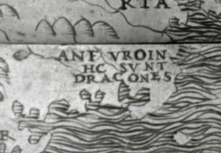
"Here be dragons" means dangerous or unexplored territories, in imitation of a medieval practice of putting illustrations of dragons, sea monsters and other mythological creatures on uncharted areas of maps where potential dangers were thought to exist.
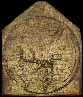
The Hereford Mappa Mundi is a medieval map of the known world, of a form deriving from the T and O pattern, dating from c. 1300. It is displayed at Hereford Cathedral in Hereford, England. It is the largest medieval map still known to exist. A larger mappa mundi, the Ebstorf map, was destroyed by Allied bombing in 1943, though photographs of it survive.
The earliest known world maps date to classical antiquity, the oldest examples of the 6th to 5th centuries BCE still based on the flat Earth paradigm. World maps assuming a spherical Earth first appear in the Hellenistic period. The developments of Greek geography during this time, notably by Eratosthenes and Posidonius culminated in the Roman era, with Ptolemy's world map, which would remain authoritative throughout the Middle Ages.

The Utrecht Psalter is a ninth-century illuminated psalter which is a key masterpiece of Carolingian art; it is probably the most valuable manuscript in the Netherlands. It is famous for its 166 lively pen illustrations, with one accompanying each psalm and the other texts in the manuscript. The precise purpose of these illustrations, and the extent of their dependence on earlier models, have been matters of art-historical controversy. The psalter spent the period between about 1000 to 1640 in England, where it had a profound influence on Anglo-Saxon art, giving rise to what is known as the "Utrecht style". It was copied at least three times in the Middle Ages. A complete facsimile edition of the psalter was made in 1875, and another in 1984 (Graz).

The Parker Library is the rare books and manuscripts library of Corpus Christi College, Cambridge. It is known throughout the world due to its invaluable collection of over 600 manuscripts, particularly medieval texts, the majority of which were bequeathed to the College by Archbishop of Canterbury Matthew Parker, a former Master of Corpus Christi College.

The British Library is the national library of the United Kingdom and is one of the largest libraries in the world. It is estimated to contain between 170 and 200

Hemming's Cartulary is a manuscript cartulary, or collection of charters and other land records, collected by a monk named Hemming around the time of the Norman Conquest of England. The manuscript comprises two separate cartularies that were made at different times and later bound together; it is in the British Library as MS Cotton Tiberius A xiii. The first was composed at the end of the 10th or beginning of the 11th century. The second section was compiled by Hemming and was written around the end of the 11th or the beginning of the 12th century. The first section, traditionally titled the Liber Wigorniensis, is a collection of Anglo-Saxon charters and other land records, most of which are organized geographically. The second section, Hemming's Cartulary proper, combines charters and other land records with a narrative of deprivation of property owned by the church of Worcester.

Pietro Vesconte was a Genoese cartographer and geographer. A pioneer of the field of the portolan chart, he influenced Italian and Catalan mapmaking throughout the fourteenth and fifteenth centuries. He appears to have been the first professional mapmaker to sign and date his works regularly.

The Psalter World Map is the name historiography gave to a medieval world map that was found in a psalter. This mappa mundi is now conserved at the British Library in London.
Anglo-Saxon riddles are a significant genre of Anglo-Saxon literature. The riddle was a major, prestigious literary form in early medieval England, and riddles were written both in Latin and Old English verse. The pre-eminent composer of Latin riddles in early medieval England was Aldhelm, while the Old English verse riddles found in the tenth-century Exeter Book include some of the most famous Old English poems.
On the Resting-Places of the Saints is a heading given to two early medieval pieces of writing, also known as Þá hálgan and the Secgan, which exist in various manuscript forms in both Old English and Latin, the earliest surviving manuscripts of which date to the mid-11th century. Secgan is so named from its Old English incipit, Secgan be þam Godes sanctum þe on Engla lande aerost reston "Tale of God's saints who first rested in England"), and is a list of fifty places which had shrines and remains of Anglo-Saxon saints. Þá hálgan is a version of the so-called Kentish Royal Legend is a heading which appears to be for both texts, as the Kentish legend, which comes first, is actually an account of how various members of the royal family of Kent, descendants of Aethelbert of Kent, founded monasteries and came to be regarded as saints. As such it is closer to other hagiographical texts than to the list of burial sites that follows it. The texts describe people living from the 7th to 10th centuries, and they exist in both Old English and Latin versions, but both have their earliest known manuscripts dating from the 11th century.
Kevin Kiernan is an American scholar of Anglo-Saxon literature. Kiernan is the editor of the Electronic Beowulf and an acknowledged expert on the Beowulf manuscript. Kiernan is the T. Marshall Hahn Sr. Professor of Arts and Sciences Emeritus at the University of Kentucky. He was inducted into the University of Kentucky College of Arts and Sciences Hall of Fame in 2015.

The Tiberius Psalter is one of at least four surviving Gallican psalters produced at New Minster, Winchester in the years around the Norman conquest of England. The manuscript can now be seen fully online at the British Library website.

Fragmentology is the study of surviving fragments of manuscripts. A manuscript fragment may consist of whole or partial leaves, typically made of parchment, conjugate pairs or sometimes gatherings of a parchment book or codex, or parts of single-leaf documents such as notarial acts. They are commonly found in book bindings, especially printed books from the 15th to the 17th centuries, used in a variety of ways such as wrappers or covers for the book, as endpapers, or cut into pieces and used to reinforce the binding. In other non-Western manuscript cultures, fragments of paper manuscripts and other materials, takes place beside parchment, including board covers that many times reused written paper.

John Shirley was an author, translator, and scribe. As a scribe of later Middle English literature, he is particularly known for works by John Lydgate and Geoffrey Chaucer.
Stephen Murray, Professor Emeritus of the Department of Art History and Archaeology at Columbia University, is an architectural historian, specialising in Romanesque and Gothic architecture. Before his retirement, Murray held the Lisa and Bernard Selz chair in Medieval Art History at Columbia University. He has written several important monographs on French Gothic cathedrals, including Troyes, Beauvais, and Amiens. His work combines analysis of architectural details with discussion of medieval writing about cathedrals. He is considered a pioneer in the development of digital media and visual arts resources for educational use.
References
- ↑ Bradshaw, Shannon; Foys, Martin (2012). "Developing Digital Mappaemundi: An Agile Mode for Annotating Medieval Maps". Digital Medievalist. 7. doi: 10.16995/dm.38 .
- ↑ Porter, Dorothy; Bradshaw, Shannon; Foys, Martin Kennedy (2016-02-10). "The DM Environment: From Annotation to Dissemination".
{{cite journal}}: Cite journal requires|journal=(help) - ↑ Crossley, Cat (2018-07-29). "The Virtual Mappa Project and DM: Online Editions of Medieval Maps and More".
- ↑ Woodward, David. “Medieval Mappaemundi,” in The History of Cartography, Vol. 1: Cartography in Prehistoric, Ancient, and Medieval Europe and the Mediterranean, edited by J. B. Harley and David Woodward (University of Chicago Press, 1987), 292.
- ↑ Vaughn, Katie (2017-04-10). "Digitizing the middle ages".
- ↑ Wisconsin Public Television (2018-05-16). "The Digital Mappa Project".
- ↑ Medievalist.net (2018-04-16). "Digital Mappa 1.0 now online – new digital resource for medievalists".
- ↑ Progressive Geographies (2018-08-02). "The Virtual Mappa Project and Digital Mappa – Online editions of Medieval Maps from the British Library and elsewhere".