Visscher panorama

Last updated

The Visscher panorama is an engraving by Claes Visscher (1586-1652) depicting a panorama of London. It shows an imagined view of London in around 1600. The engraving was first published in Amsterdam in 1616, with the title "Londinum Florentissima Britanniae Urbs Toto Orbe Celeberrimum Emporiumque".

Overview

The engraving comprises four separate plates creating a continuous panorama over 2 metres (6.6 ft) long. It provides one of the best views of London before the Great Fire in 1666. From a viewpoint on the south bank of the River Thames, it shows (from west to east, left to right) mansions on the north bank of the river: Whitehall Palace, York House, Durham House, old Somerset House, Burley House, Arundel House and Essex House, then Old St Paul's Cathedral without the spire which was lost after it was struck by lightning in 1561, the low-rise medieval City of London dominated by the spires and steeples of its churches, Old London Bridge covered by shops and houses, and the Tower of London and St Katharine Docks, with distant views of Harrow on the Hill, windmills at Hampstead, and the spires of Hackney and Stepney. Prominent buildings depicted on the south bank are three theatres, The Swan, The Globe and the Beargarden, and the churches of St Mary Overie (rebuilt after a fire in 1212, later to become Southwark Cathedral), and St Olave's. There are many ships in the river. In the sky above the city, to the right of St Paul's, are angels holding a banderole with the title "London", to either side appear angels bearing trumpets decorated with the royal coat of arms and the arms of the City of London and then in the upper corners cartouches framed with cherubs.

London panorama, 1616b.jpg
A panorama of London by Claes Visscher, 1616. Old St Paul's Cathedral had lost its spire by this time. The two theatres in the foreground on the Southwark side of the River Thames are The Bear Garden and The Globe. The large church in the foreground is St Mary Overie, now Southwark Cathedral.

Visscher probably never visited London. There are various theories as to how the image was compiled. One is that he worked from a combination of maps and map-views with a various dates, so the engraving uses a variety of viewpoints. As a result, it contains some inaccuracies: in particular, Visscher shows the Globe Theatre as octagonal, whereas archaeological evidence shows it was 20-sided, and the river is straightened to simplify the view. The engraving may be based on John Norden's Civitas Londini from around 1600, printed around 1615, the only complete surviving copy of which is in the Gardie Collection at the Royal Library in Stockholm, now held by the Nationalmuseum. Another is that he himself had no part in composing the view, and instead worked from sketches that were compiled several years before they passed into his hands. One possibility is that they were the work of his publisher, Jodocus Hondius, who spent several years in London. It's equally possible that they were the work of Hondius's brother-in-law, Pieter van den Keere, who also lived and worked in London, and who in the same year (1616) produced a panorama of Istanbul (then known as Constantinople) in precisely the same style - that is to say, under a heavy headline, and accompanied by tracts of Latin text arranged in 16 columns. Moreover there further is evidence, in the engraving styles, to suggest that Visscher and Van den Keere collaborated, since the same hand is, in places, at work in both the London and Istanbul panoramas.

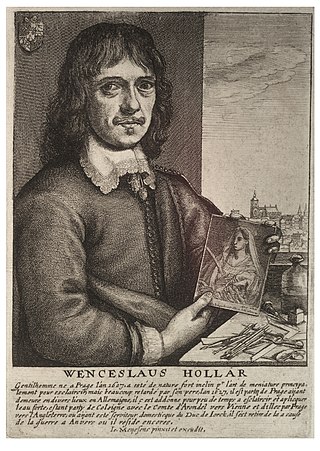
A similar engraving of London by Wenceslas Hollar in 1647 depicts a similar view, on six plates, Long View of London from Bankside , based on drawings done by Hollar in London in the early 1640s, from the tower of St Mary Overie. Hollar's panorama has a single viewpoint, and shows the River Thames curving sinuously from left to right past the viewpoint.

The Royal Great Seal used from 1663 to 1672 shows Charles II on horseback, with a panorama of London behind, based on Visscher's print.

In 2014 Zimbabwe-born artist Robin Reynolds set out to redraw the Visscher panorama, arranging modern London on the quirky Visscher landscape. The work was displayed at the Guildhall Art Gallery as part of the City of London's Shakespeare400 and Great Fire anniversary celebrations.

Related Research Articles

<span class="mw-page-title-main">Southwark</span> District of Central London, England

Southwark is a district of Central London situated on the south bank of the River Thames, forming the north-western part of the wider modern London Borough of Southwark. The district, which is the oldest part of South London, developed due to its position at the southern end of the early versions of London Bridge, for centuries the only dry crossing on the river. Around 43 AD, engineers of the Roman Empire found the geographic features of the south bank suitable for the placement and construction of the first bridge.

<span class="mw-page-title-main">Jan Janssonius</span> Dutch cartographer and publisher

Johannes Janssonius was a Dutch cartographer and publisher who lived and worked in Amsterdam in the 17th century.

<span class="mw-page-title-main">Bankside</span> Human settlement in England

Bankside is an area of London, England, within the London Borough of Southwark. Bankside is located on the southern bank of the River Thames, 1.5 miles (2.4 km) east of Charing Cross, running from a little west of Blackfriars Bridge to just a short distance before London Bridge at St Mary Overie Dock. It is part of a business improvement district known as 'Better Bankside'.

<span class="mw-page-title-main">Jodocus Hondius</span> Flemish and Dutch engraver and cartographer (1563–1612)

Jodocus Hondius was a Flemish and Dutch engraver and cartographer. He is sometimes called Jodocus Hondius the Elder to distinguish him from his son Jodocus Hondius II. Hondius is best known for his early maps of the New World and Europe, for re-establishing the reputation of the work of Gerard Mercator, and for his portraits of Francis Drake. He inherited and republished the plates of Mercator, thus reviving his legacy, also making sure to include independent revisions to his work. One of the notable figures in the Golden Age of Dutch cartography, he helped establish Amsterdam as the center of cartography in Europe in the 17th century.

<span class="mw-page-title-main">Wenceslaus Hollar</span> Bohemian graphic artist (1607–1677)

Wenceslaus Hollar was a prolific and accomplished Bohemian graphic artist of the 17th century, who spent much of his life in England. He is known to German speakers as Wenzel Hollar; and to Czech speakers as Václav Hollar. He is particularly noted for his engravings and etchings. He was born in Prague, died in London, and was buried at St Margaret's Church, Westminster.

<span class="mw-page-title-main">Shakespeare's funerary monument</span> Monument in Stratford-upon-Avon

The Shakespeare funerary monument is a memorial to William Shakespeare located inside Holy Trinity Church at Stratford-upon-Avon in Warwickshire, the church in which Shakespeare was baptised and where he was buried in the chancel two days after his death.

<span class="mw-page-title-main">Leo Belgicus</span> Cartographic design symbolising the Netherlands

The Leo Belgicus was used in both heraldry and map design to symbolize the former Low Countries with the shape of a lion.

<span class="mw-page-title-main">Arundel House</span> Demolished mansion in City of Westminster, London

Events from the year 1677 in art.

The city of London has long been a subject for panoramas by artists, mapmakers, and topographers. Many of their works have this as their title.

<span class="mw-page-title-main">Claes Jansz. Visscher</span> Dutch mapmaker

Claes Janszoon Visscher was a Dutch Golden Age draughtsman, engraver, mapmaker, and publisher. He was the founder of the successful Visscher family mapmaking business. The firm that he established in Amsterdam would be passed down his generations until it was sold to Peter Schenk.

<span class="mw-page-title-main">George Cooke (engraver)</span>

George Cooke, was an English line engraver.

<span class="mw-page-title-main">Pieter van den Keere</span> Flemish engraver, publisher, and globe maker

Pieter van den Keere was a Flemish engraver, publisher and globe maker who worked for the most part of his career in England and the Dutch Republic.

The Rhinebeck panorama is panoramic view of London dated to 1806–7. The work was found in Rhinebeck, New York in 1941, in the attic of a house, being used to line a barrel of pistols. It was acquired by the Museum of London in 1998.

<span class="mw-page-title-main">Abraham Goos</span>

Abraham Goos was a Dutch cartographer, publisher, and engraver. He made globes, maps of North America, a comprehensive map of European coastlines, and the first printed Hebrew language map of The Holy Land.

Long View of London from Bankside is a panoramic etching made by Wenceslas Hollar in Antwerp in 1647. It depicts a panorama of London, based on drawings done while Hollar was in London in the early 1640s. Unlike earlier panoramas of London, Hollar's panorama takes a single viewpoint, the tower of St Saviour in Southwark, from where he made the drawings. It shows the River Thames curving sinuously from left to right past the viewpoint.

The Grand Panorama of London from the Thames is an 1844 wood engraving depicting the north bank of the Thames river in London running from Western Stone Wharf by the unfinished Houses of Parliament to the Belfast, Cork, Leith and Glasgow Steam Wharf, just east of St Katharine Docks; a distance of approximately ten miles. An illustration, based on the engraving, was published as four separate supplements to the Pictorial Times and when joined were approximately 12 feet in length.

<span class="mw-page-title-main">Copperplate map of London</span> Map of the City of London created in 1550s

The "Copperplate" map of London is an early large-scale printed map of the City of London and its immediate environs, surveyed between 1553 and 1559, which survives only in part. It is the earliest true map of London. The original map was probably designed for hanging on a wall, and is believed to have measured approximately 3 feet 8 inches (112 cm) high by 7 feet 5 inches (226 cm) wide. No copies of the printed map itself are known to have survived; but between 1962 and 1997 three of the original engraved copper printing-plates – from a probable total of 15 – were identified. Although only a fragmentary portion of the map is known, the three plates cover the greater part of the built-up heart of the City of London.

<span class="mw-page-title-main">Statue of Robert Clayton</span> Sculpture by Grinling Gibbons

The statue of Robert Clayton stands at the entrance to the North Wing of St Thomas' Hospital, Lambeth, London. The sculptor was Grinling Gibbons, and the statue was executed around 1700–1714. Sir Robert was a banker, politician and Lord Mayor of London. As President of St Thomas', he was responsible for the complete rebuilding of the hospital, and associated church in the late 17th century. The statue was designated a Grade I listed structure in 1979.

Colette van den Keere (1568–1629) was a Dutch engraver who was the sister of engraver Pieter van den Keere. She married his master, the cartographer Jodocus Hondius in 1587 and she ran the family business for several years. She is credited with engraving a posthumous portrait of her husband.

References